 Old Cumbria Gazetteer
 |
 |
|
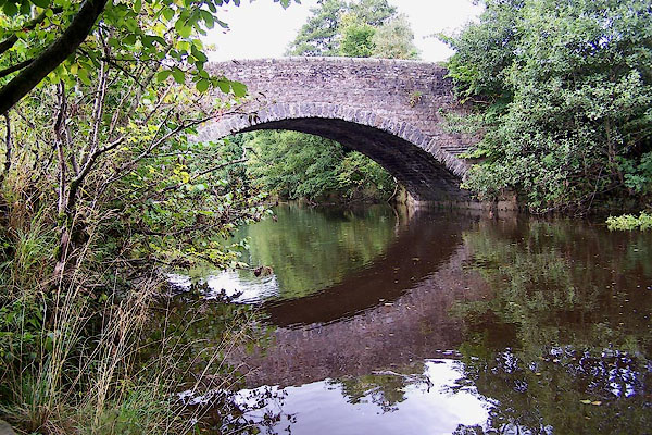
| Barth Bridge, Dent | ||
| Barth Bridge | ||
| site name:- | Dee, River | |
| civil parish:- | Dent (formerly Yorkshire) | |
| county:- | Cumbria | |
| locality type:- | bridge | |
| coordinates:- | SD69478790 | |
| 1Km square:- | SD6987 | |
| 10Km square:- | SD68 | |
|
|
||
 BJW12.jpg (taken 23.9.2005) 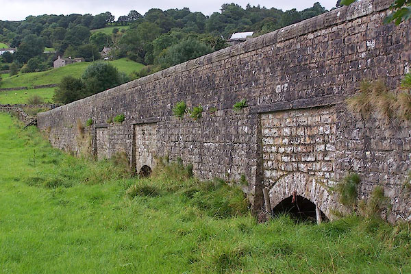 BJW13.jpg (taken 23.9.2005) |
||
|
|
||
| evidence:- | old map:- OS County Series (Yrk 64 9) placename:- Barth Bridge |
|
| source data:- | Maps, County Series maps of Great Britain, scales 6 and 25
inches to 1 mile, published by the Ordnance Survey, Southampton,
Hampshire, from about 1863 to 1948. |
|
|
|
||
| evidence:- | database:- Listed Buildings 2010 placename:- Barth Bridge |
|
| source data:- | courtesy of English Heritage "BARTH BRIDGE / / BARTH LANE / DENT / SOUTH LAKELAND / CUMBRIA / II / 484234 / SD6947887913" |
|
| source data:- | courtesy of English Heritage "Public road bridge over River Dee, with attached causeway crossing meadow to south. Late C18. Coursed sandstone rubble. The bridge has a single segmental arch with rubble voussoirs, a squinch at the north-west corner and slightly humped parapets with chiselled rounded coping. The parapets continue to the south along a straight causeway which has a series of low segmental-arched flood sluices in rectangular panels." |
|
|
|
||
 Lakes Guides menu.