 Old Cumbria Gazetteer
 |
 |
|
| Bewley, Bolton | ||
| Bewley | ||
| civil parish:- | Bolton (formerly Westmorland) | |
| county:- | Cumbria | |
| locality type:- | locality | |
| coordinates:- | NY64822132 (etc) | |
| 1Km square:- | NY6421 | |
| 10Km square:- | NY62 | |
|
|
||
| evidence:- | old map:- Speed 1611 (Cum/EW) placename:- Buley |
|
| source data:- | Map, hand coloured engraving, Kingdome of Great Britaine and
Ireland, scale about 36 miles to 1 inch, by John Speed, about
1610-11, published by Thomas Bassett, Fleet Street and Richard
Chiswell, St Paul's Churchyard, London, 1676?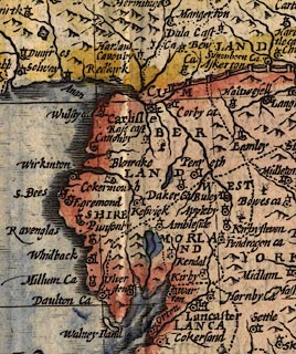 click to enlarge click to enlargeSPD6Cm.jpg "Buley" dot, circle, and tower item:- private collection : 85 Image © see bottom of page |
|
|
|
||
| evidence:- | old map:- Sanson 1679 placename:- Buley |
|
| source data:- | Map, hand coloured engraving, Ancien Royaume de Northumberland
aujourdhuy Provinces de Nort, ie the Ancient Kingdom of
Northumberland or the Northern Provinces, scale about 9.5 miles
to 1 inch, by Nicholas Sanson, Paris, France, 1679. click to enlarge click to enlargeSAN2Cm.jpg "Buley" circle, building and tower, flag; town? item:- Dove Cottage : 2007.38.15 Image © see bottom of page |
|
|
|
||
 Lakes Guides menu.