 Old Cumbria Gazetteer
 |
 |
|
| Duddon Viaduct, Broughton West | ||
| Duddon Viaduct | ||
| site name:- | Whitehaven and Furness Junction Railway | |
| site name:- | Duddon, River | |
| civil parish:- | Broughton West (formerly Lancashire) | |
| county:- | Cumbria | |
| locality type:- | railway viaduct | |
| locality type:- | viaduct | |
| coordinates:- | SD200856 | |
| coordinates:- | SD204856 | |
| 1Km square:- | SD2085 | |
| 10Km square:- | SD28 | |
|
|
||
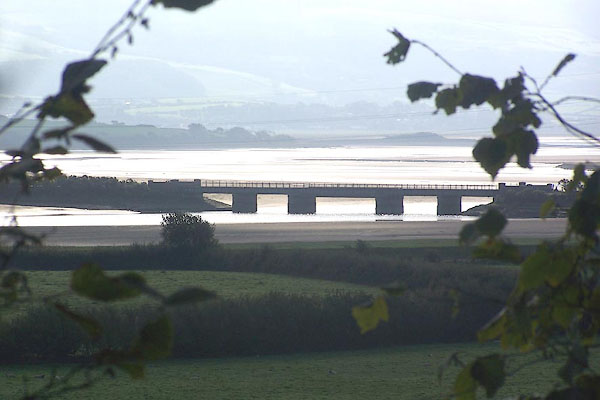 BMS50.jpg (taken 30.9.2006) 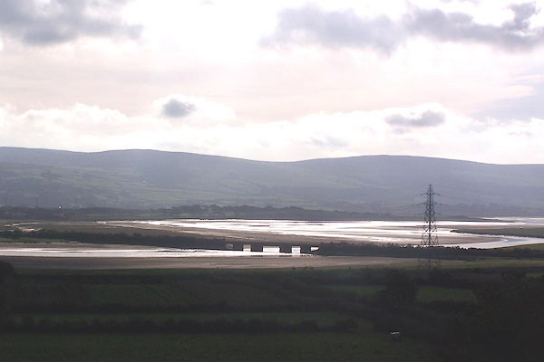 BMS51.jpg (taken 30.9.2006) |
||
|
|
||
| evidence:- | old map:- OS County Series (Lan 10 3) |
|
| source data:- | Maps, County Series maps of Great Britain, scales 6 and 25
inches to 1 mile, published by the Ordnance Survey, Southampton,
Hampshire, from about 1863 to 1948. OS County Series (Lan 10 4) 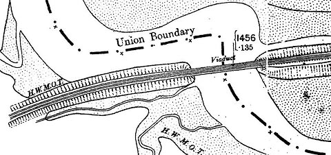 click to enlarge click to enlargeCSRY0115.jpg "Viaduct" from near High Shaw to Foxfield Point |
|
|
|
||
| evidence:- | old text:- Martineau 1855 |
|
| source data:- | Guide book, A Complete Guide to the English Lakes, by Harriet
Martineau, published by John Garnett, Windermere, Westmorland,
and by Whittaker and Co, London, 1855; published 1855-76. goto source goto sourcePage 107:- "... The coast railway is seen crossing the estuary,- its cobweb tracery showing well against the sand or the water. ... Near at hand Broughton Tower rises from the woods above the little town: but there is nothing else to detain the eye. ..." |
|
|
|
||
| evidence:- | old print:- Linton 1852 placename:- Duddon Viaduct item:- boat; fishing boat |
|
| source data:- | Print, engraving, Duddon Viaduct, Broughton West, Cumberland, drawn by R Shepherd,
engraved by W H Lizars, Edinburgh, published by Whittaker and Co, London, and by R
Gibson and Son and by Callander and Dixon, Whitehaven, Cumberland, 1852.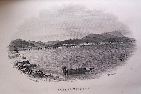 click to enlarge click to enlargeLN1E11.jpg Tipped in opposite p.104 of A Handbook of the Whitehaven and Furness Railway, by John Linton. printed at bottom left, right, centre:- "R. Shepherd delt. / W. H. Lizars sc. / DUDDON VIADUCT" item:- Armitt Library : A1158.12 Image © see bottom of page |
|
|
|
||
| hearsay:- |
There was a scheme to build an embankment across Duddon Sands, in a report by John
Hague and George Stephenson for a Cumberland coast railway route to Scotland, 1837-38;
52000 acres of land would be reclaimed. In 1867 the idea was revived, and the Furness
Railway started on work by making a cutting near Askam, quickly abandoned. |
|
|
|
||
| hearsay:- |
Timber trestle of 50 spans, 592 yards long. Replaced by cast iron about 1874. |
|
|
|
||
Lakes Guides menu.