 Old Cumbria Gazetteer
 |
 |
|
| Ghyll, Applethwaite | ||
| Ghyll | ||
| locality:- | Applethwaite | |
| civil parish:- | Underskiddaw (formerly Cumberland) | |
| county:- | Cumbria | |
| locality type:- | buildings | |
| coordinates:- | NY26592580 | |
| 1Km square:- | NY2625 | |
| 10Km square:- | NY22 | |
|
|
||
| evidence:- | old map:- OS County Series (Cmd 56 14) placename:- Gill |
|
| source data:- | Maps, County Series maps of Great Britain, scales 6 and 25
inches to 1 mile, published by the Ordnance Survey, Southampton,
Hampshire, from about 1863 to 1948. |
|
|
|
||
| evidence:- | old print:- Green 1822 (plate 30) placename:- Gill, The |
|
| source data:- | Print, uncoloured soft ground etching, The Gill in Applethwaite, Underskiddaw, Cumberland,
by William Green, Ambleside, Westmorland, 1822.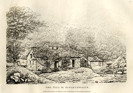 click to enlarge click to enlargeGN0830.jpg Plate 30 in Forty Etchings from Nature. printed at upper right:- "30" printed at bottom:- "THE GILL in APPLETHWAITE. / Etched from Nature by William Green, &Published at Ambleside, Feby. 1, 1822." item:- Armitt Library : A6644.30 Image © see bottom of page |
|
|
|
||
 Lakes Guides menu.