 Old Cumbria Gazetteer
 |
 |
|
| Helm, Stainton | ||
| civil parish:- | Stainton (formerly Westmorland) | |
| civil parish:- | Natland (formerly Westmorland) | |
| county:- | Cumbria | |
| locality type:- | hill | |
| coordinates:- | SD53298916 (etc) | |
| 1Km square:- | SD5389 | |
| 10Km square:- | SD58 | |
| altitude:- | 597 feet | |
| altitude:- | 182m | |
|
|
||
| evidence:- | old map:- OS County Series (Wmd 39 13) placename:- Helme |
|
| source data:- | Maps, County Series maps of Great Britain, scales 6 and 25
inches to 1 mile, published by the Ordnance Survey, Southampton,
Hampshire, from about 1863 to 1948. |
|
|
|
||
| evidence:- | descriptive text:- West 1778 (11th edn 1821) placename:- Castle Steads |
|
| source data:- | Guide book, A Guide to the Lakes, by Thomas West, published by
William Pennington, Kendal, Cumbria once Westmorland, and in
London, 1778 to 1821. goto source goto sourcePage 28:- "... [crossing Lancaster Sands] Castle-steads, a pyramidal hill, that rises above the station at Kendal, is now in sight. ..." |
|
|
|
||
| evidence:- | old map:- Garnett 1850s-60s H placename:- Helm |
|
| source data:- | Map of the English Lakes, in Cumberland, Westmorland and
Lancashire, scale about 3.5 miles to 1 inch, published by John
Garnett, Windermere, Westmorland, 1850s-60s.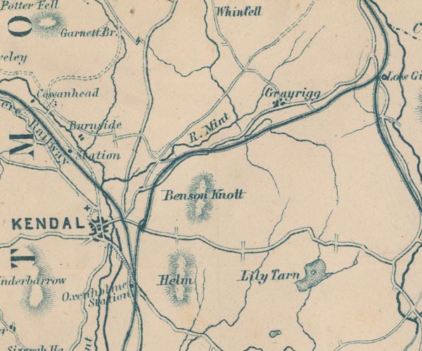 GAR2SD59.jpg "Helm" hill hachuring item:- JandMN : 82.1 Image © see bottom of page |
|
|
|
||
Lakes Guides menu.