 Old Cumbria Gazetteer
 |
 |
|
| milestone, Grayrigg | ||
| site name:- | road, Kirkby Lonsdale to Low Borrowbridge | |
| locality:- | Grayrigg Common | |
| locality:- | Dillicar | |
| civil parish:- | Grayrigg (formerly Westmorland) | |
| county:- | Cumbria | |
| locality type:- | milestone | |
| coordinates:- | SD61359887 | |
| 1Km square:- | SD6198 | |
| 10Km square:- | SD69 | |
|
|
||
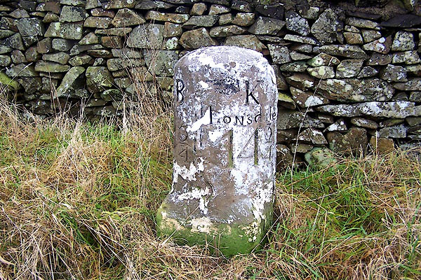 BLL25.jpg Stone, inscribed:- "B.B 1¾ / K LONSdale 14¾" (BB is Low Borrow Bridge) (taken 9.12.2005) |
||
|
|
||
| evidence:- | old map:- OS County Series (Wmd 34 8) placename:- |
|
| source data:- | Maps, County Series maps of Great Britain, scales 6 and 25
inches to 1 mile, published by the Ordnance Survey, Southampton,
Hampshire, from about 1863 to 1948. "M S Borrow Bridge 1 3/4 Kirkby Lonsdale 14 3/4" |
|
|
|
||
| evidence:- | database:- Listed Buildings 2010 |
|
| source data:- | courtesy of English Heritage "MILESTONE APPROXIMATELY 40M FROM A685 / / B6257 / GRAYRIGG / SOUTH LAKELAND / CUMBRIA / II / 75663 / SD6135498871" |
|
| source data:- | courtesy of English Heritage "Milestone. Early C19. Painted stone. Semicircular on plan, on square base with broaches to angles. Inscribed: "BB : K/LONSDALE/11/4:141/4" (BB = Borrow Bridge). Base has italic: "JM". Placed on Sedbergh to Grayrigg turnpike road, 1762." |
|
|
|
||
 Lakes Guides menu.