 Old Cumbria Gazetteer
 |
 |
|
| Millwood Junction, Barrow-in-Furness | ||
| Millwood Junction | ||
| site name:- | Furness Railway | |
| civil parish:- | Barrow-in-Furness (formerly Lancashire) | |
| county:- | Cumbria | |
| locality type:- | railway junction | |
| coordinates:- | SD21937275 (?) | |
| 1Km square:- | SD2172 | |
| 10Km square:- | SD27 | |
|
|
||
| evidence:- | old map:- OS County Series (Lan 15 16) placename:- Millwood Junction item:- railway signal |
|
| source data:- | Maps, County Series maps of Great Britain, scales 6 and 25
inches to 1 mile, published by the Ordnance Survey, Southampton,
Hampshire, from about 1863 to 1948. OS County Series (Lan 21 4) 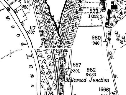 click to enlarge click to enlargeCSRY0140.jpg "Millwood Junction / S.P." |
|
|
|
||
| evidence:- | old map:- OS County Series (Lan 21) placename:- Mill Wood Junction |
|
| source data:- | Maps, County Series maps of Great Britain, scales 6 and 25
inches to 1 mile, published by the Ordnance Survey, Southampton,
Hampshire, from about 1863 to 1948. "Mill Wood Junction" |
|
|
|
||
| hearsay:- |
Branch to Yarlside Mine. |
|
|
|
||
 Lakes Guides menu.