 Old Cumbria Gazetteer
 |
 |
|
| packhorse bridge, Rosgill | ||
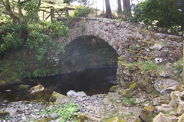
| Parish Crag Bridge | ||
| site name:- | Swindale Beck (2) | |
| locality:- | Fairy Crag | |
| locality:- | Rosgill | |
| civil parish:- | Shap Rural (formerly Westmorland) | |
| county:- | Cumbria | |
| locality type:- | packhorse bridge | |
| locality type:- | bridge | |
| coordinates:- | NY53521591 | |
| 1Km square:- | NY5315 | |
| 10Km square:- | NY51 | |
| references:- | Hinchcliffe, Ernest: 1994: Packhorse Bridges of England: Cicerone Press (Milnthorpe,
Cumbria) |
|
|
|
||
 BJT58.jpg (taken 22.8.2005) 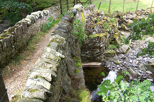 BJT59.jpg (taken 22.8.2005) |
||
|
|
||
| evidence:- | old map:- OS County Series (Wmd 14 9) placename:- Parish Crag Bridge |
|
| source data:- | Maps, County Series maps of Great Britain, scales 6 and 25
inches to 1 mile, published by the Ordnance Survey, Southampton,
Hampshire, from about 1863 to 1948. |
|
|
|
||
| evidence:- | database:- Listed Buildings 2010 placename:- Parish Crag Bridge |
|
| source data:- | courtesy of English Heritage "PARISH CRAG BRIDGE OVER SWINDALE BECK / / / SHAP RURAL / EDEN / CUMBRIA / II / 74186 / NY5352815914" |
|
| source data:- | courtesy of English Heritage "Packhorse bridge; probably C18. Arch of sandstone voussoirs with slate packing; coursed squared rubble parapet. Single segmental arch spanning c.20 ft. Pathway c.2 1/2 ft wide with c.3 ft high parapets splayed at north end." |
|
|
|
||
| :- |
27 foot span, 41 ins between parapets. |
|
| Hinchcliffe, Ernest: 1994: Packhorse Bridges of England: Cicerone Press (Milnthorpe,
Cumbria) |
||
|
|
||
 Lakes Guides menu.