 Old Cumbria Gazetteer
 |
 |
|
| Riddings Junction, Kirkandrews | ||
| Riddings Junction | ||
| site name:- | Border Union Railway | |
| locality:- | Riddings | |
| civil parish:- | Kirkandrews (formerly Cumberland) | |
| county:- | Cumbria | |
| locality type:- | railway junction | |
| coordinates:- | NY40917537 (?) | |
| 1Km square:- | NY4075 | |
| 10Km square:- | NY47 | |
|
|
||
| evidence:- | old map:- OS County Series (Cmd 6 4) |
|
| source data:- | Maps, County Series maps of Great Britain, scales 6 and 25
inches to 1 mile, published by the Ordnance Survey, Southampton,
Hampshire, from about 1863 to 1948.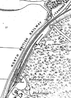 click to enlarge click to enlargeCSRY0036.jpg junction at the station, lines diverge further north |
|
|
|
||
| evidence:- | old map:- OS County Series (Cmd 6) |
|
| source data:- | Maps, County Series maps of Great Britain, scales 6 and 25
inches to 1 mile, published by the Ordnance Survey, Southampton,
Hampshire, from about 1863 to 1948. junction for 'CANOBIE BRANCH' |
|
|
|
||
| hearsay:- |
Junction for a branch to Canonbie, Langholm, etc, Scotland. |
|
|
|
||
 Lakes Guides menu.