 Old Cumbria Gazetteer
 |
 |
|
| roman fort, Brampton | ||
| civil parish:- | Brampton (formerly Cumberland) | |
| county:- | Cumbria | |
| locality type:- | roman fort | |
| locality type:- | settlement | |
| coordinates:- | NY51736131 (guess) | |
| 1Km square:- | NY5161 | |
| 10Km square:- | NY56 | |
|
|
||
| evidence:- | old map:- OS County Series |
|
| source data:- | Maps, County Series maps of Great Britain, scales 6 and 25
inches to 1 mile, published by the Ordnance Survey, Southampton,
Hampshire, from about 1863 to 1948. "Village (Site of)" |
|
|
|
||
| evidence:- | old map:- Horsley 1732 placename:- Bremelenracum placename:- Brampton |
|
| source data:- | Map, uncoloured engraving, Britannia Antiqua, roman Britain,
scale about 50 miles to 1 inch, by John Horsley, perhaps 1732,
edition published about 1869?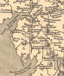 click to enlarge click to enlargeHOR1Cm.jpg "Bremelenracum / Brampton" item:- JandMN : 429 Image © see bottom of page |
|
|
|
||
 Lakes Guides menu.