 Old Cumbria Gazetteer
 |
 |
|
||||||||||||||||||||||||
| Rydal Head, Lakes | ||||||||||||||||||||||||||
| Rydal Head | ||||||||||||||||||||||||||
| locality:- | Rydal | |||||||||||||||||||||||||
| civil parish:- | Lakes (formerly Westmorland) | |||||||||||||||||||||||||
| county:- | Cumbria | |||||||||||||||||||||||||
| locality type:- | hill | |||||||||||||||||||||||||
| coordinates:- | NY36281123 (etc) | |||||||||||||||||||||||||
| 1Km square:- | NY3611 | |||||||||||||||||||||||||
| 10Km square:- | NY31 | |||||||||||||||||||||||||
|
|
||||||||||||||||||||||||||
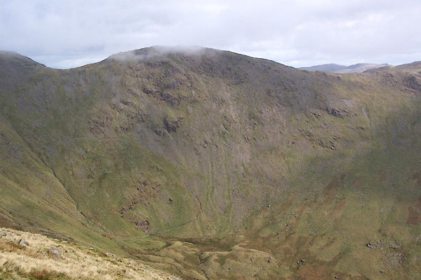 BRS44.jpg Hart Crag at the dale head. (taken 7.10.2009) |
||||||||||||||||||||||||||
|
|
||||||||||||||||||||||||||
| evidence:- | old map:- OS County Series (Wmd 19 6) placename:- Rydale Head |
|||||||||||||||||||||||||
| source data:- | Maps, County Series maps of Great Britain, scales 6 and 25
inches to 1 mile, published by the Ordnance Survey, Southampton,
Hampshire, from about 1863 to 1948. |
|||||||||||||||||||||||||
|
|
||||||||||||||||||||||||||
| evidence:- | descriptive text:- West 1778 (11th edn 1821) placename:- Rydalhead |
|||||||||||||||||||||||||
| source data:- | Guide book, A Guide to the Lakes, by Thomas West, published by
William Pennington, Kendal, Cumbria once Westmorland, and in
London, 1778 to 1821. goto source goto sourcePage 190:- "A TABLE OF THE Height of Mountains and Lakes SEEN IN THIS TOUR, ... TAKEN FROM THE LEVEL OF THE SEA. ... by Mr. John Dalton." "Rydalhead ... 1030 [yards]" goto sourceAddendum; Mr Gray's Journal, 1769 Page 211:- "..." "... Near the house [Rydal Hall] rises a huge crag, called Rydal-head, which is said to command a full view of Windermere, and I doubt it not;" goto sourcePage 212:- "for within a mile, that lake is visible even from the road; as to going up the crag, one might as well go up Skiddaw." |
|||||||||||||||||||||||||
|
|
||||||||||||||||||||||||||
| evidence:- | old text:- Camden 1789 (Gough Additions) placename:- Ridall Head |
|||||||||||||||||||||||||
| source data:- | Book, Britannia, or A Chorographical Description of the Flourishing Kingdoms of England,
Scotland, and Ireland, by William Camden, 1586, translated from the 1607 Latin edition
by Richard Gough, published London, 1789. goto source Page 155:- "..." "Ridall head in this lordship is a very high mountain, from whence in a clear day may be seen Lancaster castle and much further." |
|||||||||||||||||||||||||
|
|
||||||||||||||||||||||||||
| evidence:- | descriptive text:- Ford 1839 (3rd edn 1843) placename:- Rydal Head item:- altitude, Rydal Head |
|||||||||||||||||||||||||
| source data:- | Guide book, A Description of Scenery in the Lake District, by
Rev William Ford, published by Charles Thurnam, Carlisle, by W
Edwards, 12 Ave Maria Lane, Charles Tilt, Fleet Street, William
Smith, 113 Fleet Street, London, by Currie and Bowman,
Newcastle, by Bancks and Co, Manchester, by Oliver and Boyd,
Edinburgh, and by Sinclair, Dumfries, 1839. goto source Page 178:- "ELEVATION OF THE MOUNTAINS," "ACCORDING TO DIFFERENT AUTHORITIES."
|
|||||||||||||||||||||||||
|
|
||||||||||||||||||||||||||
| evidence:- | old map:- Ford 1839 map placename:- Rydal Head |
|||||||||||||||||||||||||
| source data:- | Map, uncoloured engraving, Map of the Lake District of
Cumberland, Westmoreland and Lancashire, scale about 3.5 miles
to 1 inch, published by Charles Thurnam, Carlisle, and by R
Groombridge, 5 Paternoster Row, London, 3rd edn 1843.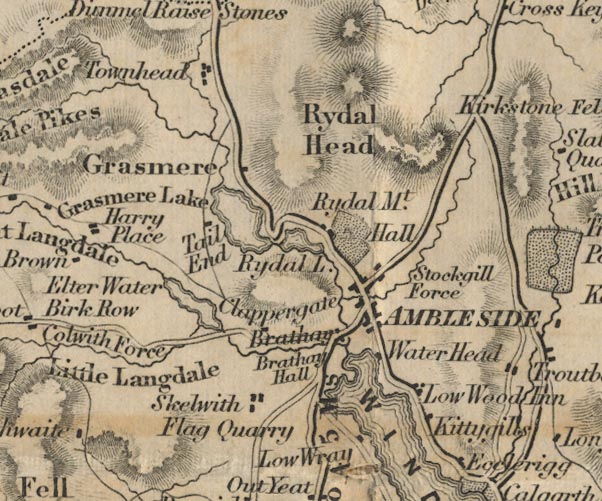 FD02NY30.jpg "Rydal Head" Hill hachuring. item:- JandMN : 100.1 Image © see bottom of page |
|||||||||||||||||||||||||
|
|
||||||||||||||||||||||||||
| evidence:- | outline view:- Martineau 1855 |
|||||||||||||||||||||||||
| source data:- | Print, engraving, outline view, Mountains seen on the Keswick Road approaching Ullswater,
drawn by L Aspland, engraved by W Banks, Edinburgh, published by John Garnett, Windermere,
Westmorland, and by Whittaker and Co, London, 1855.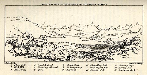 click to enlarge click to enlargeMNU115.jpg Opposite p.104 in A Complete Guide to the English Lakes, by Harriet Martineau. "MOUNTAINS SEEN ON THE KESWICK ROAD APPROACHING ULLSWATER." "L Aspland Delt. / W Banks Sc Edinr." The view is captioned, numbers referring to mountains in the image:- "1 Place Fell, 2 Birk Fell, 3 Red Screes, 4 Scandale Head, 5 Dove Crag (Hartsop), 6 Birks, 7 Rydal Head, 8 St. Sundays Crag, 9, Fairfield, 10 Glenridding Dod, 11 Dolly Waggon Pike, 12 Bleaberry Fell, 13 Striding Edge, 14 Herring Pike, 15 Gowbarrow Park." item:- Armitt Library : A1159.15 Image © see bottom of page |
|||||||||||||||||||||||||
|
|
||||||||||||||||||||||||||
| evidence:- | old text:- Martineau 1855 item:- altitude, Rydal Head |
|||||||||||||||||||||||||
| source data:- | Guide book, A Complete Guide to the English Lakes, by Harriet
Martineau, published by John Garnett, Windermere, Westmorland,
and by Whittaker and Co, London, 1855; published 1855-76. goto source Page 179:- "A TABLE OF THE HEIGHTS OF MOUNTAINS IN THE COUNTIES OF CUMBERLAND, WESTMORLAND, AND LANCASHIRE." "No. : Names of Mountains. : Counties. : Height in Feet above the Sea Level." "8 : Rydal Head : Westmorland : 2910" |
|||||||||||||||||||||||||
|
|
||||||||||||||||||||||||||
| evidence:- | old drawing:- Brockbank 1870s placename:- Rydal Head |
|||||||||||||||||||||||||
| source data:- | Drawing, ink, mammilated rock, roche moutonnee, near Mirror Pool, Rydal Head, Rydal,
Westmorland, by WH, 1872, used by William Brockbank.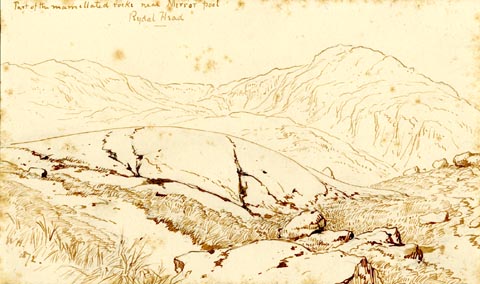 click to enlarge click to enlargePR1928.jpg "Part of the mammilated rocks near Mirror pool / Rydal Head" "WH. / 1872." "Glaciated Rock: Rydal Head / W Brock[ ] / 23" "In Rydale, which descends from Fairfield to the Rydal Valley, are some of the finest examples of / Ice worn or mammilated Rocks, to be seen in / the Lake district. They lie in the [mid] valley & / have evidently been ground away by the glacier / which filled the valley & formed its huge [ ] / [ ] There are no good examples of / Moraines in Rydale, the valley was apparently / too steep for them but the perched rocks are / frequent & very fine" item:- Armitt Library : 1959.68.23 Image © see bottom of page |
|||||||||||||||||||||||||
|
|
||||||||||||||||||||||||||
| evidence:- | outline view:- Black 1856 (23rd edn 1900) placename:- Rydal Head |
|||||||||||||||||||||||||
| source data:- | Print, lithograph, Outline Views, Windermere - Mountains as seen from the North End
of Belle Isle, Windermere, and Mountains as seen from Biscay How, Bowness, by J Flintoft,
Keswick, Cumberland, engraved by R Mason, Edinburgh, Lothian, about 1900.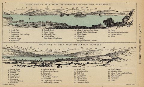 click to enlarge click to enlargeBC08E1.jpg "... 6 Rydal Head ... 21 Rydal Head ..." item:- JandMN : 37.4 Image © see bottom of page |
|||||||||||||||||||||||||
|
|
||||||||||||||||||||||||||
| evidence:- | outline view:- Black 1841 (3rd edn 1846) placename:- Rydal Head |
|||||||||||||||||||||||||
| source data:- | Print, engraving, outline view, Mountains as seen from the North End of Belle Isle,
Windermere, and Mountains as seen from Bisket How, Bowness, by J Flintoft, Keswick,
Cumberland, engraved by R Mason, Edinburgh, about 1844.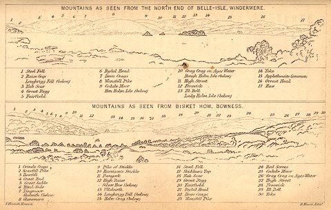 click to enlarge click to enlargeBC02E1.jpg "... 6 Rydal Head ... 21 Rydal Head ..." item:- JandMN : 32.3 Image © see bottom of page |
|||||||||||||||||||||||||
|
|
||||||||||||||||||||||||||
| evidence:- | outline view:- Tattersall 1836 placename:- Rydal Head |
|||||||||||||||||||||||||
| source data:- | Print, engraving, Rydal Water, from the South East, Westmorland, drawn by George Tattersall,
engraved by W F Topham, published by Sherwood and Co, Paternoster Row, London, about
1836.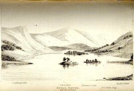 click to enlarge click to enlargeTAT111.jpg The print is captioned with mountain names and acts as an outline view. Tipped in opposite p.44 of The Lakes of England, by George Tattersall. printed at bottom:- "RYDAL WATER, / from the South East." printed at bottom left to right:- "Loughrigg Fell. / Silver How. / Hammar Scarr. / Pt. of Helm Crag. / Rydal Head." item:- Armitt Library : A1204.12 Image © see bottom of page |
|||||||||||||||||||||||||
|
|
||||||||||||||||||||||||||
Lakes Guides menu.