 Old Cumbria Gazetteer
 |
 |
|
||||||||||||||||||||||||
| Rydal Water | ||||||||||||||||||||||||||
| runs into:- |  Rothay, River Rothay, River |
|||||||||||||||||||||||||
|
|
||||||||||||||||||||||||||
| civil parish:- | Lakes (formerly Westmorland) | |||||||||||||||||||||||||
| county:- | Cumbria | |||||||||||||||||||||||||
| locality type:- | lake | |||||||||||||||||||||||||
| coordinates:- | NY35540619 (etc) | |||||||||||||||||||||||||
| 1Km square:- | NY3506 | |||||||||||||||||||||||||
| 10Km square:- | NY30 | |||||||||||||||||||||||||
|
|
||||||||||||||||||||||||||
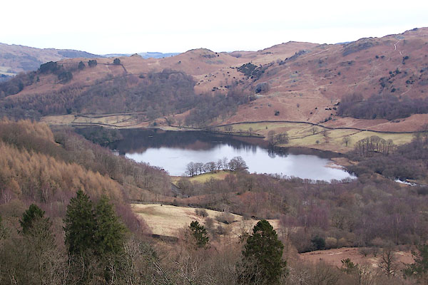 BSF83.jpg (taken 2.3.2010) 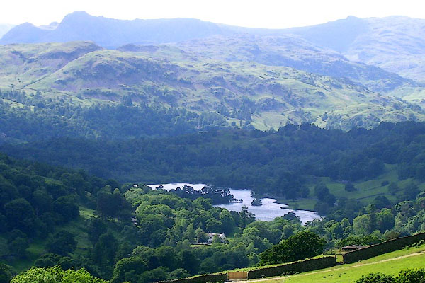 BPH75.jpg From SE. (taken 9.6.2008) |
||||||||||||||||||||||||||
|
|
||||||||||||||||||||||||||
| evidence:- | old map:- OS County Series (Wmd 26 1) placename:- Rydal Water |
|||||||||||||||||||||||||
| source data:- | Maps, County Series maps of Great Britain, scales 6 and 25
inches to 1 mile, published by the Ordnance Survey, Southampton,
Hampshire, from about 1863 to 1948. |
|||||||||||||||||||||||||
|
|
||||||||||||||||||||||||||
| evidence:- | old map:- Saxton 1579 |
|||||||||||||||||||||||||
| source data:- | Map, hand coloured engraving, Westmorlandiae et Cumberlandiae Comitatus ie Westmorland
and Cumberland, scale about 5 miles to 1 inch, by Christopher Saxton, London, engraved
by Augustinus Ryther, 1576, published 1579-1645.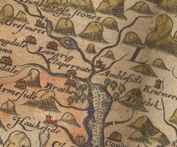 Sax9NY30.jpg Lake and island. item:- private collection : 2 Image © see bottom of page |
|||||||||||||||||||||||||
|
|
||||||||||||||||||||||||||
| evidence:- | old map:- Mercator 1595 (edn?) placename:- |
|||||||||||||||||||||||||
| source data:- | Map, hand coloured engraving, Westmorlandia, Lancastria, Cestria
etc, ie Westmorland, Lancashire, Cheshire etc, scale about 10.5
miles to 1 inch, by Gerard Mercator, Duisberg, Germany, 1595,
edition 1613-16. MER5WmdA.jpg "" outline, coast shaded, tinted blue; lake, shown together with Grasmere item:- Armitt Library : 2008.14.3 Image © see bottom of page |
|||||||||||||||||||||||||
|
|
||||||||||||||||||||||||||
| evidence:- | probably old map:- Jansson 1646 |
|||||||||||||||||||||||||
| source data:- | Map, hand coloured engraving, Cumbria and Westmoria, ie
Cumberland and Westmorland, scale about 3.5 miles to 1 inch, by
John Jansson, Amsterdam, Netherlands, 1646.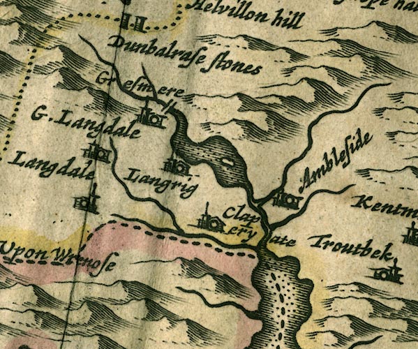 JAN3NY30.jpg Outline with shore shaded, dotted area; it includes Grasmere lake? item:- JandMN : 88 Image © see bottom of page |
|||||||||||||||||||||||||
|
|
||||||||||||||||||||||||||
| evidence:- | old map:- Ogilby 1675 (plate 96) |
|||||||||||||||||||||||||
| source data:- | Road strip map, hand coloured engraving, the Road from Kendal to
Cockermouth, and the Road from Egremond to Carlisle, scale about
1 inch to 1 mile, by John Ogilby, London, 1675.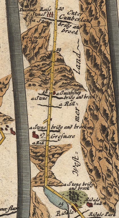 OG96m015.jpg In mile 15, Westmerland. Lake close on the left of the road. item:- JandMN : 22 Image © see bottom of page |
|||||||||||||||||||||||||
|
|
||||||||||||||||||||||||||
| evidence:- | old map:- Seller 1694 (Wmd) |
|||||||||||||||||||||||||
| source data:- | Map, hand coloured engraving, Westmorland, scale about 8 miles
to 1 inch, by John Seller, 1694. click to enlarge click to enlargeSEL7.jpg outline with shaded shore; lake; with Grasmere lake item:- Dove Cottage : 2007.38.87 Image © see bottom of page |
|||||||||||||||||||||||||
|
|
||||||||||||||||||||||||||
| evidence:- | old map:- Morden 1695 (Cmd) |
|||||||||||||||||||||||||
| source data:- | Map, uncoloured engraving, Cumberland, scale about 4 miles to 1
inch, by Robert Morden, 1695, published by Abel Swale, the
Unicorn, St Paul's Churchyard, Awnsham, and John Churchill, the
Black Swan, Paternoster Row, London, 1695-1715.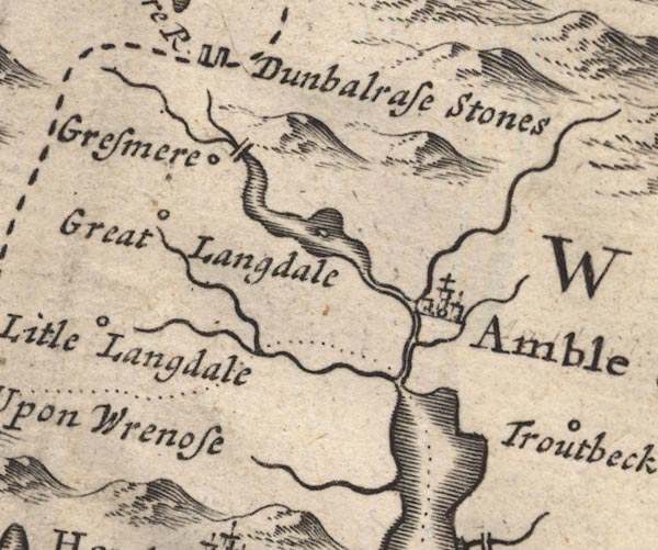 MD12NY30.jpg Outline with shore shading, single area for two lakes, between Grasmere and Ambleside, with an island. item:- JandMN : 90 Image © see bottom of page |
|||||||||||||||||||||||||
|
|
||||||||||||||||||||||||||
| evidence:- | old map:- Morden 1695 (Wmd) |
|||||||||||||||||||||||||
| source data:- | Map, hand coloured engraving, Westmorland, scale about 2.5 miles to 1 inch, by Robert
Morden, published by Abel Swale, the Unicorn, St Paul's Churchyard, Awnsham, and John
Churchill, the Black Swan, Paternoster Row, London, 1695.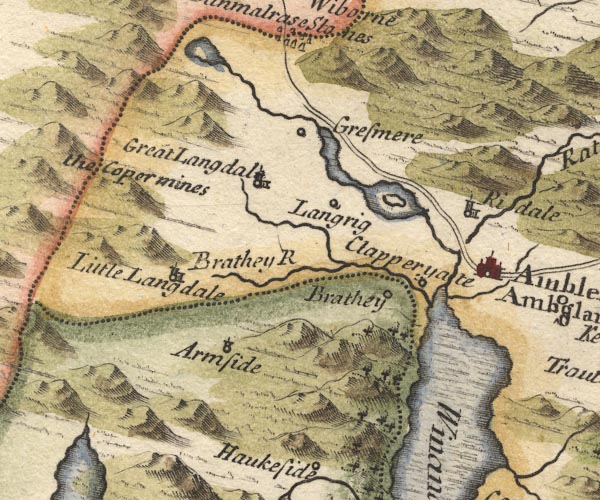 MD10NY30.jpg Outline with shore shading, tinted blue, with an island. item:- JandMN : 24 Image © see bottom of page |
|||||||||||||||||||||||||
|
|
||||||||||||||||||||||||||
| evidence:- | perhaps old map:- Badeslade 1742 placename:- |
|||||||||||||||||||||||||
| source data:- | Map, uncoloured engraving, A Map of Westmorland North from
London, scale about 10 miles to 1 inch, with descriptive text,
by Thomas Badeslade, London, engraved and published by William
Henry Toms, Union Court, Holborn, London, 1742. click to enlarge click to enlargeBD12.jpg "" outline with form lines item:- Dove Cottage : 2007.38.62 Image © see bottom of page |
|||||||||||||||||||||||||
|
|
||||||||||||||||||||||||||
| evidence:- | old map:- Simpson 1746 map (Wmd) |
|||||||||||||||||||||||||
| source data:- | Map, uncoloured engraving, Westmorland, scale about 8 miles to 1
inch, printed by R Walker, Fleet Lane, London, 1746.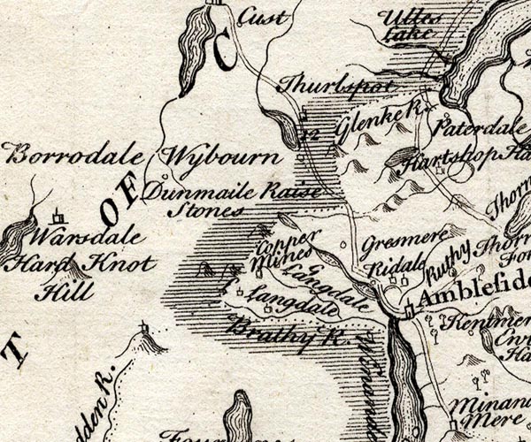 SMP2NYF.jpg Outline with form lines. item:- Dove Cottage : 2007.38.59 Image © see bottom of page |
|||||||||||||||||||||||||
|
|
||||||||||||||||||||||||||
| evidence:- | old map:- Bowen and Kitchin 1760 |
|||||||||||||||||||||||||
| source data:- | Map, hand coloured engraving, A New Map of the Counties of
Cumberland and Westmoreland Divided into their Respective Wards,
scale about 4 miles to 1 inch, by Emanuel Bowen and Thomas
Kitchin et al, published by T Bowles, Robert Sayer, and John
Bowles, London, 1760.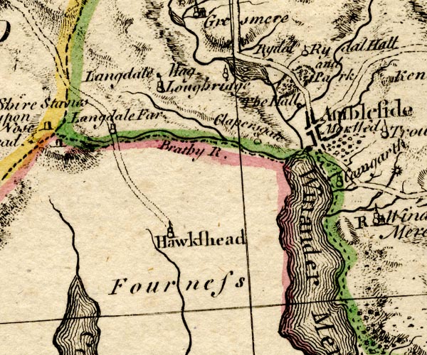 BO18SD29.jpg outline with form lines item:- Armitt Library : 2008.14.10 Image © see bottom of page |
|||||||||||||||||||||||||
|
|
||||||||||||||||||||||||||
| evidence:- | old map:- Jefferys 1770 (Wmd) |
|||||||||||||||||||||||||
| source data:- | Map, 4 sheets, The County of Westmoreland, scale 1 inch to 1
mile, surveyed 1768, and engraved and published by Thomas
Jefferys, London, 1770. J5NY30NE.jpg outline with form lines; lake or tarn item:- National Library of Scotland : EME.s.47 Image © National Library of Scotland |
|||||||||||||||||||||||||
|
|
||||||||||||||||||||||||||
| evidence:- | descriptive text:- West 1778 (11th edn 1821) |
|||||||||||||||||||||||||
| source data:- | Guide book, A Guide to the Lakes, by Thomas West, published by
William Pennington, Kendal, Cumbria once Westmorland, and in
London, 1778 to 1821. goto source Page 80:- "..." "RYDAL-WATER," "A lake about a mile in length, spotted with little isles, and which communicates, by a narrow channel, with" "GRASMERE-WATER," "The river Rothay is their common outlet." "..." goto sourcePage 190:- "A TABLE OF THE Height of Mountains and Lakes SEEN IN THIS TOUR, ... TAKEN FROM THE LEVEL OF THE SEA. ... by Mr. John Dalton." "Rydal-water ... 52 [yards]" goto sourceAddendum; Mr Gray's Journal, 1769 Page 211:- "..." "... Rydal-water, another small lake, but of inferior size and beauty: it seems shallow too, for large patches of reeds appear pretty far within. ..." goto sourceRev Plumtre's Night Piece on Windermere, 1797 Page 232:- "[the Rothay] Through Rydal's lake, with placid stream, / You, murmuring, in the valley gleam; / ..." |
|||||||||||||||||||||||||
|
|
||||||||||||||||||||||||||
| evidence:- | old map:- West 1784 map placename:- Rydal Water |
|||||||||||||||||||||||||
| source data:- | Map, hand coloured engraving, A Map of the Lakes in Cumberland,
Westmorland and Lancashire, scale about 3.5 miles to 1 inch,
engraved by Paas, 53 Holborn, London, about 1784.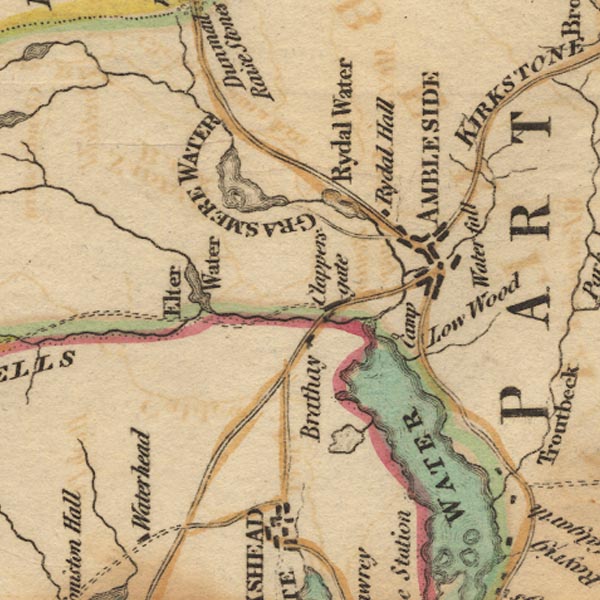 Ws02NY30.jpg item:- Armitt Library : A1221.1 Image © see bottom of page |
|||||||||||||||||||||||||
|
|
||||||||||||||||||||||||||
| evidence:- | old text:- Clarke 1787 placename:- Rydale Water placename:- Rydall Water |
|||||||||||||||||||||||||
| source data:- | Guide book, A Survey of the Lakes of Cumberland, Westmorland,
and Lancashire, written and published by James Clarke, Penrith,
Cumberland, and in London etc, 1787; published 1787-93. goto source Page 125:- "..." "... Rydale or Rydall-Water. This is a pretty little Lake three quarters of a mile long, spotted beautifully with little islands, and surrounded with broken stupendous mountains. ..." "This little Lake affords two or three very good views: Mr Farrington has made choice of one from the low end, which I do not much admire, as the station is rather too low; but Mr Hannan took two others, which I like better. I, however, already described so many that I will leave the traveller chuse for himself, and those who may read this, and not travel, have already had enough of description: let it suffice then to say, that this Lake hath several little islands upon it, and is surrounded with woods and mountains, and that the largest island is covered with wood, and has a small house upon it, so that we have variety enough; but there is not one station where the landscape closes, both on the right and the left." |
|||||||||||||||||||||||||
|
|
||||||||||||||||||||||||||
| evidence:- | old map:- Clarke 1787 map (Ambleside to Keswick) placename:- Rydale Water |
|||||||||||||||||||||||||
| source data:- | Map, A Map of the Roads Lakes etc between Keswick and Ambleside,
scale about 2.5 ins to 1 mile, by James Clarke, engraved by S J
Neele, 352 Strand, published by James Clarke, Penrith,
Cumberland and in London etc, 1787. CL9NY30N.jpg "Rydale Water" item:- private collection : 10.9 Image © see bottom of page |
|||||||||||||||||||||||||
|
|
||||||||||||||||||||||||||
| evidence:- | old map:- Cary 1789 (edn 1805) |
|||||||||||||||||||||||||
| source data:- | Map, uncoloured engraving, Westmoreland, scale about 2.5 miles
to 1 inch, by John Cary, London, 1789; edition 1805. CY24NY30.jpg outline with shore form lines; lake or tarn item:- JandMN : 129 Image © see bottom of page |
|||||||||||||||||||||||||
|
|
||||||||||||||||||||||||||
| evidence:- | old print:- Farington 1789 placename:- Rydal Mere |
|||||||||||||||||||||||||
| source data:- | Print, uncoloured engraving, Rydal Mere, Westmorland, drawn by Joseph Farington, engraved
by B T Pouncy, published by William Byrne, 79 Titchfield Street, London, 1785.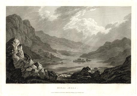 click to enlarge click to enlargeFA0306.jpg printed, bottom left, right, centre "Drawn by J. Farington. / Etcht by B. T. Pouncy / RYDAL MERE. / London: Published as the Act directs, 1 March 1785, by W. Byrne, No 79, Titchfield Street." item:- Armitt Library : A6668.6 Image © see bottom of page |
|||||||||||||||||||||||||
|
|
||||||||||||||||||||||||||
| evidence:- | old drawing:- Green 1790s-1820s (1807) placename:- Rydal Water |
|||||||||||||||||||||||||
| source data:- | Drawing, pencil, Rydal Water from Rydal Park, Rydal, Westmorland, by William Green,
Ambleside, Westmorland, 31 August 1807.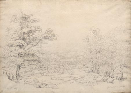 click to enlarge click to enlargePR1757.jpg ms, pencil at lower left, right:- "Augt 31 1807 / Rydal Water from Rydal Park" item:- Dove Cottage : B44 Image © see bottom of page |
|||||||||||||||||||||||||
|
|
||||||||||||||||||||||||||
| evidence:- | old print:- Smith 1795 placename:- Rydal Lake |
|||||||||||||||||||||||||
| source data:- | Print uncoloured engraving, with some aquatint, Rydal Lake, Westmorland, drawn by
John 'Warwick' Smith, engraved by F Merigot, published by R Blamire, Strand, London,
1795.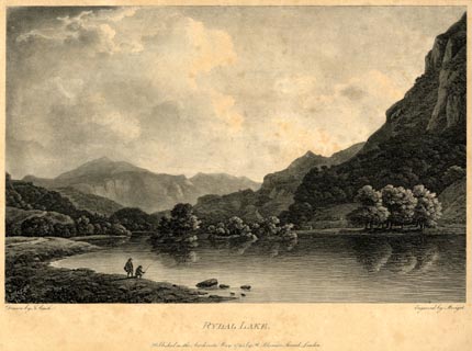 click to enlarge click to enlargePR1853.jpg printed, bottom left, right, centre "Drawn by J. Smith. / Engraved by Merigot. / RYDAL LAKE. / Published as the Act directs, May, 1795, by Rd. Blamire, Strand, London." item:- Armitt Library : 2011.68 Image © see bottom of page |
|||||||||||||||||||||||||
|
|
||||||||||||||||||||||||||
| evidence:- | old map:- Housman 1800 map 4 placename:- Rydal Water |
|||||||||||||||||||||||||
| source data:- | Maps, hand coloured engraving, Lakes in Lancashire and Westmorland, 7 lakes on one
sheet, engraved by McIntyre, Edinburgh, published by F Jollie, Carlisle, Cumberland,
and C Law, Ave Maria Lane, London, 1800.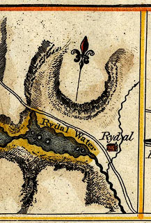 click to enlarge click to enlargeHM02Ryd.jpg "Rydal Water" item:- Dove Cottage : 2007.38.97 Image © see bottom of page |
|||||||||||||||||||||||||
|
|
||||||||||||||||||||||||||
| evidence:- | old map:- Cooke 1802 |
|||||||||||||||||||||||||
| source data:- | Map, The Lakes, Westmorland and Cumberland, scale about 8.5
miles to 1 inch, engravedby Neele and Son, published by
Sherwood, Jones and Co, Paternoster Road, London, 1824. click to enlarge click to enlargeGRA1Lk.jpg outline with form lines; lake or tarn item:- Hampshire Museums : FA2000.62.5 Image © see bottom of page |
|||||||||||||||||||||||||
|
|
||||||||||||||||||||||||||
| evidence:- | old map:- Cooke 1802 |
|||||||||||||||||||||||||
| source data:- | Map, Westmoreland ie Westmorland, scale about 12 miles to 1
inch, by George Cooke, 1802, published by Sherwood, Jones and
Co, Paternoster Road, London, 1824. click to enlarge click to enlargeGRA1Wd.jpg outline with form lines; lake or tarn item:- Hampshire Museums : FA2000.62.4 Image © see bottom of page |
|||||||||||||||||||||||||
|
|
||||||||||||||||||||||||||
| evidence:- | old print:- Green 1804 (plate 7) placename:- Rydal Water |
|||||||||||||||||||||||||
| source data:- | Print, uncoloured aquatint, Rydal Water, taken under Loughrigg Fell, Westmorland,
by William Green, Ambleside, Westmorland, 1804.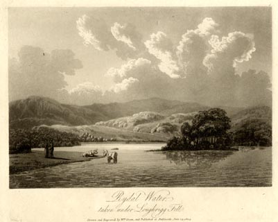 click to enlarge click to enlargeGN1607.jpg Plate 7 from a series. printed at bottom:- "Rydal Water, / taken under Loughrigg Fell. / Drawn and Engraved by Wm. Green, and Published at Ambleside, June 24, 1804." printed at top right:- "7" item:- Armitt Library : 2014.149 Image © see bottom of page |
|||||||||||||||||||||||||
|
|
||||||||||||||||||||||||||
| evidence:- | old map:- Laurie and Whittle 1806 placename:- Rydal Water |
|||||||||||||||||||||||||
| source data:- | Road map, Completion of the Roads to the Lakes, scale about 10
miles to 1 inch, by Nathaniel Coltman? 1806, published by Robert
H Laurie, 53 Fleet Street, London, 1834. click to enlarge click to enlargeLw18.jpg "Rydal Water" lake item:- private collection : 18.18 Image © see bottom of page |
|||||||||||||||||||||||||
|
|
||||||||||||||||||||||||||
| evidence:- | old map:- Cooper 1808 |
|||||||||||||||||||||||||
| source data:- | Map, hand coloured engraving, Westmoreland ie Westmorland, scale
about 9 miles to 1 inch, by H Cooper, 1808, published by R
Phillips, Bridge Street, Blackfriars, London, 1808. click to enlarge click to enlargeCOP4.jpg outline, shaded; lake item:- Dove Cottage : 2007.38.53 Image © see bottom of page |
|||||||||||||||||||||||||
|
|
||||||||||||||||||||||||||
| evidence:- | old print:- Green 1810 (plate 21) placename:- Rydal Water |
|||||||||||||||||||||||||
| source data:- | Print, soft ground etching, Rydal Water from Rydal Park, Westmorland, by William Green,
Ambleside, Westmorland, 1810.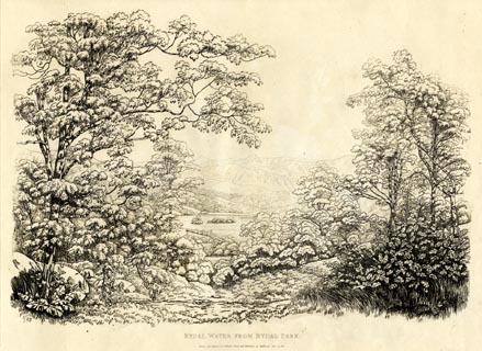 click to enlarge click to enlargeGN1221.jpg Plate 21 in Sixty Studies from Nature, 1810. printed at top right:- "21" printed at bottom:- "RYDAL WATER FROM RYDAL PARK. / Drawn and Engraved by William Green and Published at Ambleside, June 24, 1810." watermark:- "J WHATMAN / 1813" item:- Armitt Library : A6641.21 Image © see bottom of page |
|||||||||||||||||||||||||
|
|
||||||||||||||||||||||||||
| evidence:- | old text:- Wordsworth 1810 item:- storm |
|||||||||||||||||||||||||
| source data:- | Guide book, A Description of the Scenery of the Lakes, later A
Guide through the District of The Lakes, by William Wordsworth,
1810-35. goto source page 110 "... On this day, March 30, 1822, the winds have been acting upon the small Lake of Rydal, as if they had received command to carry its waters from their bed into the sky; the white billows in different quarters disappeared under clouds, or rather" goto sourcepage 111 "drifts, of spray, that were whirled along, and up into the air by scouring winds, charging each other in squadrons in every direction, upon the Lake. The spray, having been hurried aloft till it lost its consistency and whiteness, was driven along the mountain tops like flying showers that vanish in the distance. Freduently (sic) an eddying wind scooped the waters out of the basin, and forced them upwards in the very shape of an Icelandic Geyser, or boiling fountain, to the height of several hundred feet." "..." |
|||||||||||||||||||||||||
|
|
||||||||||||||||||||||||||
| evidence:- | old print:- Green 1814 (plate 19) placename:- Rydal Water |
|||||||||||||||||||||||||
| source data:- | Print, uncoloured soft ground etching, Rydal Water, Rydal, Westmorland, by William
Green, Ambleside, Westmorland, 1814.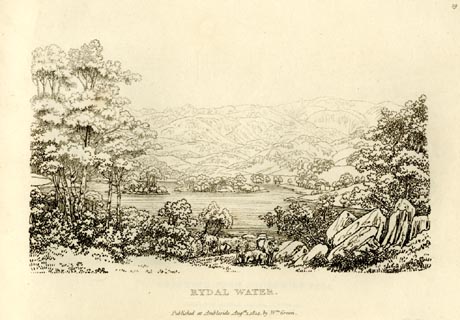 click to enlarge click to enlargeGN0919.jpg Plate 19 in Sixty Small Prints. printed at top right:- "19" printed at bottom:- "RYDAL WATER. / Published at Ambleside Augst. 1, 1814, by Wm. Green." item:- Armitt Library : A6656.19 Image © see bottom of page |
|||||||||||||||||||||||||
|
|
||||||||||||||||||||||||||
| evidence:- | old print:- Green 1814 (plate 19) placename:- Rydal Water |
|||||||||||||||||||||||||
| source data:- | Print, tinted soft ground etching, Rydal Water, Rydal, Westmorland, by William Green,
Ambleside, Westmorland, 1814.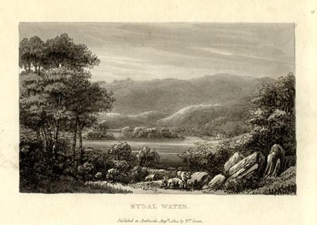 click to enlarge click to enlargeGN1019.jpg Plate 19 in Sixty Small Prints. printed at top right:- "19" printed at bottom:- "RYDAL WATER. / Published at Ambleside Augst. 1, 1814, by Wm. Green." item:- Armitt Library : A6653.19 Image © see bottom of page |
|||||||||||||||||||||||||
|
|
||||||||||||||||||||||||||
| evidence:- | old print:- Green 1815 placename:- Rydal Water item:- sheep |
|||||||||||||||||||||||||
| source data:- | Print, coloured aquatint, Rydal Water, Rydal, Westmorland, by William Green, Ambleside,
Westmorland, 1815.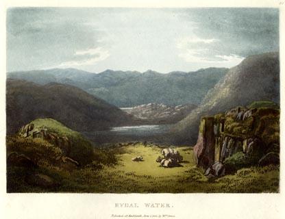 click to enlarge click to enlargeGN0526.jpg Plate 28 in Lake Scenery. printed at upper right:- "28" printed at bottom:- "RYDAL WATER. / Published at Ambleside, June 1, 1815, by Wm. Green." item:- Armitt Library : A6646.26 Image © see bottom of page |
|||||||||||||||||||||||||
|
|
||||||||||||||||||||||||||
| evidence:- | old map:- Otley 1818 |
|||||||||||||||||||||||||
| source data:- | Map, uncoloured engraving, The District of the Lakes,
Cumberland, Westmorland, and Lancashire, scale about 4 miles to
1 inch, by Jonathan Otley, 1818, engraved by J and G Menzies,
Edinburgh, Scotland, published by Jonathan Otley, Keswick,
Cumberland, et al, 1833. OT02NY30.jpg item:- JandMN : 48.1 Image © see bottom of page |
|||||||||||||||||||||||||
|
|
||||||||||||||||||||||||||
| evidence:- | old print:- Fielding and Walton 1821 (plate 19) placename:- Rydal Water |
|||||||||||||||||||||||||
| source data:- | Print, coloured aquatint, Rydal Water, Westmorland, drawn by John Walton, published
by R Ackermann, 101 Strand, London, 1821. click to enlarge click to enlargeFW0119.jpg Tipped in opposite p.94 in A Picturesque Tour of the English Lakes. item:- Dove Cottage : 1993.R566.19 Image © see bottom of page |
|||||||||||||||||||||||||
|
|
||||||||||||||||||||||||||
| evidence:- | old print:- Fielding and Walton 1821 (plate 20) placename:- Rydal Water |
|||||||||||||||||||||||||
| source data:- | Print, coloured aquatint, Rydal Water, from White Moss, Westmorland, drawn by John
Walton, published by R Ackermann, 101 Strand, London, 1821.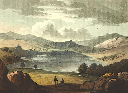 click to enlarge click to enlargeFW0120.jpg Tipped in opposite p.104 in A Picturesque Tour of the English Lakes. item:- Dove Cottage : 1993.R566.20 Image © see bottom of page |
|||||||||||||||||||||||||
|
|
||||||||||||||||||||||||||
| evidence:- | descriptive text:- Otley 1823 (5th edn 1834) item:- heronry; fishing; pike; perch; eel; trout |
|||||||||||||||||||||||||
| source data:- | Guide book, A Concise Description of the English Lakes, the
mountains in their vicinity, and the roads by which they may be
visited, with remarks on the mineralogy and geology of the
district, by Jonathan Otley, published by the author, Keswick,
Cumberland now Cumbria, by J Richardson, London, and by Arthur
Foster, Kirkby Lonsdale, Cumbria, 1823; published 1823-49,
latterly as the Descriptive Guide to the English Lakes. goto source Page 14:- "RYDAL WATER" "Is of smaller dimensions [than Grasmere], and formed in a more contracted part of the valley; it receives the river flowing from Grasmere lake after a course of about half a mile. It is ornamented by two picturesque islands, on one of which the herons build their nests in the trees; and it is bordered by meadows and woody grounds, surmounted on one side by the precipitous rocks of Nab Scar, and on the other by the steeps of Loughrigg Fell." "The fish in Grasmere and Rydal Waters, are pike, perch, (provincially called bass,) and eels, with a few trout." |
|||||||||||||||||||||||||
|
|
||||||||||||||||||||||||||
| evidence:- | old map:- Leigh 1830 map |
|||||||||||||||||||||||||
| source data:- | Map, Grasmere Rydal and Langdale, scale about 1.5 miles to 1
inch, engraved by Josiah Neele, 352 Strand, published by Leigh
and Son, 421 Strand, London, about 1830.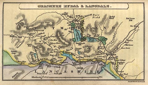 click to enlarge click to enlargeLE04.jpg item:- JandMN : 1.3 Image © see bottom of page |
|||||||||||||||||||||||||
|
|
||||||||||||||||||||||||||
| evidence:- | old print:- Westall 1830s placename:- Rydal Lake |
|||||||||||||||||||||||||
| source data:- | Print, aquatint panorama, Rydal, from Mr Wordsworth's Field under Rydal Mount, Westmorland,
drawn and engraved by William Westall, published by R Ackermann, 96 Strand, London,
1830s.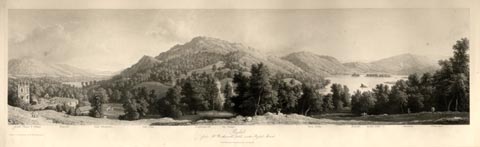 click to enlarge click to enlargeWTL309.jpg "Rydal Chapel & Village. Wansfell. Lake Windermere. Gate Crag. Loughrigg fell. Ivy Cottage. River Rotha. Bowfell. Rydal Lake. Silverhow. White moss. / Drawn & Engraved by W. Westall A.R.A. / Rydal, from Mr Wordsworth's field under Rydal Mount. / Published by R. Ackermann, 96 Strand." item:- Armitt Library : A6658.9 Image © see bottom of page |
|||||||||||||||||||||||||
|
|
||||||||||||||||||||||||||
| evidence:- | descriptive text:- Ford 1839 (3rd edn 1843) placename:- Rydal Water item:- depth, Rydal Water |
|||||||||||||||||||||||||
| source data:- | Guide book, A Description of Scenery in the Lake District, by
Rev William Ford, published by Charles Thurnam, Carlisle, by W
Edwards, 12 Ave Maria Lane, Charles Tilt, Fleet Street, William
Smith, 113 Fleet Street, London, by Currie and Bowman,
Newcastle, by Bancks and Co, Manchester, by Oliver and Boyd,
Edinburgh, and by Sinclair, Dumfries, 1839. goto source Page 41:- "..." "RYDAL WATER" "Is a small lake, two miles from Ambleside, about one mile long, and half a mile broad, and surrounded closely on all sides by lofty fells. The shores are picturesque, having a rocky promontory here and there, and bays in which the reeds wave over the floating flowers of the lily. The wooded islets add to its beauty. Pike, perch, eel, and trout, are found in its waters, which have been at different times the graves of rash and thoughtless skaters." goto sourcePage 163:- "..." "Rydal Water is one of the smallest of the lakes, but very beautiful from its wooded islands and shores, which give it an air of great seclusion.- (See page 41.)" goto sourcePage 177:- "A TABLE" "OF THE LENGTH, BREADTH, &c. OF THE LAKES," "COLLECTED FROM DIFFERENT AUTHORITIES."
|
|||||||||||||||||||||||||
|
|
||||||||||||||||||||||||||
| evidence:- | old map:- Ford 1839 map placename:- Rydal Lake |
|||||||||||||||||||||||||
| source data:- | Map, uncoloured engraving, Map of the Lake District of
Cumberland, Westmoreland and Lancashire, scale about 3.5 miles
to 1 inch, published by Charles Thurnam, Carlisle, and by R
Groombridge, 5 Paternoster Row, London, 3rd edn 1843.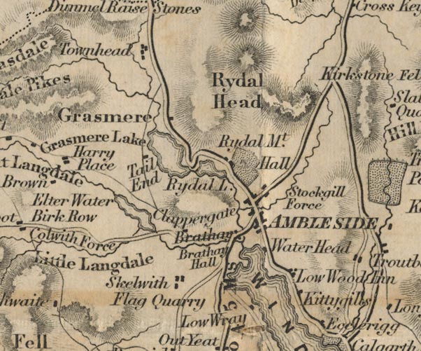 FD02NY30.jpg "Rydal L." Outline with form lines. item:- JandMN : 100.1 Image © see bottom of page |
|||||||||||||||||||||||||
|
|
||||||||||||||||||||||||||
| evidence:- | old drawing:- Aspland 1840s-60s placename:- Rydal Water |
|||||||||||||||||||||||||
| source data:- | Drawing, pencil, Rydal Water, Westmorland, by Theophilus Lindsey Aspland, 1857.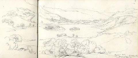 click to enlarge click to enlargeAS0507.jpg "Rydal Wr / going from Red Bank / to Ambleside" page number "6" item:- Armitt Library : 1958.389.7 Image © see bottom of page |
|||||||||||||||||||||||||
|
|
||||||||||||||||||||||||||
| evidence:- | old drawing:- Aspland 1840s-60s placename:- Rydal Lake |
|||||||||||||||||||||||||
| source data:- | Drawing, pencil, Rydal Water, Westmorland, by Theophilus Lindsey Aspland, 1 September
1849. click to enlarge click to enlargeAS0138.jpg "End of Rydal Lake Septr 1 / 1849" item:- Armitt Library : 1958.487.38 Image © see bottom of page |
|||||||||||||||||||||||||
|
|
||||||||||||||||||||||||||
| evidence:- | old drawing:- Aspland 1840s-60s placename:- Rydal Lake |
|||||||||||||||||||||||||
| source data:- | Drawing, pencil, Rydal Water, Westmorland, by Theophilus Lindsey Aspland, 1849. click to enlarge click to enlargeAS0183.jpg "Rydal Wr. / Green p 388. Vol 1." On the opposite page of the sketch book is:- "p387" "About 1/2 a mile from Rydal Hall" "Rydal Lake & village. Rydal Mount, & Coat How" "Steeply on the left rises Loughrigg Fell, & still more abruptly Nab Scar on the right." "Beyond the lake, traversing the White Moss, the Kesick road appears, & over it, Silver How and the pikes of Langdale." "Bowfell & other lofty mountains, in extreme distance." item:- Armitt Library : 1958.487.82 Image © see bottom of page |
|||||||||||||||||||||||||
|
|
||||||||||||||||||||||||||
| evidence:- | old map:- Wyld 1847 placename:- Rydal Water |
|||||||||||||||||||||||||
| source data:- | Map, uncoloured engraving, Windermere, Rydal, Grasmere,
Esthwaite and Coniston Waters, scale about 3.5 miles to 1 inch,
by James Wyld, published by John Johnstone, Paternoster Row,
London, et al, 1847.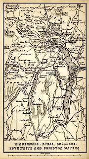 click to enlarge click to enlargeWLD3M1.jpg printed at bottom:- "WINDERMERE, RYDAL, GRASMERE, / ESTHWAITE AND CONISTON WATERS." item:- Armitt Library : A1201.64 Image © see bottom of page |
|||||||||||||||||||||||||
|
|
||||||||||||||||||||||||||
| evidence:- | old map:- Garnett 1850s-60s H placename:- Rydal Water |
|||||||||||||||||||||||||
| source data:- | Map of the English Lakes, in Cumberland, Westmorland and
Lancashire, scale about 3.5 miles to 1 inch, published by John
Garnett, Windermere, Westmorland, 1850s-60s.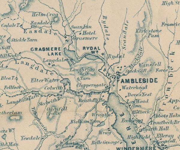 GAR2NY30.jpg "RYDAL WR." outline with shore form lines, lake or tarn item:- JandMN : 82.1 Image © see bottom of page |
|||||||||||||||||||||||||
|
|
||||||||||||||||||||||||||
| evidence:- | old print:- Pyne 1853 placename:- Rydal Water ??? |
|||||||||||||||||||||||||
| source data:- | Print, tinted lithograph, Rydal Water, Westmorland, by James Baker Pyne, engraved
by W Gauci, published by Thomas Agnew and Sons, Manchester, Lancashire, 1853.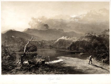 click to enlarge click to enlargePYN203.jpg "PAINTED BY J. B. PYNE. / W. GAUCI LITH. / MANCHESTER, PUBLISHED BY THOMAS AGNEW & SONS, 1853. / Rydal Water / M & N HANHART IMPT." item:- Armitt Library : A6678.4 Image © see bottom of page |
|||||||||||||||||||||||||
|
|
||||||||||||||||||||||||||
| evidence:- | old print:- Martineau 1855 |
|||||||||||||||||||||||||
| source data:- | Print, engraving, Rydal Water, drawn and engraved by W Banks, Edinburgh, published
by John Garnett, Windermere, Westmorland, and by Whittaker and Co, London, 1855.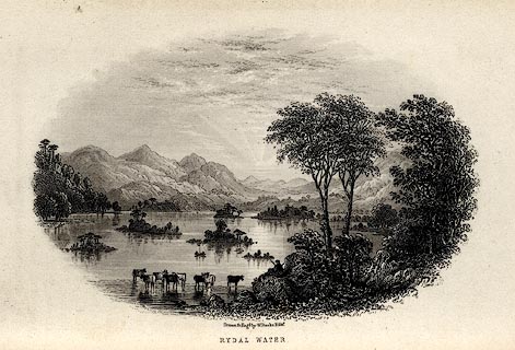 click to enlarge click to enlargeMNU108.jpg Opposite p.53 in A Complete Guide to the English Lakes, by Harriet Martineau. "Drawn &Eng'd by W Banks Sc Edinr. / RYDAL WATER." item:- Armitt Library : A1159.8 Image © see bottom of page |
|||||||||||||||||||||||||
|
|
||||||||||||||||||||||||||
| evidence:- | outline view:- Martineau 1855 |
|||||||||||||||||||||||||
| source data:- | Print, engraving, outline view, Mountains seen a little beyond Rydal Mount, drawn
by L Aspland, engraved by W Banks, Edinburgh, published by John Garnett, Windermere,
Westmorland, and by Whittaker and Co, London, 1855.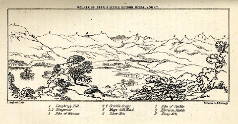 click to enlarge click to enlargeMNU109.jpg Opposite p.64 in A Complete Guide to the English Lakes, by Harriet Martineau. "MOUNTAINS SEEN A LITTLE BEYOND RYDAL MOUNT." "L Aspland Delt. / W Banks Sc Edinr." The view is captioned, numbers referring to mountains in the image:- "1 Loughrigg Fell, 2 Lingmoor, 3 Pike of Bliscow, 4 Crinkle Crags, 5 Meg's Gill Head, 6 Silver How, 7 Pike of Stickle, 8 Harrison Stickle, 9 Pavey Ark" item:- Armitt Library : A1159.9 Image © see bottom of page |
|||||||||||||||||||||||||
|
|
||||||||||||||||||||||||||
| evidence:- | old text:- Martineau 1855 item:- depth, Rydal Water |
|||||||||||||||||||||||||
| source data:- | Guide book, A Complete Guide to the English Lakes, by Harriet
Martineau, published by John Garnett, Windermere, Westmorland,
and by Whittaker and Co, London, 1855; published 1855-76. goto source Page 180:- "A TABLE OF THE LENGTH, BREADTH, AND DEPTH OF THE LAKES." "No. : Names of Lakes. : Counties : Length in Miles. : Extreme breadth in Miles : Extreme depth in Feet : Height above the Sea" "5 : Rydal Water : Westmorland : 0½ : ⅓: 54 : 156" |
|||||||||||||||||||||||||
|
|
||||||||||||||||||||||||||
| evidence:- | old print:- Nelson 1859 placename:- Rydal Mere |
|||||||||||||||||||||||||
| source data:- | Print, Nelson print, Rydal Mere taken near Wordsworth's House, Rydal, Westmorland,
published by T Nelson and Sons, London etc, 1859.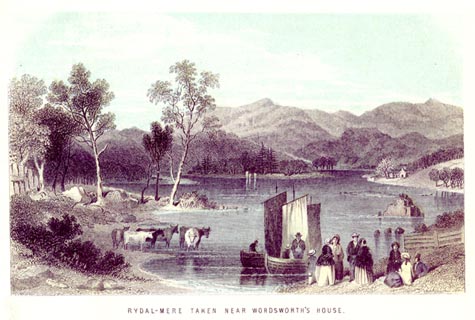 click to enlarge click to enlargeNS0509.jpg printed, bottom "RYDAL-MERE TAKEN NEAR WORDSWORTH'S HOUSE." item:- Armitt Library : 2003.13.9 Image © see bottom of page |
|||||||||||||||||||||||||
|
|
||||||||||||||||||||||||||
| evidence:- | old photograph:- Payn 1867 placename:- Rydal Water |
|||||||||||||||||||||||||
| source data:- | Photograph, sepia, Rydal Water and Nab Scar, Rydal, Westmorland, by Garnett and Sproat,
published by J Garnett, Windermere, Westmorland, 1867. click to enlarge click to enlargePN0301.jpg Frontispiece to The Lakes in Sunshine, text by James Payn. printed at bottom:- "RYDAL WATER AND NAB SCAR" item:- Fell and Rock Climbing Club : 184.1 Image © see bottom of page |
|||||||||||||||||||||||||
|
|
||||||||||||||||||||||||||
| evidence:- | old photograph:- Payn 1867 placename:- Rydal Water |
|||||||||||||||||||||||||
| source data:- | Photograph, sepia, Rydal Water, from Loughrigg Terrace, Westmorland, by Garnett and
Sproat, published by J Garnett, Windermere, Westmorland, 1867. click to enlarge click to enlargePN0317.jpg Tipped in opposite p.33 of The Lakes in Sunshine, text by James Payn. printed at bottom:- "RYDAL WATER, FROM LOUGHRIGG TERRACE." item:- Fell and Rock Climbing Club : 184.17 Image © see bottom of page |
|||||||||||||||||||||||||
|
|
||||||||||||||||||||||||||
| evidence:- | old map:- Jenkinson 1875 map1 placename:- |
|||||||||||||||||||||||||
| source data:- | Map, Windermere Section, Westmorland and Lancashire, ?colour
lithograph, scale about 1 mile to 1 inch, by Stanford's
Geographical Establishment, published by Edward Stanford, 55
Charing Cross, London, 1875.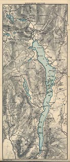 click to enlarge click to enlargeJK04.jpg item:- JandMN : 28.3 Image © see bottom of page |
|||||||||||||||||||||||||
|
|
||||||||||||||||||||||||||
| evidence:- | old print:- Walton 1876 placename:- Rydal Mere |
|||||||||||||||||||||||||
| source data:- | Print, colour lithograph, Rydal Mere, Westmorland, from a painting by Elijah Walton,
published by W M Thompson, 20 Cockspur Street, Pall Mall, and Burlington Gallery,
Piccadilly, London, 1876. click to enlarge click to enlargeWLT315.jpg Plate 15 in English Lake Scenery, with a description by T G Bonney. item:- JandMN : 469.15 Image © see bottom of page |
|||||||||||||||||||||||||
|
|
||||||||||||||||||||||||||
| evidence:- | old photograph:- Bell 1880s-1940s |
|||||||||||||||||||||||||
| source data:- | Photograph, black and white, stereo photo, Rydal Water and Loughrigg, Rydal, Westmorland,
by Herbert Bell, photographer, Ambleside, Westmorland, 1900s? click to enlarge click to enlargeHB0977.jpg ms at mount:- "Rydal Water &Loughrigg" printed at rev of mount:- "Herbert Bell / Ambleside." item:- Armitt Library : 2005.155 Image © see bottom of page |
|||||||||||||||||||||||||
|
|
||||||||||||||||||||||||||
| evidence:- | old photograph:- Bell 1880s-1940s |
|||||||||||||||||||||||||
| source data:- | Photograph, black and white, stereo photo, Rydal Lake and Silver How, Rydal, Westmorland,
by Herbert Bell, photographer, Ambleside, Westmorland, 1900s? click to enlarge click to enlargeHB0974.jpg ms at mount:- "Rydal Lake and Silver How" printed at rev of mount:- "Herbert Bell / Ambleside." item:- Armitt Library : 2005.154 Image © see bottom of page |
|||||||||||||||||||||||||
|
|
||||||||||||||||||||||||||
| evidence:- | old photograph:- Bell 1880s-1940s |
|||||||||||||||||||||||||
| source data:- | Photograph, black and white, stereo photo, Rydal Water, Rydal, Westmorland, by Herbert
Bell, photographer, Ambleside, Westmorland, 1900s? click to enlarge click to enlargeHB0967.jpg printed at rev of mount:- "Herbert Bell / Ambleside." item:- Armitt Library : 2005.147 Image © see bottom of page |
|||||||||||||||||||||||||
|
|
||||||||||||||||||||||||||
| evidence:- | old photograph:- Bell 1880s-1940s item:- boat house |
|||||||||||||||||||||||||
| source data:- | Photograph, sepia285x189, Rydal Water, Rydal, Wesymorland, by Herbert Bell, photographer,
Ambleside, Westmorland, 1890s.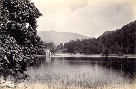 click to enlarge click to enlargeHB0893.jpg item:- Armitt Library : ALPS564 Image © see bottom of page |
|||||||||||||||||||||||||
|
|
||||||||||||||||||||||||||
| evidence:- | old photograph:- Bell 1880s-1940s item:- ice skating |
|||||||||||||||||||||||||
| source data:- | Photograph, sepia, ice skating on Rydal Water, Rydal, Westmorland, by Herbert Bell,
photographer, Ambleside, Westmorland, 1890s.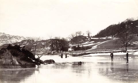 click to enlarge click to enlargeHB0681.jpg item:- Armitt Library : ALPS344 Image © see bottom of page |
|||||||||||||||||||||||||
|
|
||||||||||||||||||||||||||
| evidence:- | old photograph:- Bell 1880s-1940s item:- ice skating |
|||||||||||||||||||||||||
| source data:- | Photograph, sepia, ice skating on Rydal Water, Rydal, Westmorland, by Herbert Bell,
photographer, Ambleside, Westmorland, 1890s.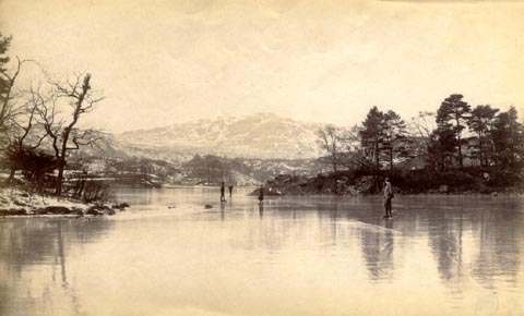 click to enlarge click to enlargeHB0680.jpg item:- Armitt Library : ALPS343 Image © see bottom of page |
|||||||||||||||||||||||||
|
|
||||||||||||||||||||||||||
| evidence:- | old photograph:- Bell 1880s-1940s |
|||||||||||||||||||||||||
| source data:- | Photograph, sepia, Rydal Water, winter, Rydal, Westmorland, by Herbert Bell, photographer,
Ambleside, Westmorland, 1890s.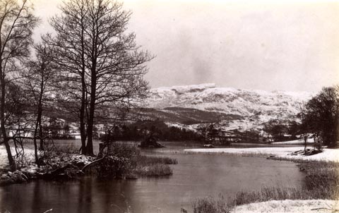 click to enlarge click to enlargeHB0679.jpg item:- Armitt Library : ALPS342 Image © see bottom of page |
|||||||||||||||||||||||||
|
|
||||||||||||||||||||||||||
| evidence:- | old photograph:- Bell 1880s-1940s |
|||||||||||||||||||||||||
| source data:- | Photograph, black and white, Rydal Water, the islands, Rydal, Westmorland, by Herbert
Bell, photographer, Ambleside, Westmorland, 1890s.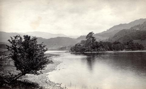 click to enlarge click to enlargeHB0677.jpg internegative at lower left:- "H. Bell" stamped on reverse:- "HERBERT BELL / Photographer / AMBLESIDE" item:- Armitt Library : ALPS341 Image © see bottom of page |
|||||||||||||||||||||||||
|
|
||||||||||||||||||||||||||
| evidence:- | old photograph:- Bell 1880s-1940s |
|||||||||||||||||||||||||
| source data:- | Photograph, black and white, Rydal Water, evening, Rydal, Westmorland, by Herbert
Bell, photographer, Ambleside, Westmorland, 1890s. click to enlarge click to enlargeHB0676.jpg stamped on reverse:- "HERBERT BELL / Photographer / AMBLESIDE" item:- Armitt Library : ALPS340 Image © see bottom of page |
|||||||||||||||||||||||||
|
|
||||||||||||||||||||||||||
| evidence:- | old photograph:- Bell 1880s-1940s |
|||||||||||||||||||||||||
| source data:- | Photograph, black and white, Rydal Water from White Moss, Rydal, Westmorland, by Herbert
Bell, photographer, Ambleside, Westmorland, 1890s. click to enlarge click to enlargeHB0675.jpg internegative at lower right:- "H. Bell" stamped on reverse:- "HERBERT BELL / Photographer / AMBLESIDE" item:- Armitt Library : ALPS339 Image © see bottom of page |
|||||||||||||||||||||||||
|
|
||||||||||||||||||||||||||
| evidence:- | old photograph:- Bell 1880s-1940s |
|||||||||||||||||||||||||
| source data:- | Photograph, sepia, Rydal Water from the west, Rydal, Westmorland, by Herbert Bell,
photographer, Ambleside, Westmorland, 1890s.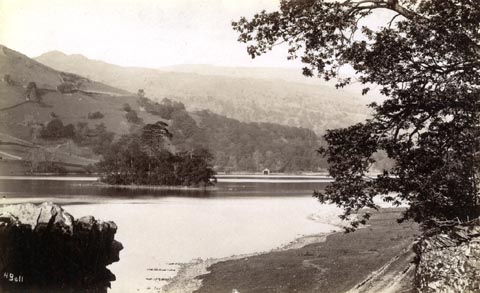 click to enlarge click to enlargeHB0673.jpg internegative at lower left:- "H. Bell" item:- Armitt Library : ALPS338 Image © see bottom of page |
|||||||||||||||||||||||||
|
|
||||||||||||||||||||||||||
| evidence:- | old photograph:- Bell 1880s-1940s |
|||||||||||||||||||||||||
| source data:- | Photograph, black and white, Rydal Water from the foot, Rydal, Westmorland, by Herbert
Bell, photographer, Ambleside, Westmorland, 1890s.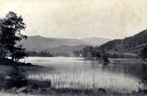 click to enlarge click to enlargeHB0674.jpg stamped on reverse:- "HERBERT BELL / Photographer / AMBLESIDE" item:- Armitt Library : ALPS337 Image © see bottom of page |
|||||||||||||||||||||||||
|
|
||||||||||||||||||||||||||
| evidence:- | old photograph:- Bell 1880s-1940s |
|||||||||||||||||||||||||
| source data:- | Photograph, sepia, Rydal Water from Stepsend, Rydal, Westmorland, by Herbert Bell,
photographer, Ambleside, Westmorland, 1890s.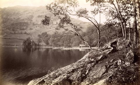 click to enlarge click to enlargeHB0672.jpg item:- Armitt Library : ALPS336 Image © see bottom of page |
|||||||||||||||||||||||||
|
|
||||||||||||||||||||||||||
| evidence:- | old photograph:- Bell 1880s-1940s |
|||||||||||||||||||||||||
| source data:- | Photograph, black and white, Rydal Water from Nab Scar, Rydal, Westmorland, by Herbert
Bell, photographer, Ambleside, Westmorland, 1890s. click to enlarge click to enlargeHB0671.jpg stamped on reverse:- "HERBERT BELL / Photographer / AMBLESIDE" item:- Armitt Library : ALPS335 Image © see bottom of page |
|||||||||||||||||||||||||
|
|
||||||||||||||||||||||||||
| evidence:- | old photograph:- Bell 1880s-1940s |
|||||||||||||||||||||||||
| source data:- | Photograph, black and white, Rydal Water, islands, Rydal, Westmorland, by Herbert
Bell, photographer, Ambleside, Westmorland, 1890s. click to enlarge click to enlargeHB0670.jpg stamped on reverse:- "HERBERT BELL / Photographer / AMBLESIDE" item:- Armitt Library : ALPS334 Image © see bottom of page |
|||||||||||||||||||||||||
|
|
||||||||||||||||||||||||||
| evidence:- | old photograph:- Bell 1880s-1940s |
|||||||||||||||||||||||||
| source data:- | Photograph, black and white, Rydal Water, Rydal, Westmorland, by Herbert Bell, photographer,
Ambleside, Westmorland, 1890s.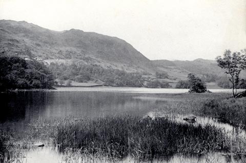 click to enlarge click to enlargeHB0669.jpg stamped on reverse:- "HERBERT BELL / Photographer / AMBLESIDE" item:- Armitt Library : ALPS332 Image © see bottom of page |
|||||||||||||||||||||||||
|
|
||||||||||||||||||||||||||
| evidence:- | old photograph:- Bell 1880s-1940s |
|||||||||||||||||||||||||
| source data:- | Photograph, sepia, Rydal Water and Nab Scar, Rydal, Westmorland, by Herbert Bell,
photographer, Ambleside, Westmorland, 1890s.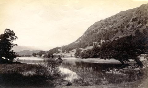 click to enlarge click to enlargeHB0668.jpg internegative at lower right:- "H. Bell" item:- Armitt Library : ALPS331 Image © see bottom of page |
|||||||||||||||||||||||||
|
|
||||||||||||||||||||||||||
| evidence:- | old photograph:- Bell 1880s-1940s |
|||||||||||||||||||||||||
| source data:- | Photograph, sepia, Rydal Water and Loughrigg Fell, Rydal, Westmorland, by Herbert
Bell, photographer, Ambleside, Westmorland, 1890s.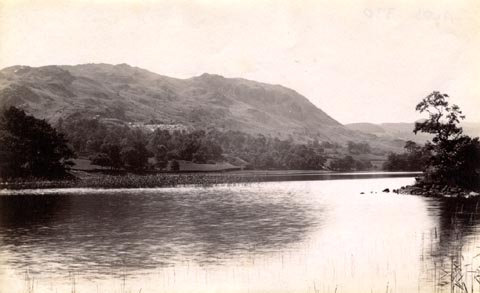 click to enlarge click to enlargeHB0667.jpg item:- Armitt Library : ALPS330 Image © see bottom of page |
|||||||||||||||||||||||||
|
|
||||||||||||||||||||||||||
| evidence:- | old photograph:- Bell 1880s-1940s |
|||||||||||||||||||||||||
| source data:- | Photograph, b/w, Rydal Water, Rydal, Westmorland, by Herbert Bell, Ambleside, Westmorland,
1890s? click to enlarge click to enlargeHB0267.jpg item:- Armitt Library : ALPS621 Image © see bottom of page |
|||||||||||||||||||||||||
|
|
||||||||||||||||||||||||||
| evidence:- | old print:- Bemrose 1881 placename:- Rydal Water |
|||||||||||||||||||||||||
| source data:- | Rydal Water on cover of guide book, Handy Guide to the English Lakes and Shap Spa
published about 1881.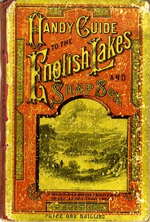 click to enlarge click to enlargeBEM1C.jpg Published by Bemrose and Sons, 23 Old Bailey, London and Derby, by A B Moss, Carlisle, Cumberland, and by T Wilson, Kendal, Westmorland, about 1881. item:- JandMN : 455 Image © see bottom of page |
|||||||||||||||||||||||||
|
|
||||||||||||||||||||||||||
| evidence:- | old map:- Pearson 1900s map (Win/Ryd/Gra) placename:- Rydal Water |
|||||||||||||||||||||||||
| source data:- | Map, lithograph, From Windermere to Rydal Water and Grasmere,
Westmorland, published by C Arthur Pearson, Henrietta Street,
London, 1900s.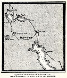 click to enlarge click to enlargePSN1M2.jpg On p.xxviii of Pearson's Gossipy Guide to the English Lakes and Neighbouring Districts. printed at bottom:- "By permission of the Controller of H.M. Stationery Office. / FROM WINDERMERE TO RYDAL WATER AND GRASMERE." item:- Armitt Library : A1188.4 Image © see bottom of page |
|||||||||||||||||||||||||
|
|
||||||||||||||||||||||||||
| evidence:- | old print:- Heaton Cooper 1905 (edn 1908) placename:- Rydal Water item:- sunset |
|||||||||||||||||||||||||
| source data:- | Print, colour halftone, Sunset, Rydal Water, Rydal, Westmorland, from a watercolour
painting by Alfred Heaton Cooper, published by Adam and Charles Black, London, 2nd
edn 1908.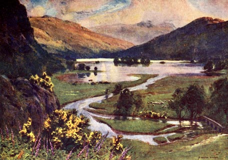 click to enlarge click to enlargeHC0114.jpg Opposite p.42 of The English Lakes, painted by Alfred Heaton Cooper, described by William T Palmer. printed at tissue opposite the print:- "SUNSET, RYDAL WATER" printed at signed lower right:- "[A HEATON COOPER]" item:- JandMN : 468.14 Image © see bottom of page |
|||||||||||||||||||||||||
|
|
||||||||||||||||||||||||||
| evidence:- | text:- Mason 1907 (edn 1930) |
|||||||||||||||||||||||||
| source data:- | Text book, The Ambleside Geography Books bk.III, The Counties of
England, by Charlotte M Mason, published by Kegan Paul, Trench,
Trubner and Co, Broadway House, 68-74 Carter Lane, and the
Parents' Educational Union Office, 26 Victoria Street, London,
edn 1930. MSN1P017.txt Page 17:- "..." "... we reach Rydal Water,- a fairy mere, with little, green, tree-shaded islands dotted over it, and with mountain shadows, and cloud shadows, and gleaming lights upon its waters. That rock, looking over the little lake, is "Wordsworth"s Seat," and on the slope of the fell is Rydal Mount, which was the home of this "Lake Poet."" |
|||||||||||||||||||||||||
|
|
||||||||||||||||||||||||||
| evidence:- | old map:- Postlethwaite 1877 (3rd edn 1913) placename:- Rydal Water |
|||||||||||||||||||||||||
| source data:- | Map, uncoloured engraving, Map of the Lake District Mining Field, Westmorland, Cumberland,
Lancashire, scale about 5 miles to 1 inch, by John Postlethwaite, published by W H
Moss and Sons, 13 Lowther Street, Whitehaven, Cumberland, 1877 edn 1913. PST2NY30.jpg "RYDAL WATER" lake item:- JandMN : 162.2 Image © see bottom of page |
|||||||||||||||||||||||||
|
|
||||||||||||||||||||||||||
| evidence:- | old text:- Burrow 1920s placename:- |
|||||||||||||||||||||||||
| source data:- | Road book, strip maps with parts in Westmorland, Cumberland etc,
irregular scales about 1.5 miles to 1 inch, by E J Burrow and
Co, Cheltenham, Gloucestershire, 1920s. "... It is but two miles from here [Ambleside] to Rydal, ... The road passes close beside the tiny but very charming lake of Rydal Water, ..." |
|||||||||||||||||||||||||
|
|
||||||||||||||||||||||||||
| evidence:- | old map:- Burrow 1920s |
|||||||||||||||||||||||||
| source data:- | Road book, On the Road, Dunlop Pictorial Road Plans, volume V,
strip maps with parts in Westmorland, Cumberland etc, irregular
scale about 1.5 miles to 1 inch, by E J Burrow and Co,
Cheltenham, Gloucestershire, 1920s. EJB3Vg38.jpg item:- private collection : 17 Image © see bottom of page |
|||||||||||||||||||||||||
|
|
||||||||||||||||||||||||||
| evidence:- | old photograph:- Photochrom 1930s placename:- Rydal Water |
|||||||||||||||||||||||||
| source data:- | Photograph, black and white halftone print, Rydal Water and Nab Scar, Westmorland,
published by Photochrom Co, Tunbridge Wells, Kent, 1930s? click to enlarge click to enlargePCH108.jpg printed, "Rydal Water and Nab / Scar. / ..." item:- JandMN : 1015.8 Image © see bottom of page |
|||||||||||||||||||||||||
|
|
||||||||||||||||||||||||||
| evidence:- | old print:- Pearson 1900s placename:- Rydal Mere |
|||||||||||||||||||||||||
| source data:- | Print, halftone photograph, Rydal Mere, from the West, Westmorland, published by C
Arthur Pearson, Henrietta Street, London, 1900s.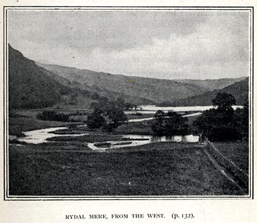 click to enlarge click to enlargePS1E43.jpg On p.117 of Pearson's Gossipy Guide to the English Lakes and Neighbouring Districts. printed at bottom:- "RYDAL MERE, FROM THE WEST. (p.132)." item:- Armitt Library : A1188.50 Image © see bottom of page |
|||||||||||||||||||||||||
|
|
||||||||||||||||||||||||||
| evidence:- | old print:- Rowbotham 1875 |
|||||||||||||||||||||||||
| source data:- | Print, chromograph, Rydal Water, Westmorland, by T L Rowbotham, published by Marcus
Ward and Co, 67-68 Chandos Street, Covent Garden, London, and Belfast, 1875.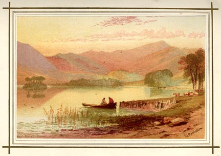 click to enlarge click to enlargeLF1E05.jpg Tipped in opposite p.42 of English Lake Scenery, by W J Loftie. printed at lower right:- "T L Rowbotham" printed at lower left:- "MARCUS WARD &CO. CHROMO" item:- Armitt Library : A963.5 Image © see bottom of page |
|||||||||||||||||||||||||
|
|
||||||||||||||||||||||||||
| evidence:- | old print:- Matthew 1866 placename:- Rydal Water |
|||||||||||||||||||||||||
| source data:- | Print, engraving, Rydal Water, from the High Road Leading to the Wishing Gate, Westmorland,
drawn by R Howe, engraved by J Saddler, published by J Richardson, Highgate, Kendal,
Westmorland, 1866.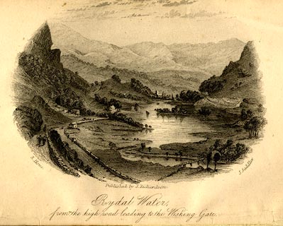 click to enlarge click to enlargeMW1E01.jpg Frontispiece to The English Lakes, Peaks and Passes, from Kendal to Keswick, by George King Matthew. printed at lower left, right, centre:- "R. Howe. / J, Saddler. / Published by J. Richardson. / Rydal Water, / from the high road leading to the Wishing Gate" item:- Armitt Library : A1168.1 Image © see bottom of page |
|||||||||||||||||||||||||
|
|
||||||||||||||||||||||||||
| evidence:- | old print:- Payn 1860s-70s placename:- Rydal Water |
|||||||||||||||||||||||||
| source data:- | Print, colour printed, Heron Island, Rydal Water, Westmorland, published by John Garnett,
Windermere, Westmorland, and by Simpkin, Marshall and Co, London, 1860s-70s?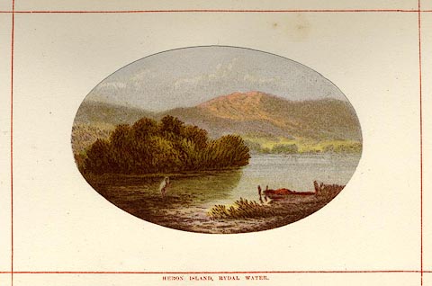 click to enlarge click to enlargePN0106.jpg Tipped in opposite p.24 of England's Lakeland, a Tour Therein, by James Payn. printed at bottom:- "HERON ISLAND, RYDAL WATER." item:- Armitt Library : A1183.6 Image © see bottom of page |
|||||||||||||||||||||||||
|
|
||||||||||||||||||||||||||
| evidence:- | old print:- Sylvan 1847 placename:- Rydal Water item:- fishing |
|||||||||||||||||||||||||
| source data:- | Print, engraving, Rydal Water, Westmorland, published by John Johnstone, Paternoster
Row, London, et al, 1847.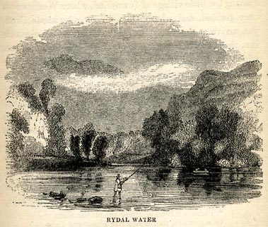 click to enlarge click to enlargeSYL116.jpg On p.51 of Sylvan's Pictorial Guide to the English Lakes. printed at bottom:- "RYDAL WATER." item:- Armitt Library : A1201.16 Image © see bottom of page |
|||||||||||||||||||||||||
|
|
||||||||||||||||||||||||||
| evidence:- | old print:- Tattersall 1836 (version 1869) placename:- Rydal Water |
|||||||||||||||||||||||||
| source data:- | Print, hand coloured, Rydal Water, from the South East, Westmorland, drawn by George
Tattersall, 1836, engraved by W F Topham, published by T J Allman, 463 Oxford Street,
London, 1869.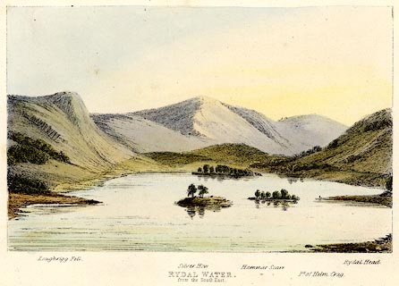 click to enlarge click to enlargeTAT206.jpg Included in The Lakes of England, by W F Topham. printed at bottom:- "RYDAL WATER, / from the South East." printed at bottom:- "Loughrigg Fell. / Silver How. / Hammar Scarr. / Pt. of Helm Crag. / Rydal Head." item:- Armitt Library : A1067.6 Image © see bottom of page |
|||||||||||||||||||||||||
|
|
||||||||||||||||||||||||||
| evidence:- | outline view:- Tattersall 1836 placename:- Rydal Water |
|||||||||||||||||||||||||
| source data:- | Print, engraving, Rydal Water, from the South East, Westmorland, drawn by George Tattersall,
engraved by W F Topham, published by Sherwood and Co, Paternoster Row, London, about
1836.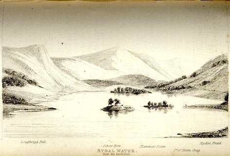 click to enlarge click to enlargeTAT111.jpg The print is captioned with mountain names and acts as an outline view. Tipped in opposite p.44 of The Lakes of England, by George Tattersall. printed at bottom:- "RYDAL WATER, / from the South East." printed at bottom left to right:- "Loughrigg Fell. / Silver How. / Hammar Scarr. / Pt. of Helm Crag. / Rydal Head." item:- Armitt Library : A1204.12 Image © see bottom of page |
|||||||||||||||||||||||||
|
|
||||||||||||||||||||||||||
| evidence:- | old print:- Green 1819 placename:- Rydal Water |
|||||||||||||||||||||||||
| source data:- | Print, aquatint, Rydal Water, Westmorland, by William Green, 1819, published by R
Lough and Co, Chronicle Office, Finkle Street, Kendal, and others, 1820.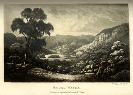 click to enlarge click to enlargeGN0114.jpg Tipped in opposite vol.1 p.388 of The Tourist's New Guide, by William Green. printed at bottom right, centre:- "Vol.I, page 388, line 3. / SHAP ABBEY. / Published at Ambleside, Augt. 1. 1819, by Wm. Green." item:- Armitt Library : A1141.15 Image © see bottom of page |
|||||||||||||||||||||||||
|
|
||||||||||||||||||||||||||
| evidence:- | old print:- Robertson 1911 placename:- Rydal Water |
|||||||||||||||||||||||||
| source data:- | Print, lithograph? Rydal Water, from a watercolour by Arthur Tucker, published by
Chatto and Windus, London, 1911.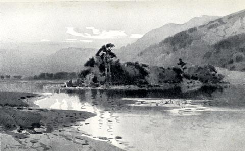 click to enlarge click to enlargeRSN140.jpg Tipped in opposite p.266 of Wordsworthshire by Eric Robertson. Heron Island in the middle ground? printed at bottom:- "RYDAL WATER" signed at painting lower left:- "Arthur Tucker" item:- JandMN : 197.44 Image © see bottom of page |
|||||||||||||||||||||||||
|
|
||||||||||||||||||||||||||
| evidence:- | old print:- Philip/Wilson 1890s |
|||||||||||||||||||||||||
| source data:- | Print, engraving, Skating on Rydal Water, published by George Philip and Son, London,
Philip, Son and Nephew, Liverpool, Lancashire, and Titus Wilson, Kendal, Westmorland,
about 1895.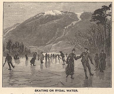 click to enlarge click to enlargePW1E22.jpg "SKATING ON RYDAL WATER." item:- JandMN : 58.23 Image © see bottom of page |
|||||||||||||||||||||||||
|
|
||||||||||||||||||||||||||
| evidence:- | old print:- placename:- Rydal Water |
|||||||||||||||||||||||||
| source data:- | Print, coloured wood engraving? Rydal Water, from Loughrigg Terrace, Westmorland,
published or sold by John Walker and Co, 85 Farringdon Street, London, 1880s-90s?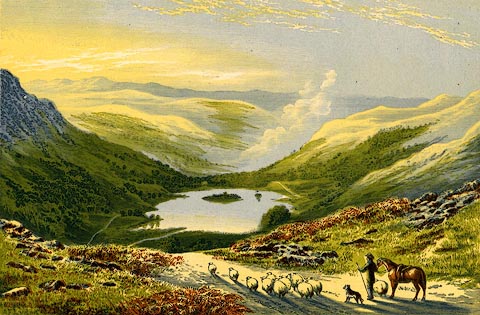 click to enlarge click to enlargePR0532.jpg A small flock of sheep being driven in the foreground. printed at bottom:- "RYDAL WATER, FROM LOUGHRIGG TERRACE." stamped at bottom left:- "JOHN WALKER &CO. / LONDON. / 85 FARRINGDON ST." item:- Dove Cottage : 2008.107.481 Image © see bottom of page |
|||||||||||||||||||||||||
|
|
||||||||||||||||||||||||||
| evidence:- | old print:- placename:- Rydal Mere |
|||||||||||||||||||||||||
| source data:- | Print, engraving with lithograph colour? Rydal Mere taken near Wordsworth's House,
Westmorland, 1860s-70s?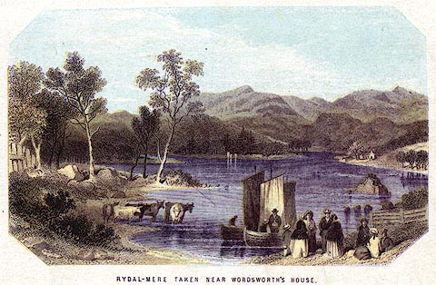 click to enlarge click to enlargePR0380.jpg A party going sailing in the foreground. printed at bottom:- "RYDAL-MERE TAKEN NEAR WORDSWORTH'S HOUSE." item:- Dove Cottage : 2008.107.380 Image © see bottom of page |
|||||||||||||||||||||||||
|
|
||||||||||||||||||||||||||
| evidence:- | old print:- Nelson 1859 placename:- Rydal Mere |
|||||||||||||||||||||||||
| source data:- | Print, engraving, Rydal Mere taken near Wordsworth's House, drawn by Keeley Halswelle,
Edinburgh, published by T Nelson and Sons, Paternoster Row, London, and Edinburgh
and New York, United States, 1859.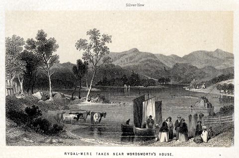 click to enlarge click to enlargeNS0108.jpg Tipped in oppposite p.238 of a guide book, The English Lakes. printed at bottom:- "RYDAL-MERE TAKEN NEAR WORDSWORTH'S HOUSE." item:- JandMN : 336.8 Image © see bottom of page |
|||||||||||||||||||||||||
|
|
||||||||||||||||||||||||||
| evidence:- | old print:- Pyne 1853 placename:- Rydal Water |
|||||||||||||||||||||||||
| source data:- | Rydal Water drawn by James Barker Pyne, 1848-1853, lithographed by T Picken, 1859. click to enlarge click to enlargePY07.jpg "Rydal Water" item:- JandMN : 97.8 Image © see bottom of page |
|||||||||||||||||||||||||
|
|
||||||||||||||||||||||||||
| evidence:- | old print:- Garnett 1850s-60s F placename:- Rydal Water |
|||||||||||||||||||||||||
| source data:- | Print, uncoloured engraving, Rydal Water, Westmorland, engraved by William Banks,
Edinburgh, probably published by John Garnett, Windermere, Westmorland, 1850s-60s? click to enlarge click to enlargeGAR728.jpg Found with Views of the English Lakes. printed at bottom:- "Drawn &Engd. by W. Banks Edinr. / RYDAL WATER." item:- JandMN : 165.28 Image © see bottom of page |
|||||||||||||||||||||||||
|
|
||||||||||||||||||||||||||
| evidence:- | old print:- Garnett 1850s-60s F |
|||||||||||||||||||||||||
| source data:- | Print, uncoloured engraving, Rydal Water, Westmorland, drawn and engraved by William
Banks, Edinburgh, published by John Garnett, Windermere, Westmorland, 1850s-60s? click to enlarge click to enlargeGAR721.jpg Found with Views of the English Lakes. There are rather a lot of islands? printed at bottom:- "Drawn &Engd. by W. Banks, Edinr." item:- JandMN : 165.21 Image © see bottom of page |
|||||||||||||||||||||||||
|
|
||||||||||||||||||||||||||
| evidence:- | old print:- placename:- Rydal Lake |
|||||||||||||||||||||||||
| source data:- | Print, uncoloured engraving, Rydal Lake, Rydal, Westmorland, by ?B Foster, engraved
by E Evans, 1850s-60s? click to enlarge click to enlargePR0490.jpg printed at bottom left, right, centre:- "[B] Foster / E. EVANS SC. / RYDAL LAKE" item:- Dove Cottage : 2008.107.439 Image © see bottom of page |
|||||||||||||||||||||||||
|
|
||||||||||||||||||||||||||
| evidence:- | old print:- Harwood 1842 |
|||||||||||||||||||||||||
| source data:- | Print, uncoloured engraving, A Glimpse through the Trees, Rydal Water, drawn by W
P George, engraved and published by John Harwood, 26 Fenchurch Street, London, 1850s.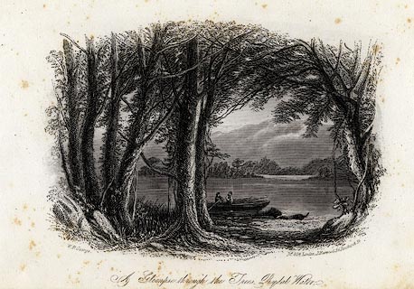 click to enlarge click to enlargeHRW205.jpg printed at bottom left, right, centre:- "W. P. George. / No.804. London, J. Harwood, 26, Fenchurch Street. / A Glimpse through the Trees, Rydal Water, / near the residence of the late W. Wordsworth Esqr." item:- JandMN : 166.5 Image © see bottom of page |
|||||||||||||||||||||||||
|
|
||||||||||||||||||||||||||
| evidence:- | old print:- Harwood 1842 placename:- Rydal Lake |
|||||||||||||||||||||||||
| source data:- | Print, uncoloured engraving, Rydal Lake, Westmoreland, engraved and published by John
and Frederick Harwood, 26 Fenchurch Street, London, 1842.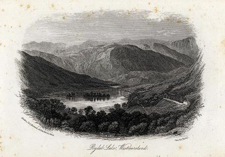 click to enlarge click to enlargeHRW204.jpg printed at bottom left, right, centre:- "London, J &F. Harwood, 26, Fenchurch Street. / Septr. 16th. 1842. / Rydal Lake, Westmoreland." item:- JandMN : 166.4 Image © see bottom of page |
|||||||||||||||||||||||||
|
|
||||||||||||||||||||||||||
| evidence:- | old print:- placename:- Rydal Water |
|||||||||||||||||||||||||
| source data:- | Print, uncoloured engraving, Rydal Water, Westmoreland, published by John William
Parker, West Strand, London, 1837.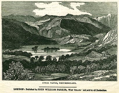 click to enlarge click to enlargePR0320.jpg On page 16 of the Saturday Magazine, 8 July 1837. The pages have text relevant to English Lake Scenery. printed at bottom:- "RYDAL WATER, WESTMORELAND." item:- Dove Cottage : 2008.107.320 Image © see bottom of page |
|||||||||||||||||||||||||
|
|
||||||||||||||||||||||||||
| evidence:- | old print:- Rose 1832-35 (vol.3 no.42) placename:- Rydal Water |
|||||||||||||||||||||||||
| source data:- | Print, uncoloured engraving, Rydal Water and Grassmere, from Rydal Park, Westmorland,
by George Pickering, engraved by W J Cooke, published by Fisher, Son and Co, London,
1835.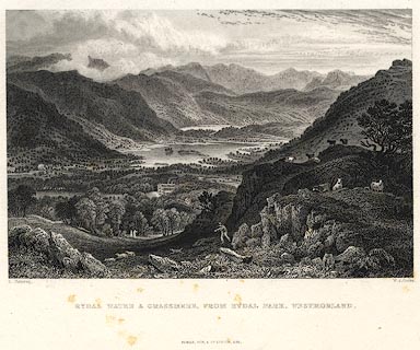 click to enlarge click to enlargePR0423.jpg Originally vol.3 no.42 in Westmorland, Cumberland, Durham and Northumberland Illustrated. printed at bottom left, right, centre:- "G. Pickering. / W. J. Cooke. / RYDAL WATER & GRASSMERE, FROM RYDAL PARK, WESTMORLAND. / FISHER, SON &Co. LONDON, 1835." item:- Dove Cottage : 2008.107.416 Image © see bottom of page |
|||||||||||||||||||||||||
|
|
||||||||||||||||||||||||||
| evidence:- | old print:- Rose 1832-35 |
|||||||||||||||||||||||||
| source data:- | Print, engraving, Rydal Water, near Ivy Cottage, Westmorland, by Thomas Allom, engraved
by R Sands, 1834.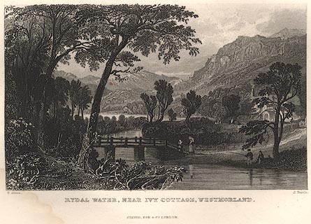 click to enlarge click to enlargeR230.jpg item:- JandMN : 66.38 Image © see bottom of page |
|||||||||||||||||||||||||
|
|
||||||||||||||||||||||||||
| evidence:- | old print:- placename:- Great Rydal Lake |
|||||||||||||||||||||||||
| source data:- | Print, uncoloured engraving, Great Rydal Lake, Westmorland, drawn by W Westall, engraved
by E Finden, published by Charles Tilt, 86 Fleet Street, London, 1830.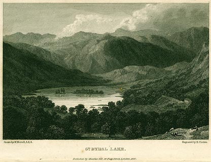 click to enlarge click to enlargePR0154.jpg printed at bottom left, right, centre:- "Drawn by W. Westall, A.R.A. / Engraved by E. Finden. / GT. RYDAL LAKE, / Published by Charles Tilt, 86, Fleet Street, London, 1830." item:- Dove Cottage : 2008.107.154 Image © see bottom of page |
|||||||||||||||||||||||||
|
|
||||||||||||||||||||||||||
| evidence:- | old print:- placename:- Rydal Water |
|||||||||||||||||||||||||
| source data:- | Print, hand coloured engraving, Rydal Water from the South, Westmorland, drawn by
J Bishop, engraved by J Gellatly, published by J Menzies, 61 Princes Street, Edinburgh,
1820s-30s?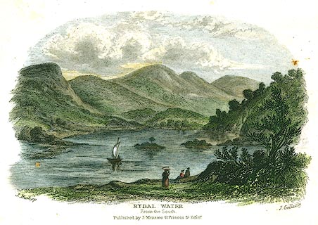 click to enlarge click to enlargePR0295.jpg printed at bottom left, right, centre:- "J. Bishop / J. Gellatly / RYDAL WATER / From the South. / Published by J. Menzies 61, Princes St. Edinr." item:- Dove Cottage : 2008.107.295 Image © see bottom of page |
|||||||||||||||||||||||||
|
|
||||||||||||||||||||||||||
| evidence:- | old print:- Green 1815 (plate 28) placename:- Rydal Water |
|||||||||||||||||||||||||
| source data:- | Print, colour aquatint, Rydal Water, by William Green, Ambleside, Westmorland, 1815. click to enlarge click to enlargePR0114.jpg Plate 28 in a set of prints, Lake Scenery. printed at bottom:- "RYDAL WATER. / Published at Ambleside, June 1, 1815, by Wm. Green." item:- Dove Cottage : 2008.107.114 Image © see bottom of page |
|||||||||||||||||||||||||
|
|
||||||||||||||||||||||||||
| evidence:- | old print:- Smith and Emes 1794-95 (plate 8) placename:- Rydal Water |
|||||||||||||||||||||||||
| source data:- | Print, aquatint, Rydal Water, Westmorland, drawn by John 'Warwick' Smith, engraved
by Samuel Alken, published by W Clarke, New Bond Street, London, 1794-95. click to enlarge click to enlargePR0433.jpg PLate 8 in Views of the Lakes. printed at bottom, left, right, centre:- "J. Smith delt. / S. Alken fecit / Rydal Water" item:- private collection : 97 Image © see bottom of page |
|||||||||||||||||||||||||
|
|
||||||||||||||||||||||||||
| evidence:- | old print with text:- Farington 1789 (plate 6) item:- house; cottage |
|||||||||||||||||||||||||
| source data:- | Print, engraving, Rydal Mere ie Rydal Water, Westmorland, painted by Joseph Farington,
engraved by B T Pouncy, published by W Byrne, 79 Titchfield Street, London, 1785.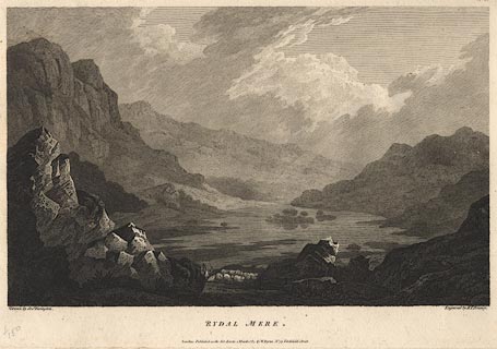 click to enlarge click to enlargeBMZ76.jpg Plate 6 from Views of the Lakes, &c, in Cumberland and Westmorland, published 1789; with descriptive text:- "RYDAL-MERE" "IS the least in Extent of any of the Lakes in this Set. It is about two Miles from Ambleside, and is formed by the Stream of Rothay, in its Course from Grasmere to Winandermere. The View given in this Plate has the Appearance of an Amphitheatre. The wild and desert Air of the Mountains, which rise immediately from its Margin, exhibits a striking Contrast to the Luxuriance and Cultivation of the Vale of Grasmere. This Variety of Character assumed by the several Lakes affords no small Source of Entertainment to the Admirer of picturesque Beauty. The Richness of the Cultivated Vale and the savage Aspect of the Rocks, with the infinite Variety of Combinations they admit of, present him with the beautiful and sublime through all their possible Gradations.He will remark too with Pleasure, that this Country, so far from having suffered by the Hand of Art, derives considerable Advantage from accidental Circumstances. That the white or Grey-Stone Cottages, with Ash-coloured Slating, are scattered over the Face of the Country, enlivening the Landscape, without affecting its Simplicity; and that even the dark Hue of the Fir-Tree, which is frequently planted near them, is beautifully contrasted with the Brilliancy of the Silver Rock. In passing the River, or Mountain Torrent, he will find the same Propriety preserved in the rude and varied Construction of their Bridges; as if the Genius of the Country, jealous of the officious Interference of Man, had directed the Taste of the Inhabitants." item:- Dove Cottage : Lowther.5 Image © see bottom of page |
|||||||||||||||||||||||||
|
|
||||||||||||||||||||||||||
| evidence:- | old print:- Gresham Publishing 1900s placename:- Rydalmere |
|||||||||||||||||||||||||
| source data:- | Print, colour halftone, Rydalmere, Rydal, Westmorland, by Ernest W Haslehurst, published
by The Gresham Publishing Co, 66 Chandos Street, London, 1900s?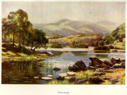 click to enlarge click to enlargePR1561.jpg Tipped in opposite p.12 of The English Lakes section of a volume of Our Beautiful Homeland. printed at bottom:- "RYDALMERE" printed at lower right:- "E. W. HASLEHURST" item:- JandMN : 381.3 Image © see bottom of page |
|||||||||||||||||||||||||
|
|
||||||||||||||||||||||||||
| evidence:- | old print:- Goodwin 1887 (edn 1890) placename:- Rydal Water |
|||||||||||||||||||||||||
| source data:- | Print, etching? Rydal Water, Rydal, Westmorland, by Harry Goodwin, published by Swan
Sonnenschein and Co, Paternoster Square, London, 1890. click to enlarge click to enlargePR1613.jpg Tipped in opposite p.214 of Through the Wordsworth Country, by William Knight. printed at lower centre:- "Rydal Water" item:- JandMN : 382.43 Image © see bottom of page |
|||||||||||||||||||||||||
|
|
||||||||||||||||||||||||||
| evidence:- | old drawing:- placename:- Rydale Lake |
|||||||||||||||||||||||||
| source data:- | Drawing, Rydale Lake, Rydal, Westmorland, by William James Blacklock, 1850s.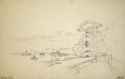 click to enlarge click to enlargePR1028.jpg To right of composition winds a track bounded on one side by a fence and woodland and on the other by a drystone wall to left of which lies sloping shore of lake. Several vegetation topped islets rise from water. Beyond far shore rise barren fells. inscribed at bottom left:- "Rydale Lake" item:- Tullie House Museum : 1970.28.2 Image © Tullie House Museum |
|||||||||||||||||||||||||
|
|
||||||||||||||||||||||||||
| evidence:- | old print:- Ritter 1849 placename:- Rydal Water |
|||||||||||||||||||||||||
| source data:- | Print, uncoloured engraving, Rydal Water, Rydal, Westmorland, published by the Religious
Tract Society, The Depository, 56 Paternoster Row, and 65 St Paul's Churchyard, London,
1849?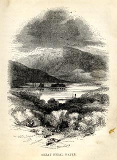 click to enlarge click to enlargeRT0102.jpg Tipped opposite p.38 of Loitering among the Lakes of Cumberland and Westmoreland, by Paul Ritter? printed at bottom:- "GREAT RYDAL WATER." printed at lower right:- "[ ]" item:- Fell and Rock Climbing Club : 2.3 Image © see bottom of page |
|||||||||||||||||||||||||
|
|
||||||||||||||||||||||||||
Lakes Guides menu.