 Old Cumbria Gazetteer
 |
 |
|
| Three Shire Stones, Wrynose | ||
| Three Shire Stones | ||
| Brandreth | ||
| Three Foot Brandreth | ||
| site name:- | Wrynose Pass | |
| civil parish:- | Ulpha (formerly Cumberland) | |
| civil parish:- | Dunnerdale-with-Seathwaite (formerly Lancashire) | |
| civil parish:- | Coniston (formerly Lancashire) | |
| civil parish:- | Lakes (formerly Westmorland) | |
| county:- | Cumbria | |
| locality type:- | boundary stone | |
| locality type:- | stone | |
| locality type:- | county boundary mark | |
| coordinates:- | NY27720274 | |
| 1Km square:- | NY2702 | |
| 10Km square:- | NY20 | |
|
|
||
 BLK31.jpg (taken 17.11.2005) 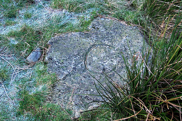 BLK30.jpg (taken 17.11.2005) 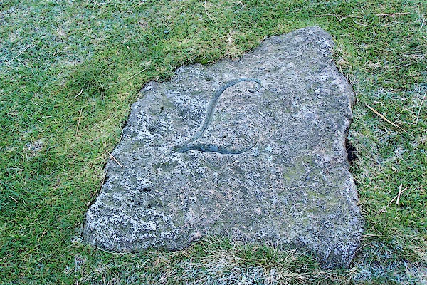 BLK29.jpg (taken 17.11.2005) |
||
|
|
||
| evidence:- | old map, old map:- OS County Series (Cmd 80) placename:- Threefoot Brandreth placename:- Three Shire Stone |
|
| source data:- | Maps, County Series maps of Great Britain, scales 6 and 25
inches to 1 mile, published by the Ordnance Survey, Southampton,
Hampshire, from about 1863 to 1948. "Threefoot Brandreth" |
|
| source data:- | Maps, County Series maps of Great Britain, scales 6 and 25
inches to 1 mile, published by the Ordnance Survey, Southampton,
Hampshire, from about 1863 to 1948. "Three Shire Stone or Threefoot Brandreth" |
|
|
|
||
| evidence:- | old map:- Saxton 1579 placename:- Shirestones upon Wrenose |
|
| source data:- | Map, hand coloured engraving, Westmorlandiae et Cumberlandiae Comitatus ie Westmorland
and Cumberland, scale about 5 miles to 1 inch, by Christopher Saxton, London, engraved
by Augustinus Ryther, 1576, published 1579-1645.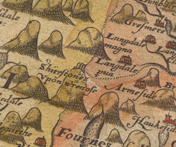 Sax9NY20.jpg "Shirestones Upon wrenose" 3+ stones drawn on a large hillock; county boundary of Cumberlandia, Westmorelandia and Lancastria. item:- private collection : 2 Image © see bottom of page |
|
|
|
||
| evidence:- | old map:- Mercator 1595 (edn?) placename:- |
|
| source data:- | Map, hand coloured engraving, Northumbria, Cumberlandia, et
Dunelmensis Episcopatus, ie Northumberland, Cumberland and
Durham etc, scale about 6.5 miles to 1 inch, by Gerard Mercator,
Duisberg, Germany, about 1595.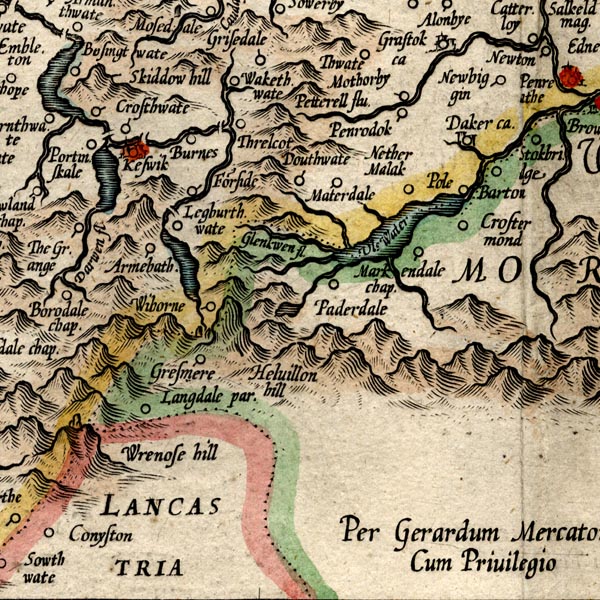 MER8CumF.jpg "" stones on Wrynose, on county boundary with Westmorland and Lancashire item:- JandMN : 169 Image © see bottom of page |
|
|
|
||
| evidence:- | old map:- Speed 1611 (Cmd) placename:- Shire Stones upon Wrenose |
|
| source data:- | Map, hand coloured engraving, Cumberland and the Ancient Citie
Carlile Described, scale about 4 miles to 1 inch, by John Speed,
1610, published by J Sudbury and George Humble, Popes Head
Alley, London, 1611-12. SP11NY20.jpg "Shire Stones upon Wrenose" two standing stones, on a hillock at the county boundaries item:- private collection : 16 Image © see bottom of page |
|
|
|
||
| evidence:- | old map:- Jansson 1646 placename:- Shire Stones upon Wrenose |
|
| source data:- | Map, hand coloured engraving, Cumbria and Westmoria, ie
Cumberland and Westmorland, scale about 3.5 miles to 1 inch, by
John Jansson, Amsterdam, Netherlands, 1646. JAN3NY20.jpg "Shire Stones Upon Wrenose" Two, only, square pillars are drawn, on the county boundaries. item:- JandMN : 88 Image © see bottom of page |
|
|
|
||
| evidence:- | old map:- Morden 1695 (Cmd) placename:- Shire Stones upon Wrenose |
|
| source data:- | Map, uncoloured engraving, Cumberland, scale about 4 miles to 1
inch, by Robert Morden, 1695, published by Abel Swale, the
Unicorn, St Paul's Churchyard, Awnsham, and John Churchill, the
Black Swan, Paternoster Row, London, 1695-1715. MD12NY20.jpg "Shire Stones Upon Wrenose" Two upright stones. item:- JandMN : 90 Image © see bottom of page |
|
|
|
||
| evidence:- | old map:- Badeslade 1742 placename:- Shire Stone upon Wrenose |
|
| source data:- | Map, uncoloured engraving, A Map of Cumberland North from
London, scale about 11 miles to 1 inch, with descriptive text,
by Thomas Badeslade, London, engraved and published by William
Henry Toms, Union Court, Holborn, London, 1742. click to enlarge click to enlargeBD10.jpg "Shire Stone upon Wrenose" one standing stone item:- JandMN : 115 Image © see bottom of page |
|
|
|
||
| evidence:- | descriptive text:- Simpson 1746 placename:- Shire Stones |
|
| source data:- | Atlas, three volumes of maps and descriptive text published as
'The Agreeable Historian, or the Compleat English Traveller
...', by Samuel Simpson, 1746. goto source goto source"..." "... the Mountain called Wry Nose, upon the Top of which, near the Highway-Side, are to be seen three Stones, commonly call'd Shire-Stones, lying within a Foot of one another, yet in three several Counties, viz. one in Cumberland, another in Westmorland, and the third in Lancashire. ..." |
|
|
|
||
| evidence:- | possibly old map:- Simpson 1746 map (Wmd) |
|
| source data:- | Map, uncoloured engraving, Westmorland, scale about 8 miles to 1
inch, printed by R Walker, Fleet Lane, London, 1746.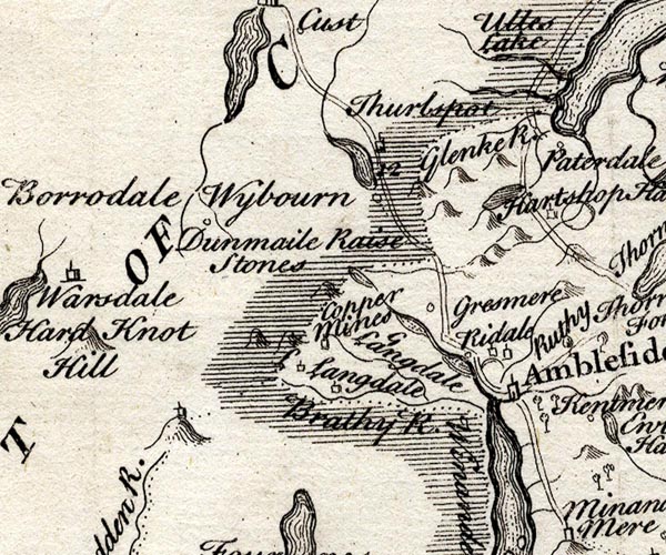 SMP2NYF.jpg Hillock; building on top; on border with Lancashire. item:- Dove Cottage : 2007.38.59 Image © see bottom of page |
|
|
|
||
| evidence:- | old map:- Bowen and Kitchin 1760 placename:- Three Shire Stones |
|
| source data:- | Map, hand coloured engraving, A New Map of the Counties of
Cumberland and Westmoreland Divided into their Respective Wards,
scale about 4 miles to 1 inch, by Emanuel Bowen and Thomas
Kitchin et al, published by T Bowles, Robert Sayer, and John
Bowles, London, 1760.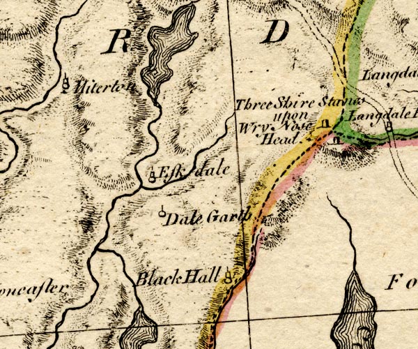 BO18SD19.jpg "Three Shire Stones upon Wry Nose Head" two stones standing at meet of county boundaries Westmorland Cumberland Lancashire item:- Armitt Library : 2008.14.10 Image © see bottom of page |
|
|
|
||
| evidence:- | old map:- Jefferys 1770 (Wmd) placename:- Three Shire Stones |
|
| source data:- | Map, 4 sheets, The County of Westmoreland, scale 1 inch to 1
mile, surveyed 1768, and engraved and published by Thomas
Jefferys, London, 1770.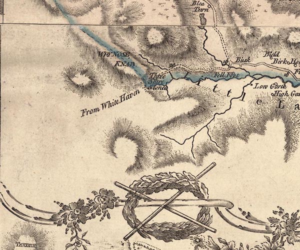 J5NY20SE.jpg "Three Shire Stones" one standing stone, on county boundary item:- National Library of Scotland : EME.s.47 Image © National Library of Scotland |
|
|
|
||
| evidence:- | old map:- Donald 1774 (Cmd) placename:- Three Shire Stones |
|
| source data:- | Map, hand coloured engraving, 3x2 sheets, The County of Cumberland, scale about 1
inch to 1 mile, by Thomas Donald, engraved and published by Joseph Hodskinson, 29
Arundel Street, Strand, London, 1774.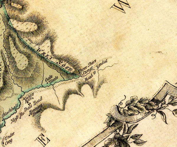 D4NY20SE.jpg "Three Shire Stones" no symbol, marking county boundary with Westmorland and Lancashire item:- Carlisle Library : Map 2 Image © Carlisle Library |
|
|
|
||
| evidence:- | old map:- West 1784 map placename:- Shire Stones |
|
| source data:- | Map, hand coloured engraving, A Map of the Lakes in Cumberland,
Westmorland and Lancashire, scale about 3.5 miles to 1 inch,
engraved by Paas, 53 Holborn, London, about 1784.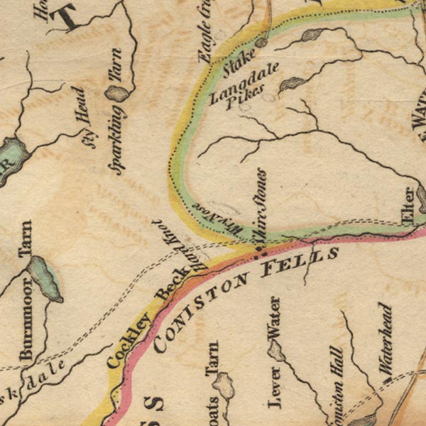 Ws02NY20.jpg On the meeting of the three county boundaries; there are three dots by the label. item:- Armitt Library : A1221.1 Image © see bottom of page |
|
|
|
||
| evidence:- | old text:- Camden 1789 (Gough Additions) |
|
| source data:- | Book, Britannia, or A Chorographical Description of the Flourishing Kingdoms of England,
Scotland, and Ireland, by William Camden, 1586, translated from the 1607 Latin edition
by Richard Gough, published London, 1789. Page 179:- "..." "In Langdale in Westmorland are two high hills in the road from Cumberland to Gresmere called Hardknot and Wrynose; on the latter of which are placed the shire stones; three little stones, about a foot high and a foot asunder, set in a triangle." |
|
|
|
||
| evidence:- | descriptive text:- Otley 1823 (5th edn 1834) |
|
| source data:- | Guide book, A Concise Description of the English Lakes, the
mountains in their vicinity, and the roads by which they may be
visited, with remarks on the mineralogy and geology of the
district, by Jonathan Otley, published by the author, Keswick,
Cumberland now Cumbria, by J Richardson, London, and by Arthur
Foster, Kirkby Lonsdale, Cumbria, 1823; published 1823-49,
latterly as the Descriptive Guide to the English Lakes. goto source Page 1:- "..." "THE Mountainous District, in which the English Lakes are situated, extends into three Counties, Cumberland, Westmorland, and Lancashire, which form their junction at a point upon the mountain Wrynose, near the road side. ..." goto source"... Near the road on Wrynose are the three shire stones of Cumberland, Westmorland, and Lancashire." |
|
|
|
||
| evidence:- | old text:- Gents Mag |
|
| source data:- | Magazine, The Gentleman's Magazine or Monthly Intelligencer or
Historical Chronicle, published by Edward Cave under the
pseudonym Sylvanus Urban, and by other publishers, London,
monthly from 1731 to 1922. goto source Gentleman's Magazine 1825 part 1 p.516 "Compendium of County History. - Westmorland." "Upon WRYNOSE HILL are placed the Shire-stones, in a triangle a foot from each other, where Westmorland, Cumberland, and Lancashire, meet in a point." |
|
|
|
||
| evidence:- | old drawing:- Aspland 1840s-60s placename:- Three Shire Stones |
|
| source data:- | Drawing, pencil and ink wash, the Three Shire Stones, Wrynose, Westmorland, Cumberland,
and Lancashire, by Theophilus Lindsey Aspland, 16 September 1852.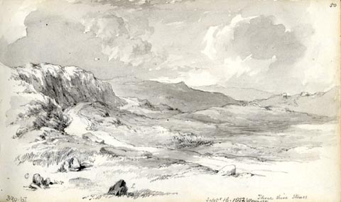 click to enlarge click to enlargeAS0367.jpg "Three Shire Stones / Septr 16. 1852 Wrynose" "C / W / L" page number "50" item:- Armitt Library : 1958.390.67 Image © see bottom of page |
|
|
|
||
| evidence:- | old map:- Garnett 1850s-60s H placename:- Three Shire Stones |
|
| source data:- | Map of the English Lakes, in Cumberland, Westmorland and
Lancashire, scale about 3.5 miles to 1 inch, published by John
Garnett, Windermere, Westmorland, 1850s-60s.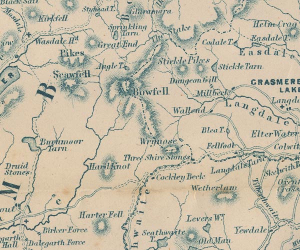 GAR2NY20.jpg "Three Shire Stones" block; at meet of county boundaries item:- JandMN : 82.1 Image © see bottom of page |
|
|
|
||
| evidence:- | old text:- Martineau 1855 item:- shire stone |
|
| source data:- | Guide book, A Complete Guide to the English Lakes, by Harriet
Martineau, published by John Garnett, Windermere, Westmorland,
and by Whittaker and Co, London, 1855; published 1855-76. goto source Page 115:- "... The travellers are now in Westmorland; but at the three shire stones at the top [of Wrynose], where three counties meet, they will step into Lancashire, in order to leave it for Cumberland at Cockley Beck bridge, within three miles further on. We are glad to hear that a spirited citizen of Ambleside, to whom his neighbours are under great obligations, is erecting a stone pillar at the spot where the shire stones are, that the junction of counties may not be overlooked (as it easily may be now) by the unobservant traveller. Young tourists, who happen to have long limbs, may enjoy the privilege of being in three counties at once, by setting their feet on two of the three stones, and resting their hands on the third. ..." |
|
|
|
||
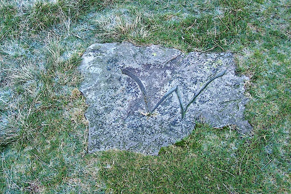
| observation:- |
Three stones are set flat in the ground, each with a letter for a county; Lancashire,
Cumberland, and Westmorland: these are replacements for the originals, set here in
the mid 20th century. The stone you see in passing is not one of the shire stones;
It is sad that a personal memorial has taken over the site. |
|
|
|
||
Lakes Guides menu.