 Old Cumbria Gazetteer
 |
 |
|
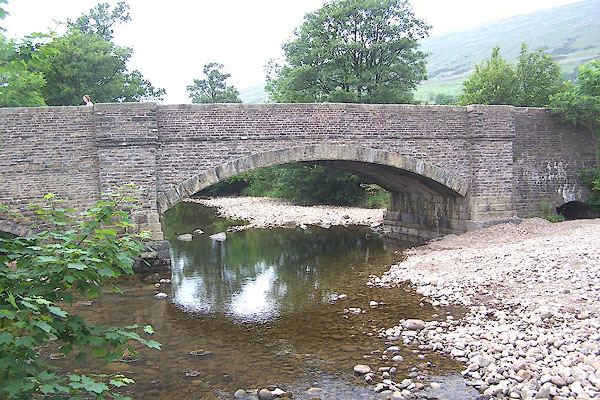
| Church Bridge, Dent | ||
| Church Bridge | ||
| site name:- | Dee, River | |
| locality:- | Dent | |
| civil parish:- | Dent (formerly Yorkshire) | |
| county:- | Cumbria | |
| locality type:- | bridge | |
| coordinates:- | SD70758716 | |
| 1Km square:- | SD7087 | |
| 10Km square:- | SD78 | |
|
|
||
 BMG72.jpg (taken 16.6.2006) |
||
|
|
||
| evidence:- | old map:- OS County Series (Yrk 64 13) placename:- Church Bridge |
|
| source data:- | Maps, County Series maps of Great Britain, scales 6 and 25
inches to 1 mile, published by the Ordnance Survey, Southampton,
Hampshire, from about 1863 to 1948. |
|
|
|
||
| evidence:- | database:- Listed Buildings 2010 placename:- Church Bridge |
|
| source data:- | courtesy of English Heritage "CHURCH BRIDGE / / CHURCH BRIDGE / DENT / SOUTH LAKELAND / CUMBRIA / II / 484237 / SD7075487164" |
|
| source data:- | courtesy of English Heritage "Public road bridge over River Dee. Probably late C18. Coursed sandstone rubble with hammer-dressed plinths and voussoirs, chiselled coping to parapets. Wide segmental arch with dressed voussoirs, springing from broad terminal piers with stepped plinths; string course to parapets. Long ramp abutments to east and west, that to the west with a low stilted segmental-arched flood sluice under it." |
|
|
|
||
 Lakes Guides menu.