 Old Cumbria Gazetteer
 |
 |
|
| Hangman's Close, Carlisle | ||
| Hangman's Close | ||
| civil parish:- | Carlisle (formerly Cumberland) | |
| county:- | Cumbria | |
| locality type:- | locality | |
| locality type:- | gallows (site of) | |
| coordinates:- | NY39985642 (about) | |
| 1Km square:- | NY3956 | |
| 10Km square:- | NY35 | |
|
|
||
| evidence:- | old map:- Smith 1752 placename:- Hangmans Close |
|
| source data:- | Map, hand coloured engraving, or manuscript? Map of the Soccage
Lands at Carlisle, scale about 27 ins to 1 mile, by George
Smith, 1752.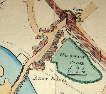 click to enlarge click to enlargeM005P2.jpg "HANGMANS CLOSE" item:- Carlisle Library : Map 121 Image © Carlisle Library |
|
|
|
||
 Lakes Guides menu.