 Old Cumbria Gazetteer
 |
 |
|
| Court Thorn, Hesket | ||
| Court Thorn | ||
| civil parish:- | Hesket (formerly Cumberland) | |
| county:- | Cumbria | |
| locality type:- | tree | |
| locality type:- | thorn | |
| locality type:- | court | |
| locality type:- | manor court | |
| coordinates:- | NY46924562 (guess) | |
| 1Km square:- | NY4645 | |
| 10Km square:- | NY44 | |
|
|
||
| evidence:- | old map:- OS County Series (Cmd 31 14) placename:- Court Thorn |
|
| source data:- | Maps, County Series maps of Great Britain, scales 6 and 25
inches to 1 mile, published by the Ordnance Survey, Southampton,
Hampshire, from about 1863 to 1948. "Court Thorn" no symbol, a ?tree |
|
|
|
||
| evidence:- | old map:- Unknown 1910s placename:- Court Thorn |
|
| source data:- | Map, ms black and colour inks, Tarn Wadling and area, Hesket,
Cumberland, scale about 6 ins to 1 mile.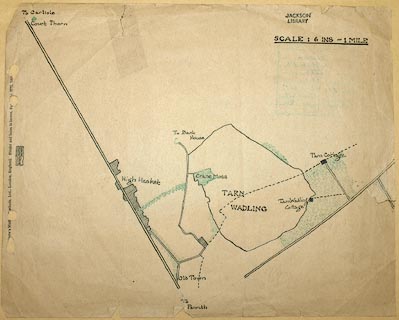 click to enlarge click to enlargeM043.jpg item:- Carlisle Library : Map 304 Image © Carlisle Library |
|
|
|
||
| hearsay:- |
The stone platform here had a hole in the middle through which grew a thorn tree.
This was the site of the manor court. |
|
|
|
||
 Lakes Guides menu.