 Old Cumbria Gazetteer
 |
 |
|
| guide stone, Alston | ||
| locality:- | Townfoot | |
| locality:- | Alston | |
| civil parish:- | Alston Moor (formerly Cumberland) | |
| county:- | Cumbria | |
| locality type:- | guide stone | |
| coordinates:- | NY71744648 | |
| 1Km square:- | NY7146 | |
| 10Km square:- | NY74 | |
|
|
||
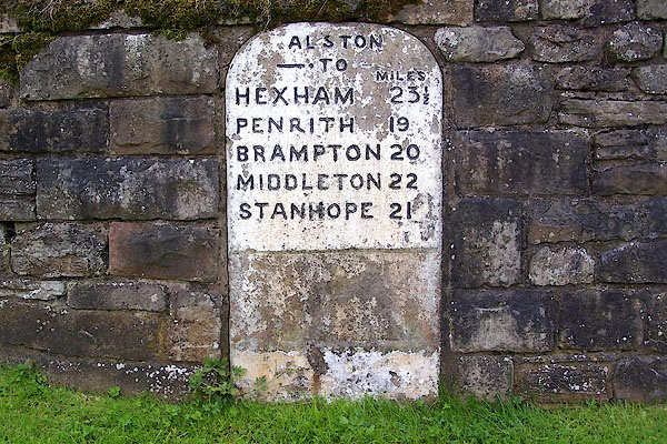 BOK08.jpg Inscribed stone:- "ALSTON TO / MILES / HEXHAM 25½/ PENRITH 19 / BRAMPTON 20 / MIDDLETON 22 / STANHOPE 21" (taken 9.7.2007) |
||
|
|
||
| evidence:- | database:- Listed Buildings 2010 |
|
| source data:- | courtesy of English Heritage "MILESTONE SET INTO ROUNDED CORNER OF WALL TO WEST OF TOWN HALL / / FRONT STREET / ALSTON MOOR / EDEN / CUMBRIA / II / 73115 / NY7173746484" |
|
| source data:- | courtesy of English Heritage "Milestone, early C19 for Alston Turnpike Trust. Single stone c4 ft high by c2 ft wide with elliptical top; set into wall with only face showing. Painted white with carved sans-serif lettering picked out in black: ALSTON. TO HEXHAM 23 1/2 MILES, PENRITH 19, BRAMPTON 20, MIDDLETON 22, STANHOPE 21." |
|
|
|
||
 Lakes Guides menu.