 Old Cumbria Gazetteer
 |
 |
|
| Ashgill Force, Alston Moor | ||
| Ashgill Force | ||
| site name:- | Ash Gill | |
| locality:- | Ashgill | |
| civil parish:- | Alston Moor (formerly Cumberland) | |
| county:- | Cumbria | |
| locality type:- | waterfall | |
| coordinates:- | NY75864048 | |
| 1Km square:- | NY7540 | |
| 10Km square:- | NY74 | |
|
|
||
| evidence:- | old map:- OS County Series (Cmd 42 10) placename:- Ashgill Force |
|
| source data:- | Maps, County Series maps of Great Britain, scales 6 and 25
inches to 1 mile, published by the Ordnance Survey, Southampton,
Hampshire, from about 1863 to 1948. |
|
|
|
||
| evidence:- | old map:- Ford 1839 map |
|
| source data:- | Map, uncoloured engraving, Map of the Lake District of
Cumberland, Westmoreland and Lancashire, scale about 3.5 miles
to 1 inch, published by Charles Thurnam, Carlisle, and by R
Groombridge, 5 Paternoster Row, London, 3rd edn 1843.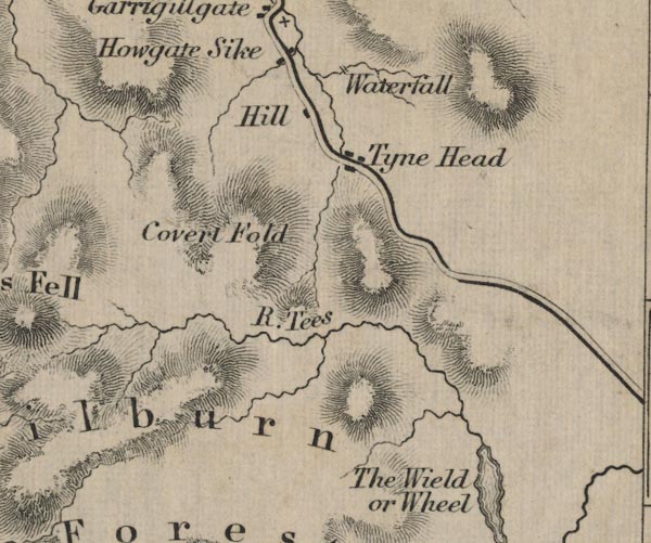 FD02NY73.jpg "Waterfall" 2 lines across stream. item:- JandMN : 100.1 Image © see bottom of page |
|
|
|
||
| evidence:- | old print:- Wallace 1861 placename:- Ashgill Force |
|
| source data:- | Print, lithograph, Ashgill Force, drawn by William Wallace, published by Edward Stanford,
6 Charing Cross, London, 1861.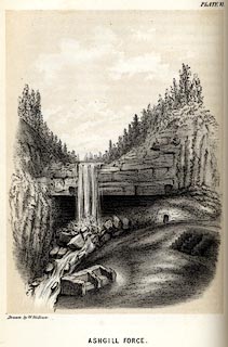 click to enlarge click to enlargeWC0106.jpg Plate 6, tipped in opposite p.41 of The Laws which Regulate the Deposit of Lead Ore in Veins. printed at bottom left, centre:- "Drawn by W. Wallace. / ASHGILL FORCE." item:- private collection : 159.3 Image © see bottom of page |
|
|
|
||
 Lakes Guides menu.