 Old Cumbria Gazetteer
 |
 |
|
|
| Karl Lofts, Shap | |||
| Karl Lofts | |||
| civil parish:- | Shap (formerly Westmorland) | ||
| county:- | Cumbria | ||
| locality type:- | stone alignment | ||
| coordinates:- | NY56051502 (etc) | ||
| 1Km square:- | NY5615 | ||
| 10Km square:- | NY51 | ||
| SummaryText:- | This supposed alignment of standing stones hardly exists now. | ||
|
|
|||
| evidence:- | old map:- OS County Series (Wmd 14 14) placename:- Karl Lofts |
||
| source data:- | Maps, County Series maps of Great Britain, scales 6 and 25
inches to 1 mile, published by the Ordnance Survey, Southampton,
Hampshire, from about 1863 to 1948. |
||
|
|
|||
| evidence:- | descriptive text:- Keer 1605 (edn 1620) |
||
| source data:- | Map, Westmorlandia et Comberlandia, ie Westmorland and
Cumberland now Cumbria, scale about 16 miles to 1 inch, probably
by Pieter van den Keere, or Peter Keer, about 1605, published
about 1605 to 1676. goto source goto sourcethird page "[Shap] ... it is thought that some notable Act of Atchievement hath beene performed there, for that there be huge stones in forme of Pyramides, some nine foot high, and fourteen foote thicke, ranged for a mile in length directly in a row, and equally distant, which might seeme to have beene there purposely pitched in memory thereof: but what that Act was is not now knowne, but quite worne out of remembrance by times iniurie." |
||
|
|
|||
| evidence:- | poem:- Drayton 1612/1622 text |
||
| source data:- | Poem, Poly Olbion, by Michael Drayton, published by published by
John Marriott, John Grismand and Thomas Dewe, and others?
London, part 1 1612, part 2 1622. goto source page 168:- "... So neere to Loders Spring, from thence [Salkeld] not farre away, Be others nine foot high, a myle in length that runne, The victories for which these Trophies were begun, From darke oblivion thou, O Time, shouldst have protected, For mighty were their minds, them thus that first erected: ..." |
||
|
|
|||
| evidence:- | old map:- Drayton 1612/1622 placename:- Loder Stones |
||
| source data:- | Map, hand coloured engraving, Cumberlande and Westmorlande, by
Michael Drayton, probably engraved by William Hole, scale about
4 or 5 miles to 1 inch, published by John Mariott, John
Grismand, and Thomas Dewe, London, 1622.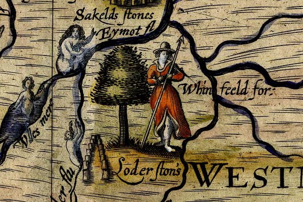 DRY511.jpg "Loder ston's" Double row of standing stones. item:- JandMN : 168 Image © see bottom of page |
||
|
|
|||
| evidence:- | old text:- Camden 1789 |
||
| source data:- | Book, Britannia, or A Chorographical Description of the Flourishing Kingdoms of England,
Scotland, and Ireland, by William Camden, 1586, translated from the 1607 Latin edition
by Richard Gough, published London, 1789. goto source Page 148:- "... [near] Shape, ... several huge stones of a pyramidal form, some of them nine feet high, and four thick, standing in a row for near a mile at an equal distance, which seem to have been erected in memory of some transaction there, which by length of time is lost. ..." |
||
|
|
|||
| evidence:- | old text:- Camden 1789 (Gough Additions) |
||
| source data:- | Book, Britannia, or A Chorographical Description of the Flourishing Kingdoms of England,
Scotland, and Ireland, by William Camden, 1586, translated from the 1607 Latin edition
by Richard Gough, published London, 1789. goto source Page 161:- "..." "... At the S. end of the village [Shap] on a common near the road side is an area upwards of half a mile long and between 20 and 30 yards broad, of small stones, and parallel to the road begins a double row of immense granites three or four yards diameter and 8 10 or 12 yards asunder, crossed at the end by another row; all placed at some distance from each other. This alley extended within memory above a mile quite through the village, since removed to clear the ground. The space between the lines at the south-east is 80 feet, but near Shap only 59, so that they probably met at last in a point. At the upper end is a circle of the like stones 18 feet diameter. ..." |
||
|
|
|||
| evidence:- | old text:- Capper 1808 |
||
| source data:- | Gazetteer, A Topographical Dictionary of the United Kingdom,
compiled by Benjamin Pitts Capper, published by Richard
Phillips, Bridge Street, Blackfriars, London, 1808; published
1808-29. goto source "[Shap] ... In the neighbourhood are many vast stones, like pyramids, placed almost in a direct line for a mile together, from 10 to 12 yards distance, of such an immense weight that carriages now in use could not move them: they are supposed to have belonged to the Druids. ..." |
||
|
|
|||
| evidence:- | old text:- Gents Mag |
||
| source data:- | Magazine, The Gentleman's Magazine or Monthly Intelligencer or
Historical Chronicle, published by Edward Cave under the
pseudonym Sylvanus Urban, and by other publishers, London,
monthly from 1731 to 1922. goto source Gentleman's Magazine 1824 part 1 p.3 "CARL LOFTS AT SHAP, WESTMORELAND." "Rosegill, Jan. 12." "Mr. URBAN," "AT Shap is a stupendous monument of antiquity called Carl Lofts, i.e. "the liftings of the Ceorles or husbandmen." It is composed of two rows of large stones of unhewn granite, from six to twelve feet in diameter. The form is a gentle curve, or something like the head of a well-formed mason's hammer. It commences about half a mile south of the town, and runs parallel with the Kendal road, on the east side, for about three quarters of a mile, when it turns off in a north-west direction for about the length of a mile and three quarters, or perhaps about three thousand yards. At the south end, about twenty yards from the south-west corner, on the outside of the stones, was a small tumulus, which, since the inclosure of Shap common in 1815, is now levelled and destroyed. When this tumulus was opened into, it was found to be composed of granite and cobble stone: as the strata of stone here is lime-stone, the granite must have been gathered on the surrounding surface, and the cobble must have been brought from some distance. At about the distance of 100 yards from the turn at the south end, on the outside, was a circle about eighteen feet in diameter of similar stones, each about one yard and a half in diameter, and in the centre thereof was one about one yard and a half high from the surface of the ground that tapered to a point. This has also been destroyed since the inclosure of the common." "The distance of the stones in the lines was eight, ten, or twelve yards; but at the turn at the south end, which remains perfect, they are something nearer, being from three to eight yards. The distance between each line at the south end is eighty-nine feet. This distance seems gradually to have diminished about one yard in every hundred, till it came to a wedge-like point at the north end, near to the field called Skellaw. In this field called Skellaw, which signifies "the hill of the skulls," is a small tumulus on an eminence, which no doubt is connected with the monument, though it deviates about 190 yards to the north-east from the last stone now remaining; but it highly probable the stones were continued a little further northward; this deviation, however, may be accounted for from the eligibility of the situation for prospect, as from this spot the tumulus at the south end could be seen, and nearly the whole line of the monument." "A few years ago a countryman wanting stones for the highway, dug into this tumulus, thinking to find stone; but not finding the appearance of any, he soon desisted. In his attempt, however, he found human bones." "When the antiquary now views the remains of this remarkable monument, he cannot but regret at what, perhaps, he may call the barbarous treament it has met with. The southern end, which extended about half a mile on the common, had both rows tolerably perfect till the inclosure of the common in 1815; since then these stones have nearly all been blasted and removed into the walls, excepting fourteen, which compose the turn at the south end, which are on a plot of land alloted to the Earl of Lonsdale, and which he has given orders to be preserved. The northern end, for nearly the length of a mile, lying amongst old inclosed and arable land, had generally been removed at former periods before the recollection of any person now living. There are, however, four on a piece of land, which cannot be tilled for limestone rock, which seem to form the terminating point, or at least part of it, at the north end. They are respectively 11, 25, and 20 yards distant from each other. Probably two may have been" |
||
| source data:- | goto source Gentleman's Magazine 1824 part 1 p.4 "removed from among these, as the two latter distances seem to admit of such a supposition. Between these four and the fourteen at the south end, only fifteen now remain in their original position. They are left here and there, and serve as a sort of guide to trace the course of the monument. The blasted and broken fragments of the others maya be seen in the walls adjoining." "... Guggleby stone, ... The stone next remaining [Asper's Field Stone] ..." "These masses of granite were, no doubt, originally from Wastdale, which is about two miles from the south end of the monument: for here a bed of similar granite is found, the only bed I believe in Westmoreland. It is remarkable that, for the distance of three miles eastward from the low end of Wastdale, an immense quantity of rounded worn-like granite stones of all sizes, up to four yards in diameter, are found scattered over the face of the country to the above distance or further, which is wholly of a limestone and freestone strata. They seem to be spread in a fan-like form from Wastdale, and are more thickly scattered, and also of smaller size, as the distance increases. These primary stones being found on the surface of secondary ones, demonstrate that they have been thus thrown by some convulsion of nature of which we have no record; or, according to Professor Buckland, in his Reliquiae Diluvianae on similar appearances, they have thus been transported and drifted by a diluvial current. He, indeed, supposes, that a diluvial current is the only adequate cause that can account for these appearances. See also Edin. Rev. for Oct. 1823, No.77." "Whether the stones which composed the Carl Lofts were brought direct from Wastdale, or whether they were gathered from among the scattered ones, can only now be a mater of conjecture; but probably they were some of the scattered ones; as they might be found nearer for carriage and already detached. But how such immense blocks (several being from 3 to 4 yards in diameter) could be carried and placed in the regular manner they were, it is difficult to form an idea." ""That the monument was Danish, may be inferred from the custom of the northern nations of arranging their recording stones in forms that they seemed to determine should be expressive of certain events; those that were placed in straight and long order commemorated the emulations of champions: squares shewed equestrian conflicts: circles the interments of families: wedge-shaped a fortunate victory."* Pennant agrees in this opinion, and supposes that "success might have attended the northern invaders in this place, which gave rise to their long arrangement."†Hence, if this be correct, they have been placed here between eight or nine hundred years. Dr. Burn in his History of Westmoreland, says, "undoubtedly this hath been a place of Druid worship, which they always performed in the open air within this kind of inclosure, shaded with wood, as this place of old time appears to have been, although there is now scarce a tree to be seen, (Shap Thorn only excepted, planted on the top of a hill for the direction of travellers). At the high end of this place of worship, there is a circle of the like stones about 18 feet in diameter, which was their sanctum sanctorum, as it were, and place of sacrifice." But Dr. Burn seems only to have taken a limited view of the monument. He only speaks of the south end upon the com-" "*Olaus Magnus de Gent. Septentr. l.1. c.18." " †Pennant's Northern Tour, i. 297." |
||
| source data:- | goto source Gentleman's Magazine 1824 part 1 p.5 "[com]mon, which was perfect in his day, and does not appear to have traced its extent northward through the old inclosed land. That so extensive a space as is here occupied should have any reference to a place of worship, seems hardly probable. That it was to commemorate some event, and probably a victory, seems more likely, and the name of Skellaw, i.e. the Hill of Skulls, strengthens the conjecture." "GEORGE HALL." "... ..." |
||
|
|
|||
| evidence:- | old text:- Gents Mag placename:- Stones of Shap item:- site plan |
||
| source data:- | Magazine, The Gentleman's Magazine or Monthly Intelligencer or
Historical Chronicle, published by Edward Cave under the
pseudonym Sylvanus Urban, and by other publishers, London,
monthly from 1731 to 1922. goto source Gentleman's Magazine 1833 part 1 p.4 "Jan. 13." "Mr. URBAN," "IN the Reliquiae Galeanae, p.387, is the subjoined interesting passage, in a letter dated Stamford, Sept. 24, 1743, from Dr. Stukeley to Mr. Gale:" "'I have got a vast drawing and admeasurement, from Mr. Routh of Carlisle, of the Stones of Shap' (in Westmoreland,) 'which I desired from him. They give me so much satisfaction that verily I shall call on you next year to take another religious pilgrimage with me thither. I find it to be, what I always supposed, another huge serpentine temple, like that of Aubury. The measure of what are left extends a mile and a half, but, without a doubt, a great deal of it has been demolished by the town, abbey, and every thing else thereabouts.'" "I send you the above for insertion in your Magazine, with the hope that some of your correspondents may be able to inform you whether the drawing and plan which it mentions, were ever published or not: if they were, in what work? and if not - whether they exist, and where?" "The inclosure of Shap Fell made sad havoc in the temple. Traces of it, however, still exist, and the recovery of Mr. Routh's plans might go far to find out its original form, and throw much light upon the history of the neighbourhood, which abounds in Druidical remains." "Dr. Stukeley is certainly right in calling the whole collection of stones a temple. It is not, as has been commonly and idly conjectured, a Danish monument. Similar works abound in parts of Wales, Ireland, and Scotland, where the Danes never settled. Neither is there any evidence, or probable ground of conjecture, that the Danes ever erected any such monuments in Britain as this. They were too intent upon plunder and securing their conquests, to have either time or inclination to get up monuments in their glory." "It is a remarkable feature of Westmoreland and Cumberland, that their uncultivated hills and plains are scattered all over with Druidical remains; while in Northumberland and Durham, which adjoin them on the east, scarcely anything of the kind exists. There is, indeed, good historical evidence to show, that Cumberland and Westmoreland were inhabited by the Celtic race, called Cumbri, or Cimmerii, for several centuries after the Romans left Britain; whereas the eastern shores of the island, in Northumberland and Durham, were inhabited by German tribes before the Roman aera. The rude masses of stone, of which the temple is made, consist chiefly of the granite and grauwacke, which abound in the mountains to the west of Shap. ..." |
||
|
|
|||
| evidence:- | descriptive text:- Ford 1839 (3rd edn 1843) placename:- Karl Lofts |
||
| source data:- | Guide book, A Description of Scenery in the Lake District, by
Rev William Ford, published by Charles Thurnam, Carlisle, by W
Edwards, 12 Ave Maria Lane, Charles Tilt, Fleet Street, William
Smith, 113 Fleet Street, London, by Currie and Bowman,
Newcastle, by Bancks and Co, Manchester, by Oliver and Boyd,
Edinburgh, and by Sinclair, Dumfries, 1839. goto source Page 141:- "..." "Near the town of Shap is a stupendous monument, called Karl Lofts, composed of two lines of huge unhewn masses of granite, enclosing an area of half-a-mile in length, and from twenty to thirty yards in breadth, having at its south end a circle of similar stones, eighteen feet in diameter, and near the north end a square plot of stones, partly covered with earth, above which, on Skellaw Hill, is a small tumulus. The stones in each line are some of them three or four yards in diameter; but many of them have been blasted and carried away for the erection of buildings in the parish." |
||
|
|
|||
| mapping:- | Thunder Stone, Shap tumulus, Skellaw Hill Asper's Field Stone, Shap Goggleby Stone, Shap standing stone, Shap standing stone, Shap (2) standing stone, Shap (3) standing stone, Shap (4) Kemp Howe stone circle, Shap |
||
|
|
|||
Lakes Guides menu.