 Old Cumbria Gazetteer
 |
 |
|
| milestone, Westnewton | ||
| site name:- | road, Wigton to Workington | |
| civil parish:- | Westnewton (formerly Cumberland) | |
| county:- | Cumbria | |
| locality type:- | milestone | |
| coordinates:- | NY10794336 | |
| 1Km square:- | NY1043 | |
| 10Km square:- | NY14 | |
|
|
||
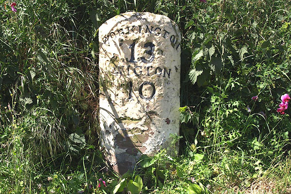 BPI17.jpg Inscribed stone:- "WORKINGTON / 13 / WIGTON / 10" (taken 14.3.2008) |
||
|
|
||
| evidence:- | old map:- OS County Series (Cmd 35 3) placename:- |
|
| source data:- | Maps, County Series maps of Great Britain, scales 6 and 25
inches to 1 mile, published by the Ordnance Survey, Southampton,
Hampshire, from about 1863 to 1948. "M.S Workington .. 13 Wigton .. 10" |
|
|
|
||
| evidence:- | database:- Listed Buildings 2010 |
|
| source data:- | courtesy of English Heritage "MILESTONE SOUTH EAST OF NEWTON FIELD / / / WESTNEWTON / ALLERDALE / CUMBRIA / II / 412701 / NY1079643358" |
|
| source data:- | courtesy of English Heritage "Milestone. Late C18 or early C19 for the Wigton-Workington Turnpike. Whitewashed stone. Round-topped stone inscribed on front WORKINGTON 13, WIGTON 10." |
|
|
|
||
 Lakes Guides menu.