 Old Cumbria Gazetteer
 |
 |
|
| Holyfield Sun Vein Lead Mine, Alston Moor | ||
| Holyfield Sun Vein Lead Mine | ||
| locality:- | Nattrass | |
| civil parish:- | Alston Moor (formerly Cumberland) | |
| county:- | Cumbria | |
| locality type:- | lead mine | |
| locality type:- | mine | |
| coordinates:- | NY734447 | |
| 1Km square:- | NY7344 | |
| 10Km square:- | NY74 | |
|
|
||
| evidence:- | old map:- Dickinson and Sopwith 1828 |
|
| source data:- | Mine plan, and section, hand coloured engraving, Holyfield Sun
Vein Lead Mine, Nattrass, Alston Moor, Cumberland, scale about
37 ins to 1 mile, by J Dickinson and T Sopwith, 1828.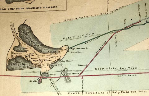 click to enlarge click to enlargeM002P.jpg item:- Carlisle Library : Map 49 Image © Carlisle Library |
|
|
|
||
| evidence:- | old map:- Dickinson and Sopwith 1828 |
|
| source data:- | Building plan, uncoloured engraving, Plan and Elevation of a
Bridge ... over the River Eden at Carlisle, Cumberland, scale
about 1 to 122, by Thomas Telford, 1808, engraved by James
Basire, published by Parliament, London, 1809.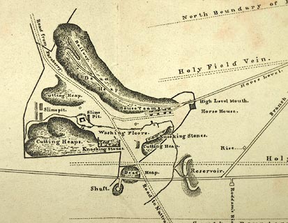 click to enlarge click to enlargeM041P.jpg 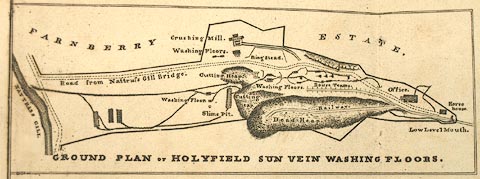 click to enlarge click to enlargeM041P2.jpg item:- Carlisle Library : Map 249 Images © Carlisle Library |
|
|
|
||
 Lakes Guides menu.