 Old Cumbria Gazetteer
 |
 |
|
| Crosby Turnpike, Stanwix Rural | ||
| gone | ||
| Crosby Turnpike | ||
| site name:- | road, Carlisle to Brampton N | |
| locality:- | Low Crosby (near) | |
| civil parish:- | Stanwix Rural (formerly Cumberland) | |
| county:- | Cumbria | |
| locality type:- | toll gate (site) | |
| coordinates:- | NY43865953 | |
| 1Km square:- | NY4359 | |
| 10Km square:- | NY45 | |
| references:- | OS County Series |
|
|
|
||
| evidence:- | old map:- OS County Series (Cmd 17 9) |
|
| source data:- | Maps, County Series maps of Great Britain, scales 6 and 25
inches to 1 mile, published by the Ordnance Survey, Southampton,
Hampshire, from about 1863 to 1948. "Crosby T.P." no gate is shown, just a building |
|
|
|
||
| evidence:- | old map:- Donald 1774 (Cmd) |
|
| source data:- | Map, hand coloured engraving, 3x2 sheets, The County of Cumberland, scale about 1
inch to 1 mile, by Thomas Donald, engraved and published by Joseph Hodskinson, 29
Arundel Street, Strand, London, 1774.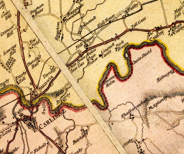 D4NY45NW.jpg "Toll Gate" block by road; toll house and toll gate item:- Carlisle Library : Map 2 Image © Carlisle Library |
|
|
|
||
 Lakes Guides menu.