 Old Cumbria Gazetteer
 |
 |
|
| Killhope Cross, Alston Moor | ||
| Killhope Cross | ||
| locality:- | road, Alston to Barnard Castle | |
| civil parish:- | Alston Moor (formerly Cumberland) | |
| county:- | Cumbria | |
| locality type:- | cross | |
| locality type:- | county boundary mark | |
| locality type:- | boundary mark | |
| coordinates:- | NY79934323 | |
| 1Km square:- | NY7943 | |
| 10Km square:- | NY74 | |
| county:- | Durham | |
| old boundary | ||
| locality:- | Cumberland boundary | |
| current boundary | ||
| locality:- | Cumbria boundary | |
| references:- | OS County Series |
|
|
|
||
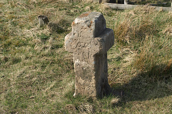 BUJ90.jpg (taken 23.4.2011) |
||
|
|
||
| evidence:- | old map:- OS County Series (Cmd 42 4) placename:- Killhope Cross |
|
| source data:- | Maps, County Series maps of Great Britain, scales 6 and 25
inches to 1 mile, published by the Ordnance Survey, Southampton,
Hampshire, from about 1863 to 1948. "Killhope Cross" on boundary |
|
|
|
||
| evidence:- | old map:- Donald 1774 (Cmd) placename:- Killhope Cross |
|
| source data:- | Map, hand coloured engraving, 3x2 sheets, The County of Cumberland, scale about 1
inch to 1 mile, by Thomas Donald, engraved and published by Joseph Hodskinson, 29
Arundel Street, Strand, London, 1774.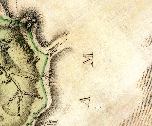 D4NY84SW.jpg "Killhope Cross" cross on county boundary item:- Carlisle Library : Map 2 Image © Carlisle Library |
|
|
|
||
| evidence:- | old map:- Cooke 1802 placename:- Kilhope Cross |
|
| source data:- | Map, Cumberland, scale about 15.5 miles to 1 inch, by George
Cooke, 1802, bound in Gray's New Book of Roads, 1824, published
by Sherwood, Jones and Co, Paternoster Road, London, 1824. click to enlarge click to enlargeGRA1Cd.jpg "Kilhope Cro" locality item:- Hampshire Museums : FA2000.62.2 Image © see bottom of page |
|
|
|
||
| evidence:- | database:- Listed Buildings 2010 placename:- Killhope Cross |
|
| source data:- | courtesy of English Heritage "KILLHOPE CROSS / / A689 / ALSTON MOOR / EDEN / CUMBRIA / II / 73097 / NY7993043231" |
|
| source data:- | courtesy of English Heritage "Boundary marker of uncertain date but possibly medieval; moved to its present site in C18. Single stone, c3 ft high, in form of Latin cross; stands on square base bearing bench mark. Carved lettering on all faces, much weathered. On border between Cumbria and County Durham." |
|
|
|
||
 Lakes Guides menu.