 Old Cumbria Gazetteer
 |
 |
|
| milestone, Irthington (4) | ||
| site name:- | road, Carlisle to Brampton N | |
| civil parish:- | Irthington (formerly Cumberland) | |
| county:- | Cumbria | |
| locality type:- | milestone | |
| coordinates:- | NY49195999 | |
| 1Km square:- | NY4959 | |
| 10Km square:- | NY45 | |
| references:- | OS County Series |
|
|
|
||
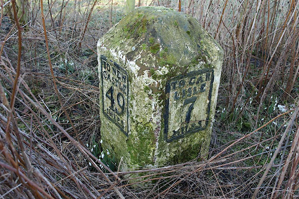 BSE05.jpg Cast iron plates on stone:- "TO NEW / CASTLE / 49 / MILES" "TO CAR / LISLE / 7 / MILES" (taken 19.2.2010) |
||
|
|
||
| evidence:- | old map:- OS County Series (Cmd 17 11) placename:- |
|
| source data:- | Maps, County Series maps of Great Britain, scales 6 and 25
inches to 1 mile, published by the Ordnance Survey, Southampton,
Hampshire, from about 1863 to 1948. "M.S Newcastle .. 49 Carlisle .. 7" |
|
|
|
||
| evidence:- | database:- Listed Buildings 2010 |
|
| source data:- | courtesy of English Heritage "MILESTONE AT NATIONAL GRID REFERENCE NY 49170 59980 / / / IRTHINGTON / CARLISLE / CUMBRIA / II / 77912 / NY4918059994" |
|
| source data:- | courtesy of English Heritage "Milestone. Probably 1758, for the Carlisle-Newcastle Military Road. Sandstone, cast-iron plates. Chamfered stone to give 2 faces in direction of traffic, one face with cast plate in 4 lines CARLISLE 7 MILES, other face TO NEWCASTLE 49 MILES in 4 lines. Whitewashed over and lettering picked-out in black. In 1811 the road became the Carlisle-Temon Turnpike. Each milestone is clearly drawn on Hodgkinson and Donalds map of Cumberland and Westmorland, surveyed 1770." |
|
|
|
||
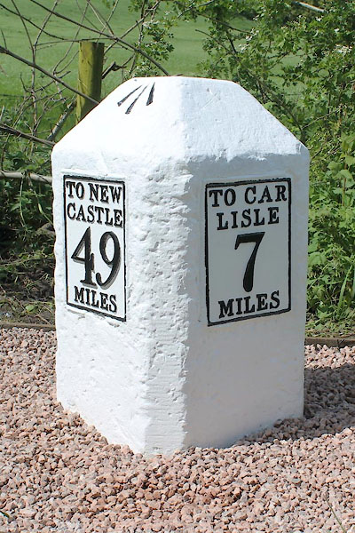 CEL77.jpg Cast iron plates on stone:- "TO NEW / CASTLE / 49 / MILES" "TO CAR / LISLE / 7 / MILES" (taken 11.5.2014) courtesy of Terry Moore Image © Terry Moore |
||
|
|
||
 Lakes Guides menu.