 Old Cumbria Gazetteer
 |
 |
|
| Roose Gates, Roose | ||
| gone | ||
| Roose Gates | ||
| site name:- | Furness Railway | |
| locality:- | Old Roose | |
| civil parish:- | Barrow-in-Furness (formerly Lancashire) | |
| county:- | Cumbria | |
| locality type:- | level crossing (once) | |
| locality type:- | railway station | |
| coordinates:- | SD22066971 | |
| 1Km square:- | SD2269 | |
| 10Km square:- | SD26 | |
|
|
||
| evidence:- | old map:- OS County Series (Lan 21 8) placename:- Roose Gates |
|
| source data:- | Maps, County Series maps of Great Britain, scales 6 and 25
inches to 1 mile, published by the Ordnance Survey, Southampton,
Hampshire, from about 1863 to 1948.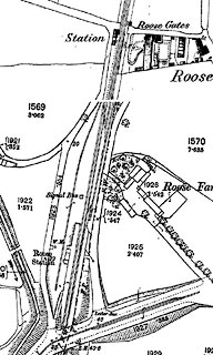 click to enlarge click to enlargeCSRY0137.jpg "Station / Roose Gates" level crossing, and station in the SW angle of the road,rail crossing; the relocated station to the south on a later date sheet |
|
|
|
||
 Lakes Guides menu.