 Old Cumbria Gazetteer
 |
 |
|
| Castle Head Hill, Meathop and Ulpha | ||
| Castle Head Hill | ||
| locality:- | Castle Head | |
| civil parish:- | Meathop and Ulpha (formerly Westmorland) | |
| county:- | Cumbria | |
| locality type:- | hill | |
| coordinates:- | SD42137968 | |
| 1Km square:- | SD4279 | |
| 10Km square:- | SD47 | |
| altitude:- | 121 feet | |
| altitude:- | 37m | |
|
|
||
| evidence:- | old print:- Ayton and Daniell 1814-25 item:- seagull; obelisk |
|
| source data:- | Print, hand coloured aquatint, Castlehead, Westmoreland, drawn and engraved by William
Daniell, probably published by Longman and Co, Paternoster Row, and W Daniell, 9 Cleveland
Street, Fitzroy Square, London, 1816.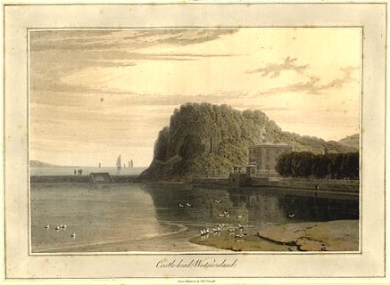 click to enlarge click to enlargePR0779.jpg The view is before the Meathop Embankment was made for the Ulverstone and Lancaster Railway. printed at bottom:- "Castle-head, Westmoreland. / Drawn & Engraved by Willm. Daniell. / Published by Messrs.Longman & Co, Paternoster Row, &W. Daniell, 9 Cleveland St. Fitzroy Square, London, Feby. 1,1816." item:- private collection : 210 Image © see bottom of page |
|
|
|
||
 Lakes Guides menu.