 Old Cumbria Gazetteer
 |
 |
|
| Strand Station, Barrow-in-Furness | ||
| gone | ||
| Strand Station | ||
| site name:- | Furness Railway | |
| locality:- | Barrow-in-Furness | |
| civil parish:- | Barrow-in-Furness (formerly Lancashire) | |
| county:- | Cumbria | |
| locality type:- | railway station | |
| coordinates:- | SD19856884 (?) | |
| 1Km square:- | SD1968 | |
| 10Km square:- | SD16 | |
| SummaryText:- | Opened 1863; closed 1882. | |
|
|
||
| evidence:- | old map:- OS County Series (Lan 21 12) |
|
| source data:- | Maps, County Series maps of Great Britain, scales 6 and 25
inches to 1 mile, published by the Ordnance Survey, Southampton,
Hampshire, from about 1863 to 1948.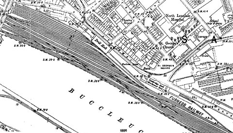 click to enlarge click to enlargeCSRY0132.jpg |
|
|
|
||
| evidence:- | old map:- OS County Series (Lan 21) |
|
| source data:- | Maps, County Series maps of Great Britain, scales 6 and 25
inches to 1 mile, published by the Ordnance Survey, Southampton,
Hampshire, from about 1863 to 1948. "Railway Station" labelled at Cambridge Hall |
|
|
|
||
 Lakes Guides menu.