 Old Cumbria Gazetteer
 |
 |
|
| Piel Station, Roa Island | ||
| gone | ||
| Piel Station | ||
| site name:- | Furness Railway | |
| locality:- | Roa Island | |
| civil parish:- | Barrow-in-Furness (formerly Lancashire) | |
| county:- | Cumbria | |
| locality type:- | railway station | |
| coordinates:- | SD23186494 (etc) | |
| 1Km square:- | SD2364 | |
| 10Km square:- | SD26 | |
|
|
||
| evidence:- | old map:- OS County Series (Lan 28 1) placename:- Piel Station item:- railway signal |
|
| source data:- | Maps, County Series maps of Great Britain, scales 6 and 25
inches to 1 mile, published by the Ordnance Survey, Southampton,
Hampshire, from about 1863 to 1948.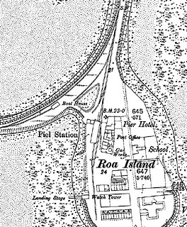 click to enlarge click to enlargeCSRY0136.jpg "Piel Station / S.P. / Boat House" and branch to pier, with a boat house on a siding |
|
|
|
||
 Lakes Guides menu.