 Old Cumbria Gazetteer
 |
 |
|
| Cote House, Whinfell | ||
| gone? | ||
| Cote House | ||
| civil parish:- | Whinfell (formerly Westmorland) | |
| county:- | Cumbria | |
| locality type:- | buildings | |
| coordinates:- | SD57209937 | |
| 1Km square:- | SD5799 | |
| 10Km square:- | SD59 | |
|
|
||
| evidence:- | old map:- Jefferys 1770 (Wmd) placename:- Colt House |
|
| source data:- | Map, 4 sheets, The County of Westmoreland, scale 1 inch to 1
mile, surveyed 1768, and engraved and published by Thomas
Jefferys, London, 1770.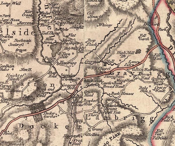 J5SD59NE.jpg "Colt House" circle, labelled in italic lowercase text; settlement, farm, house, or hamlet? item:- National Library of Scotland : EME.s.47 Image © National Library of Scotland |
|
|
|
||
| evidence:- | old map:- Greenwood 1824 placename:- Cote House |
|
| source data:- | Maps, Map of the County of Westmorland, scale about 1 inch to 1
mile, and Map of the County of Cumberland, scale about 1 inch to
1 mile, etc, by C and J Greenwood, published by George Pringle
jnr, 70 Queen Street, Cheapside, London, 1823 and 1824
respectively. "Cote House" |
|
|
|
||
 Lakes Guides menu.