 Old Cumbria Gazetteer
 |
 |
|
| earthwork, Barton | ||
| Tristamont | ||
| Trostormont | ||
| Trostermosit | ||
| Triesmont | ||
| locality:- | Hodgson Hill | |
| civil parish:- | Barton (formerly Westmorland) | |
| county:- | Cumbria | |
| locality type:- | earthwork | |
| coordinates:- | NY46402330 (about) | |
| 1Km square:- | NY4623 | |
| 10Km square:- | NY42 | |
|
|
||
| evidence:- | old map:- Morden 1695 (Wmd) placename:- Trostermont |
|
| source data:- | Map, hand coloured engraving, Westmorland, scale about 2.5 miles to 1 inch, by Robert
Morden, published by Abel Swale, the Unicorn, St Paul's Churchyard, Awnsham, and John
Churchill, the Black Swan, Paternoster Row, London, 1695.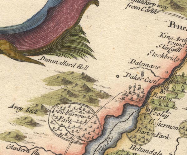 MD10NY42.jpg "Trostermont" Circle and tower, within Barton Park. item:- JandMN : 24 Image © see bottom of page |
|
|
|
||
| evidence:- | probably old map:- Ford 1839 map placename:- Trester Mount |
|
| source data:- | Map, uncoloured engraving, Map of the Lake District of
Cumberland, Westmoreland and Lancashire, scale about 3.5 miles
to 1 inch, published by Charles Thurnam, Carlisle, and by R
Groombridge, 5 Paternoster Row, London, 3rd edn 1843.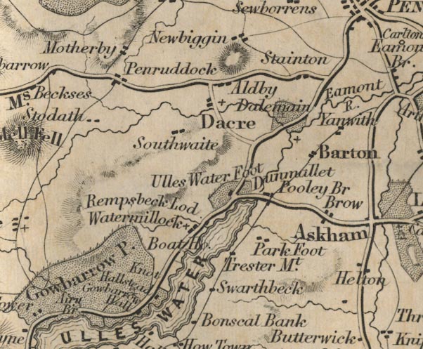 FD02NY42.jpg "Trester Mt." item:- JandMN : 100.1 Image © see bottom of page |
|
|
|
||
| evidence:- | site plan:- Curwen 1913 placename:- Tristermont placename:- Trostermont on Ullswater |
|
| source data:- | Site plan, lithograph, Plan of Tristermont, or Trostermont on Ullswater, at Cross
Dormont, Barton, Westmorland, published for the Cumberland and Westmorland Antiquarian
and Archaeological Society by Titus Wilson, Kendal, Westmorland, 1913.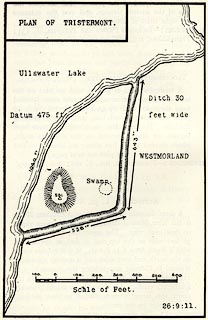 click to enlarge click to enlargeCW0111.jpg On p.48 of The Castles and Fortified Towers of Cumberland, Westmorland, and Lancashire North of the Sands, by John F Curwen. printed at upper left:- "PLAN OF TRISTERMONT." item:- Armitt Library : A782.11 Image © see bottom of page |
|
|
|
||
| hearsay:- |
Said to have been the home of Sir Tristram. |
|
|
|
||
| notes:- |
earthwork |
|
| Perriam, D R &Robinson, J: 1998: Medieval Fortified Buildings of Cumbria: CWAAS::
ISBN 1 873124 23 6; illustration |
||
|
|
||
 Lakes Guides menu.