 Old Cumbria Gazetteer
 |
 |
|
| Hallbankgate Waggonway | ||
| locality:- | Hallbankgate | |
| civil parish:- | Farlam (formerly Cumberland) | |
| county:- | Cumbria | |
| locality type:- | tramroad | |
| locality type:- | inclined plane | |
| coordinates:- | NY57965972 (etc) | |
| 1Km square:- | NY5759 | |
| 10Km square:- | NY55 | |
|
|
||
| evidence:- | old map:- OS County Series (Cmd 18 11) |
|
| source data:- | Maps, County Series maps of Great Britain, scales 6 and 25
inches to 1 mile, published by the Ordnance Survey, Southampton,
Hampshire, from about 1863 to 1948.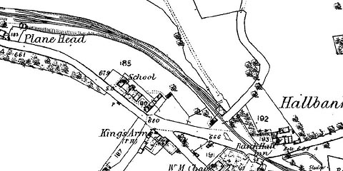 click to enlarge click to enlargeCSRY0009.jpg "Plane Head" at Hallbankgate |
|
|
|
||
 Lakes Guides menu.