 Old Cumbria Gazetteer
 |
 |
|
| Aldby Quarry, Cleator Moor | ||
| gone? | ||
| Aldby Quarry | ||
| locality:- | Cleator Moor | |
| civil parish:- | Cleator Moor (formerly Cumberland) | |
| county:- | Cumbria | |
| locality type:- | limestone quarry | |
| locality type:- | quarry | |
| coordinates:- | NY02431515 (etc) | |
| 1Km square:- | NY0215 | |
| 10Km square:- | NY01 | |
|
|
||
| evidence:- | old map:- OS County Series (Cmd 67 12) placename:- Aldby Quarry |
|
| source data:- | Maps, County Series maps of Great Britain, scales 6 and 25
inches to 1 mile, published by the Ordnance Survey, Southampton,
Hampshire, from about 1863 to 1948. "Aldby Quarry / Engine House " with a tramroad from the Whitehaven, Cleator and Egremont Railway |
|
|
|
||
| evidence:- | old drawing:- Brockbank 1870s placename:- Aldby Quarry |
|
| source data:- | Drawing, pencil and crayon colour, glaciated surface, Carboniferous limestone, Aldby
Quarry, Cleator Moor, Cumberland, by William Brockbank, 1868.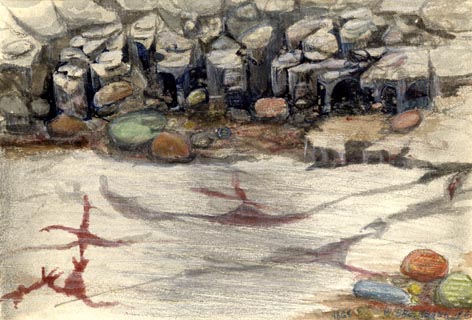 click to enlarge click to enlargePR1906.jpg "1868 W. BROCKBANK F.G.S" "ALDBY QUARRY - CLEATOR MOOR / CARBONIFEROUS LIMESTONE" "Glaciated Surface in Aldby Quarry / near Whitehaven / Wm. Brockbank F.G.S / Nov. 186[ ]" "Vein of Hematite Iron Ore" "Surface of Limestone planed smooth, with deep groovings and striations by Ice - the scratches S to N." "Drift Boulders - Granite, Greenstone, Porphyry, Clay Slate, Gossan, &c." "Surface of the Limestone after removing from 5 to 8ft of Till. Much waterworn." item:- Armitt Library : 1959.68.1 Image © see bottom of page |
|
|
|
||
 Lakes Guides menu.