 Old Cumbria Gazetteer
 |
 |
|
| included in:- |
 Carlisle Carlisle |
|
| Carlisle: Ogilby 1675 | ||
| evidence:- | old road book:- Ogilby 1675 (edn 1698) placename:- Carlisle placename:- Luguvallum placename:- Caerluel placename:- Caerleil |
|
| source data:- | OB16p019.txt page 19; plate 38 continued "... At 298'3 appears Carlton-V. of 3 F. and at 299'6 Boteherby vulgo Burraby of 2 F. at the End of which crossing, Petterel flv. at 300'7 at the English-Gate enter the City of CARLISLE." "A place of great Antiquity, Eminent under the Romans, and call'd in the Itinerary Tables Luguvallum; interpreted the Tower by the Vallum, i.e. the Picts Wall, near which it stands; whence contractedly Caer-luel and Carleil or Carlisle: 'Twas encompass'd with a Wall, about A.C.680 by Egfred K. of the Northumbers, and Fortify'd with a Castle by K. W. Rufus: Made an Episc. See by Hen. I Anno 1133. And dignify'd with the Title of an Earldom, belonging to the Noble Family of the Howards. 'Tis seated on the S. of Eden flv. and between the Petterel and the Caud on the E. and W. and lies Triangular, the Castle standing in the N-W. Corner, the Cathedral is a fine Structure, and the Houses well-built: 'Tis govern'd by a Mayor, 12 Aldermen, 2 Bailiffs, &c. sends Burgesses to Parl; Trades chiefly in Fustians, and keeps a considerable Mt. on Saturdays having 3 Gates, viz. the Caldo or Irish-Gate, Bother or English-Gate, and Rickard or Scotch-Gate." item:- private collection : 367 Image © see bottom of page |
|
|
|
||
| evidence:- | old map:- Ogilby 1675 (plate 38) placename:- Carlisle |
|
| source data:- | Road strip map, hand coloured engraving, continuation of the
Road from London to Carlisle, scale about 1 inch to 1 mile, by
John Ogilby, London, 1675.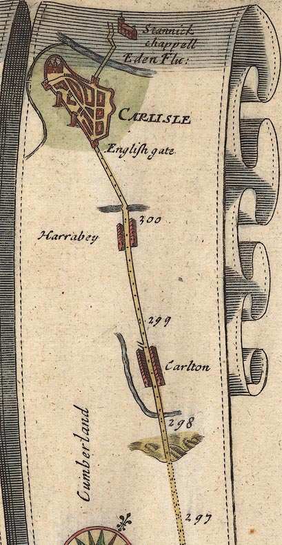 OG38m297.jpg In mile 301, Cumberland. "CARLISLE" town plan, town wall with bastions and town gates, castle, and cathedral. item:- JandMN : 21 Image © see bottom of page |
|
|
|
||
| evidence:- | old map:- Ogilby 1675 (plate 62) placename:- Carlisle |
|
| source data:- | Raod strip map, uncoloured engraving, the Road from Carlisle to
Barwick, scale about 1 inch to 1 mile, by John Ogilby, London,
1675.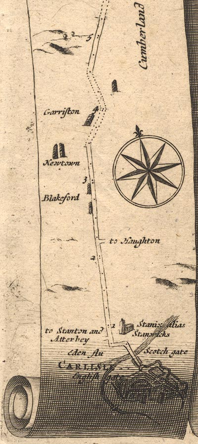 OG62m000.jpg In mile 0, Cumberland. "CARLISLE" town plan with town walls, bastions, and town gates. item:- JandMN : 83 Image © see bottom of page |
|
|
|
||
| evidence:- | old map:- Ogilby 1675 (plate 86) placename:- Carlisle |
|
| source data:- | Road strip map, uncoloured engraving, the Road from Tinmouth ...
to Carlisle, scale about 1 inch to 1 mile, by John Ogilby,
London, 1675.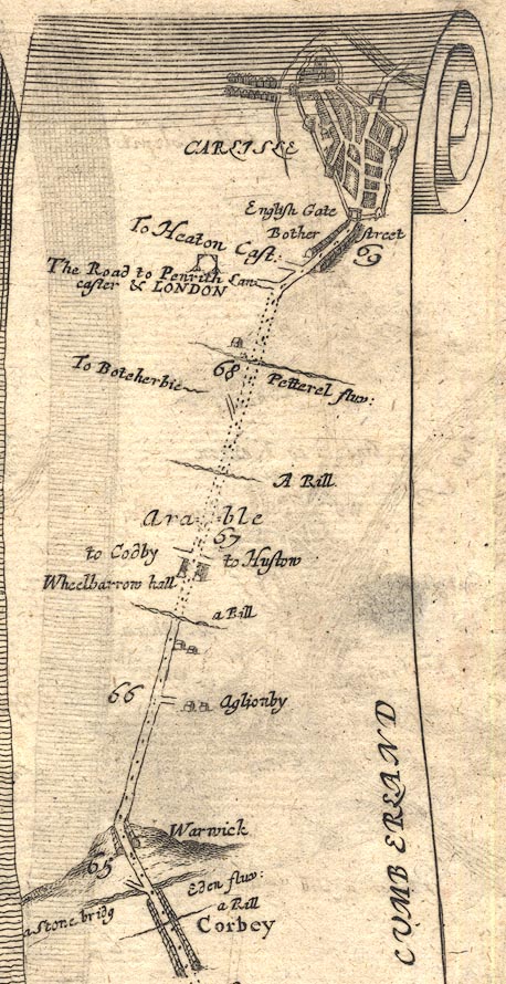 OG86m065.jpg In mile 69, Cumberland. "CARLISLE" town plan, town wall with bastions and town gates, castle, perhaps the cathedral, and suburbs; the orientation of the town plan roughly has north west at the top, which does not agree with the compass rose on the strip map. item:- JandMN : 73 Image © see bottom of page |
|
| source data:- | Road strip map, uncoloured engraving, the Road from Tinmouth ...
to Carlisle, scale about 1 inch to 1 mile, by John Ogilby,
London, 1675.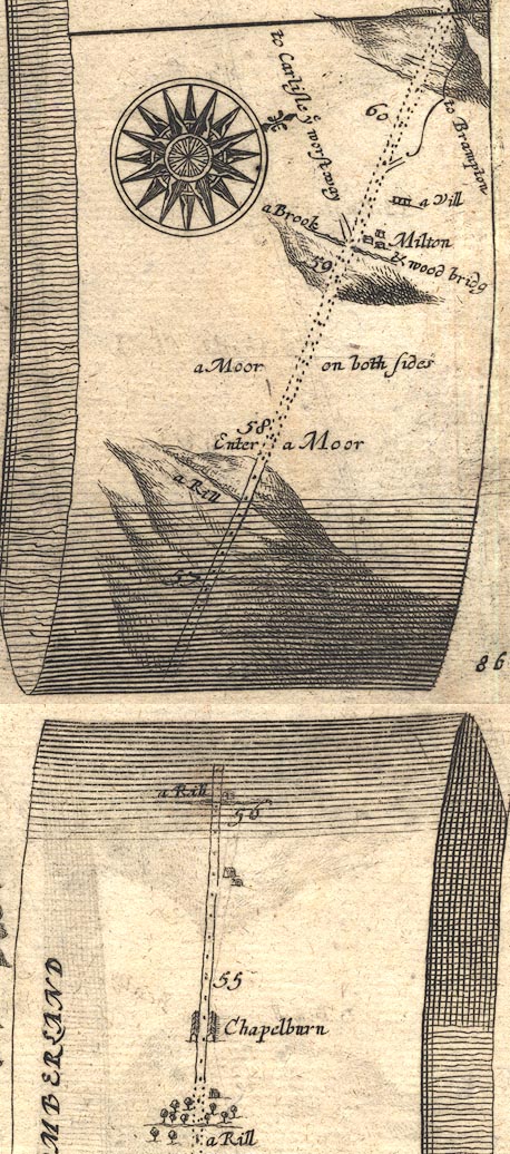 OG86m055.jpg In mile 59, Cumberland. Turning left:- "to Carlisle ye worst way" item:- JandMN : 73 Image © see bottom of page |
|
|
|
||
| evidence:- | old map:- Ogilby 1675 (plate 96) placename:- Carlisle |
|
| source data:- | Road strip map, hand coloured engraving, the Road from Kendal to
Cockermouth, and the Road from Egremond to Carlisle, scale about
1 inch to 1 mile, by John Ogilby, London, 1675.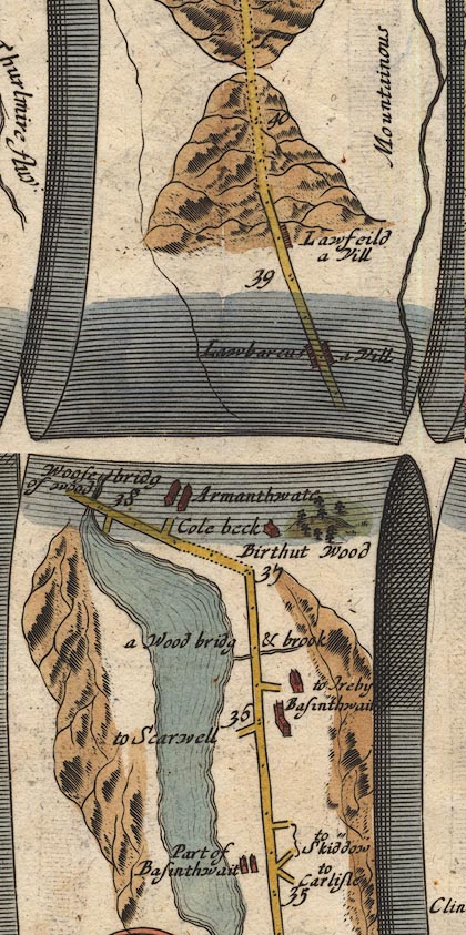 OG96m035.jpg In mile 35, Cumberland. Turning right:- "to Carlisle" In mile 39, Cumberland. "CARLISLE" town plan, town walls with bastions and town gates, rivers on two sides, suburbs. item:- JandMN : 22 Image © see bottom of page |
|
|
|
||
Lakes Guides menu.