 Old Cumbria Gazetteer
 |
 |
|
| included in:- |
 Stockdale, Longsleddale Stockdale, Longsleddale |
|
| Stockdale, Longsleddale: Corn Rent Act 1836 | ||
| evidence:- | tithe schedule:- Kendal Corn Rent Act 1836 placename:- Stockdale placename:- Little London |
|
| source data:- | Tithe map, Plan of part of the Township of Longsleddale, Westmorland, made regarding
the Kendal Corn Rent Act, ie a tithe award map, scale about 20 inches to 1 mile, Kendal,
Westmorland, 1836. Schedule, each row gives:- Field no. / Tenant's name / Close ie Field name / Type of culture / Area, acres Owned by James Anson, tenanted by James Cragg; Stockdale. "/ / Anson James" "/ 425a / James Cragg / Far Intake / Pas / 3 965" "/ 458 / Do / Nanny Close / Pas / 5 760" "/ 459 / Do / Gile Parrock / Ar &Waste / 0.780" "/ 461 / Do / Brock Cragg / Pas / 2 960" "/ 462 / 20/25 pts Do 10 Gaits / Stockdale Bank / Pas / 51 570" "/ 463 / 6/12 or ½Do 6 Gaits / Middleton Bank / Pas / 28 280" "/ 464 / [ /12 or / ] Do / Intake / Ar / 1 055" "/ 465 / Do / Intake / Ar / 3 485" "/ 466 / 6/12 or ½Do / Drift Road / Pas / 0 265" "/ 469 / Do / High Hale Intake / Pas / 2 100" "/ 470 / Do / Sheep Folds / Pas / 0 250" "/ 471 / Do / Hale Intake / Pas / 1 490" "/ 472 / Do / Little Carr / Pas / 0 470" "/ 473 / Do / Barn, fold &c / / 0 160" "/ 474 / Do / Barn &Plantation / / 0 090" "/ 475 / Do / Fold Yard / / 0 080" "/ 477 / Do / Homestead &c at Stockdale / / 0 170" "/ 478 / Do / Orchard / / 0 090" "/ 480 / Do / Langriggs / Mea / 2 250" "/ 481 / Do / Bracken How / Mea / 4 430" "/ 483 / Do / Horse Close / Mea / 0 915" "/ 485 / Do / Apple Tree Hole / Pas / 4 475" "/ 486 / Do / Kit Ing / Mea / 3 470" "/ 489 / Do / Trinket / Ar &Mea / 1 150" "/ 490 / Do / Broad Bit / Mea / 2 295" "/ 491 / Do / ----- / Mea / 2 040" "/ 492 / Do / Kiln How / Pas / 3 200" "/ 493 / Do / Plantation / / 0 130" "/ 494 / Do / Ellen Parrock / Pas / 0 340" "/ 495 / Do / Long Dale / Ar &Mea / 4 755" "/ 496 / Do / Yackers / Mea / 6 380" "/ 497 / Do / Beck Side / Mea / 0 060" "/ 504 / Do / Round Acre / Mea / 2 565" "/ 511 / Do / Low Halfacre / Mea / 0 900" "/ 512 / Do / Cruik / Ar &Mea / 1 045" "/ / / / / [total] 143 420" Owned by John Anson, tenanted by himself; Stockdale. "/ 456 / Himself / Mark Close / Mea / 2 875" "/ 457 / Do / Plantation / / 0 315" "/ 468 / Do / Back Side / / 0 255" "/ 476 / Do / House & Garden &c at Stockdale / / 0 170" "/ / / / / [total] 3 615" Owned by Thomas Hoggarth, tenanted by George Hoggarth; Stockdale. "/ / Hoggarth Thos." "/ 460 / George Hoggarth / Gile parrock / Pas / 0 655" "/ 462 / 1/25 pt. Do or ½gait / Stockdale Bank / pas/ 2 580" "/ 463 / 3/12 or Do 3 Gaits in / Middleton Bank / Pas / 14 140" "/ 466 / 3/12 Do / Drift Road / Pas / 0 130" "/ 467 / Do / Intake / Mea / 1 800" "/ 478a / Do / Homstd. &c at Stockdale / / 0 080" "/ 479 / Do / Carr / Pas / 0 830" "/ 482 / Do / Bracken Bed / Mea / 0 455" "/ 484 / Do / Blue Borrans / Ar &Mea / 4 180" "/ 487 / Do / Fleets Bank / Mea / 1 395" "/ 488 / Do / Trinket / Ar &Mea / 2 080" "/ / / / / [total] 28 295" "" 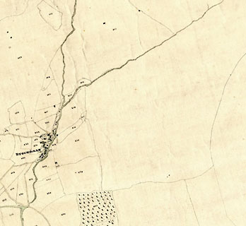 click to enlarge click to enlargeCRny4905.jpg map courtesy of Mark Cropper item:- private collection : 370 Image © see bottom of page |
|
|
|
||
| evidence:- | in part tithe schedule:- Kendal Corn Rent Act 1836 placename:- Stockdale |
|
| source data:- | Plan of the Township of Longsleddale, made for the Kendal Corn Rent Act, ie a tithe
award map, scale about 10 inches to 1 mile, Kendal, Westmorland, 1836. Schedule, each row gives:- Field no. / Tenant's name / Close ie Field name / Type of culture / Area, acres Owned by John Anson, tenanted by himself; Sad Gill. "/ / Anson John" "/ 405a / Himself ½ / Green Road &c / Pas. / 0 140" "/ 426 / Do / Hote Green / Ar &Mea / 1 220" "/ 427 / Do / Newlands / Pas / 2 140" "/ 428 / Do / Ing / Mea / 2 740" "/ 429 / Do / [Muglands] / Ar &Mea / 2 535" "/ 430 / Do / Rough Craggs / Pas / 89 780" "/ 431 / Do / Bank / Pas / 24 100" "/ 432 / Do / Bank Foot / Pas / 5 825" "/ 433 / Do / Wood / Pas &Wood / 7 515" "/ 434 / Do / Sheep Folds / / 0 060" "/ 435 / Do / High Parrock / Pas / 0 815" "/ 436 / Do / Low Do / Pas / 0 655" "/ 437 / Do / Homestead Lane &c at Sad Gill / Mea / 0 265" "/ 438 / Do / Brackenny brow / Mea / 3 895" "/ 439 / Do / Copse How / Mea / 4 055" "/ 440 / Do / Bonfire / Ar &Mea / 4 590" "/ 441 / Do / Hoghouse Close top / Mea / 1 650" "/ 442 / Do / Broad field / Mea / 3 135" "/ 443 / Do / Goose Mire / Mea / 1 080" "/ 445 / Do / Carr / Mea / 0 945" "/ 446 / Do / House &Garden at Stockdale / / 0 120" "/ 447 / Do / Parrock / Mea / 0 165" "/ 448 / Do / Pant / Mea / 0 565" "/ 462 / 4/25 Do or 2 Gaits / Stockdale Bank / Pas / 10 315" "/ 463 / 1/12 Do 1 Gait / Middleton Bank / Pas / 4 710" "/ 466 / 1/12 / Drift Road / Pas / 0 045" "/ / / / / [total] 174 275" |
|
|
|
||
Lakes Guides menu.