 Old Cumbria Gazetteer
 |
 |
|
| included in:- |
 Tills Hole, Longsleddale Tills Hole, Longsleddale |
|
| Tills Hole, Longsleddale: Corn Rent Act 1836 | ||
| evidence:- | tithe schedule:- Kendal Corn Rent Act 1836 placename:- Tills Hole |
|
| source data:- | Tithe map, Plan of part of the Township of Longsleddale, Westmorland, made regarding
the Kendal Corn Rent Act, ie a tithe award map, scale about 20 inches to 1 mile, Kendal,
Westmorland, 1836. Schedule, each row gives:- Field no. / Tenant's name / Close ie Field name / Type of culture / Area, acres Owned by Thomas Hudson snr, tenanted by himself; Tills Hole. "/ / Hudson Thos. Senior" "/ 345 / Himself 6/28 Gaits on / Cockley Fell / Pas / 56 780" "/ 373 / Do / Lane &c / / 0 320" "/ 374 / Do / Intake / Ar &Pas / 5 370" "/ 375 / Do / Near Field / Ar / 2 610" "/ 376 / Do / High Grassing / Pas / 22 475" "/ 377 / Do / Low Do / Pas / 10 840" "/ 378 / Do / Homstd &c at Tills Hole / / 0 210" "/ 379 / Do / Calf Parrock / Pas / 0 860" "/ 380 / Do / Croft / Ar &Mea / 3 975" "/ 381 / Do / Little Croft / Mea / 1 810" "/ 382 / Do / Grubbing / Mea / 0 900" "/ 383 / Do / Kit Ing / Mea / 1 415" "/ 384 / Do / Field Head / Ar &Mea / 5 310" "/ 385 / Do / Intake / Mea / 1 550" "/ 386 / Do / Whirl How / Mea / 1 240" "/ 387 / Do / House &Gar at / / 0 125" "/ 388 / Do / Do Stockdale / / 0 085" "/ 389 / Do / Barn at Do / / 0 020" "/ 463 / 2/12 Do 2 Gaits / Middleton Bank / Pas / 9 430" "/ 466 / 2/12 Do / Drift Road / Pas / 0 090" "/ / / / / [total] 125 415" "" 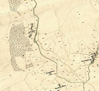 click to enlarge click to enlargeCRny4805.jpg map courtesy of Mark Cropper item:- private collection : 370 Image © see bottom of page |
|
|
|
||
| evidence:- | tithe awards:- Kendal Corn Rent Act 1836 placename:- Tills Hole |
|
| source data:- | Plan of the Township of Longsleddale, made for the Kendal Corn Rent Act, ie a tithe
award map, scale about 10 inches to 1 mile, Kendal, Westmorland, 1836. "Hudson Thomas Senr. / Himself / Tills Hole / 125 415 125 1 26 / ..." |
|
|
|
||
Lakes Guides menu.