 Old Cumbria Gazetteer
 |
 |
|
| Arnside Tower, Arnside | ||
| Arnside Tower | ||
| civil parish:- | Arnside (formerly Westmorland) | |
| county:- | Cumbria | |
| locality type:- | castle | |
| locality type:- | pele tower | |
| coordinates:- | SD45887683 | |
| 1Km square:- | SD4576 | |
| 10Km square:- | SD47 | |
|
|
||
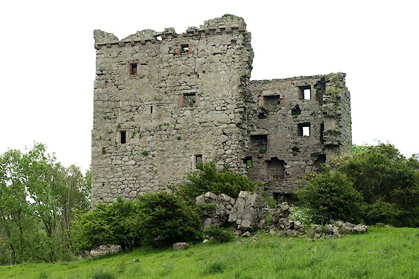 BQS71.jpg (taken 5.6.2009) 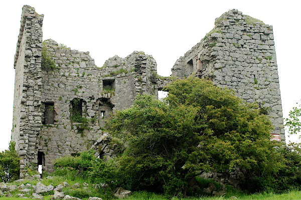 BQS72.jpg (taken 5.6.2009) |
||
|
|
||
| evidence:- | old map:- OS County Series (Wmd 46 14) placename:- Arnside Tower |
|
| source data:- | Maps, County Series maps of Great Britain, scales 6 and 25
inches to 1 mile, published by the Ordnance Survey, Southampton,
Hampshire, from about 1863 to 1948. " |
|
|
|
||
| evidence:- | old map:- Saxton 1579 placename:- Arneside Toure |
|
| source data:- | Map, hand coloured engraving, Westmorlandiae et Cumberlandiae Comitatus ie Westmorland
and Cumberland, scale about 5 miles to 1 inch, by Christopher Saxton, London, engraved
by Augustinus Ryther, 1576, published 1579-1645.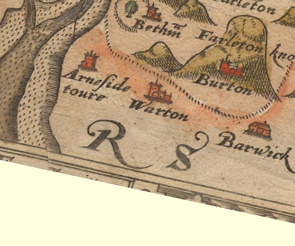 Sax9SD47.jpg Tower, symbol for a house, hall, tower, etc. "Arneside toure" Tower? settlement. item:- private collection : 2 Image © see bottom of page |
|
|
|
||
| evidence:- | old map:- Mercator 1595 (edn?) placename:- Arneside Tower |
|
| source data:- | Map, hand coloured engraving, Westmorlandia, Lancastria, Cestria
etc, ie Westmorland, Lancashire, Cheshire etc, scale about 10.5
miles to 1 inch, by Gerard Mercator, Duisberg, Germany, 1595,
edition 1613-16. MER5WmdA.jpg "Arneside towr." circle item:- Armitt Library : 2008.14.3 Image © see bottom of page |
|
|
|
||
| evidence:- | old map:- Speed 1611 (Wmd) placename:- Arneside Tower |
|
| source data:- | Map, hand coloured engraving, The Countie Westmorland and
Kendale the Cheif Towne, scale about 2.5 miles to 1 inch, by
John Speed, 1610, published by George Humble, Popes Head Alley,
London, 1611-12.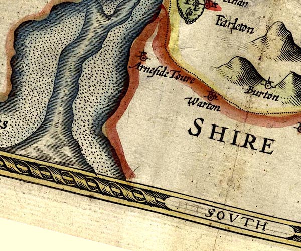 SP14SD47.jpg "Arneside Tower" circle, tower item:- Armitt Library : 2008.14.5 Image © see bottom of page |
|
|
|
||
| evidence:- | old map:- Jansson 1646 placename:- Arneside Toure |
|
| source data:- | Map, hand coloured engraving, Cumbria and Westmoria, ie
Cumberland and Westmorland, scale about 3.5 miles to 1 inch, by
John Jansson, Amsterdam, Netherlands, 1646.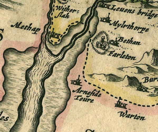 JAN3SD47.jpg "Arneside Toure" Buildings and tower. item:- JandMN : 88 Image © see bottom of page |
|
|
|
||
| evidence:- | old map:- Morden 1695 (Wmd) placename:- Armside Toure |
|
| source data:- | Map, hand coloured engraving, Westmorland, scale about 2.5 miles to 1 inch, by Robert
Morden, published by Abel Swale, the Unicorn, St Paul's Churchyard, Awnsham, and John
Churchill, the Black Swan, Paternoster Row, London, 1695.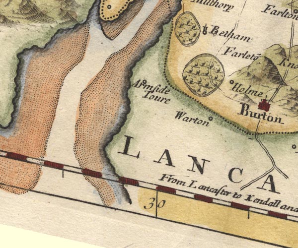 MD10SD47.jpg "Armside Toure" Circle. item:- JandMN : 24 Image © see bottom of page |
|
|
|
||
| evidence:- | old map:- Jefferys 1770 (Wmd) placename:- Arnside Tower |
|
| source data:- | Map, 4 sheets, The County of Westmoreland, scale 1 inch to 1
mile, surveyed 1768, and engraved and published by Thomas
Jefferys, London, 1770. J5SD47NE.jpg "Arnside Tower" tower item:- National Library of Scotland : EME.s.47 Image © National Library of Scotland |
|
|
|
||
| evidence:- | old map:- West 1784 map placename:- Arnside Tower |
|
| source data:- | Map, hand coloured engraving, A Map of the Lakes in Cumberland,
Westmorland and Lancashire, scale about 3.5 miles to 1 inch,
engraved by Paas, 53 Holborn, London, about 1784.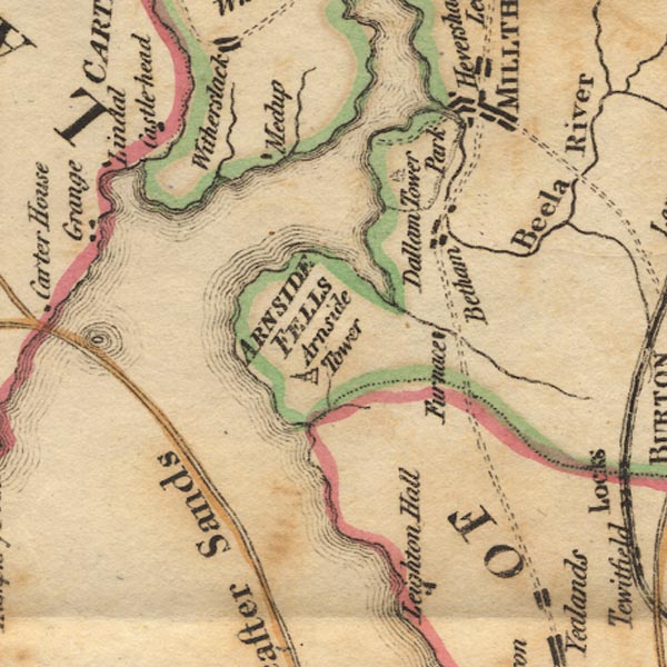 Ws02SD47.jpg Marked by a drawing of a tower. item:- Armitt Library : A1221.1 Image © see bottom of page |
|
|
|
||
| evidence:- | old text:- Camden 1789 (Gough Additions) placename:- Arnside Tower |
|
| source data:- | Book, Britannia, or A Chorographical Description of the Flourishing Kingdoms of England,
Scotland, and Ireland, by William Camden, 1586, translated from the 1607 Latin edition
by Richard Gough, published London, 1789. goto source goto sourcePage 153:- "..." "... Arnside tower, the walls thereof not yet much decayed. [Hazelslack and this] towers seem to have been erected to guard the bay; as there are on the opposite side the vestiges of Broughton tower and Bazin tower, so there is Castle head upon the island in Lindal Pow, and higher up the moses of Methop, Ulva, and Foulsham were inaccessible. In the centre of the bay is Peel castle." |
|
|
|
||
| evidence:- | old map:- Cary 1789 (edn 1805) |
|
| source data:- | Map, uncoloured engraving, Westmoreland, scale about 2.5 miles
to 1 inch, by John Cary, London, 1789; edition 1805.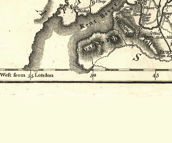 CY24SD47.jpg tower symbol item:- JandMN : 129 Image © see bottom of page |
|
|
|
||
| evidence:- | descriptive text:- Ford 1839 (3rd edn 1843) placename:- Arnside Tower |
|
| source data:- | Guide book, A Description of Scenery in the Lake District, by
Rev William Ford, published by Charles Thurnam, Carlisle, by W
Edwards, 12 Ave Maria Lane, Charles Tilt, Fleet Street, William
Smith, 113 Fleet Street, London, by Currie and Bowman,
Newcastle, by Bancks and Co, Manchester, by Oliver and Boyd,
Edinburgh, and by Sinclair, Dumfries, 1839. goto source Page 152:- "..." "... The ruins of Hilslack and Arnside towers are not very distant; they seem to have been erected to guard the Bay of Morecambe. ..." |
|
|
|
||
| evidence:- | old map:- Ford 1839 map placename:- Arnside Tower |
|
| source data:- | Map, uncoloured engraving, Map of the Lake District of
Cumberland, Westmoreland and Lancashire, scale about 3.5 miles
to 1 inch, published by Charles Thurnam, Carlisle, and by R
Groombridge, 5 Paternoster Row, London, 3rd edn 1843.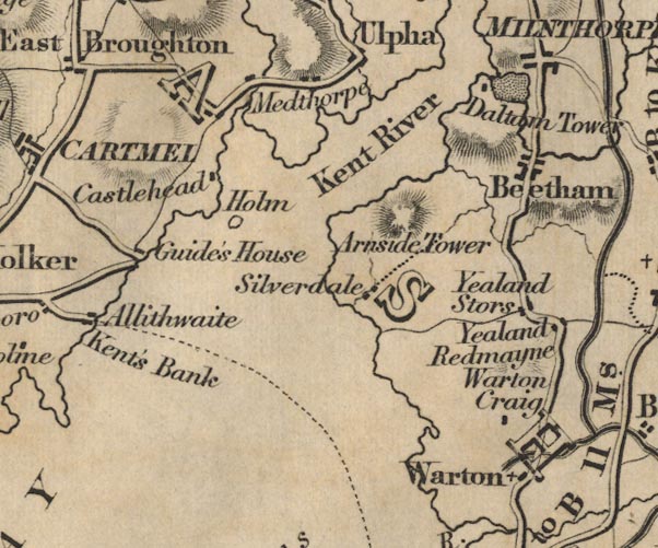 FD02SD47.jpg "Arnside Tower" item:- JandMN : 100.1 Image © see bottom of page |
|
|
|
||
| evidence:- | old drawing:- Aspland 1840s-60s placename:- Arnside Tower |
|
| source data:- | Drawing, pencil, Arnside Tower, Arnside, Lancashire, by Theophilus Lindsey Aspland,
22 May 1868.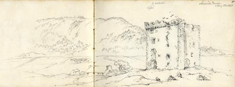 click to enlarge click to enlargeAS0606.jpg "Arnside Tower / May 22, 1868" page number "5" item:- Armitt Library : 2008.61.6 Image © see bottom of page |
|
|
|
||
| evidence:- | old photograph:- Bell 1880s-1940s placename:- Arnside Tower |
|
| source data:- | Photograph, Arnside Tower, Arnside, Westmorland, by Herbert Bell, photographer, Ambleside,
Westmorland, 1894.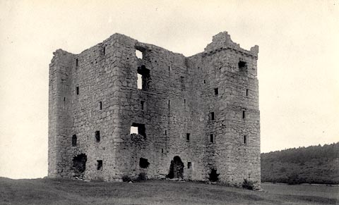 click to enlarge click to enlargeHB0107.jpg Vol.2 no.107 in an album, Examples of Early Domestic and Military Architecture in Westmorland, assembled 1910. ms at bottom:- "107. Arnside Tower Beetham. K." item:- Armitt Library : 1958.3166.1 Image © see bottom of page |
|
|
|
||
| evidence:- | old photograph:- Bell 1880s-1940s placename:- Arnside Tower |
|
| source data:- | Photograph, Arnside Tower, Arnside, Westmorland, by Herbert Bell, photographer, Ambleside,
Westmorland, 1894.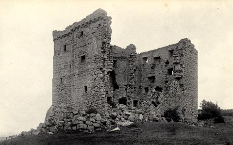 click to enlarge click to enlargeHB0108.jpg Vol.2 no.108 in an album, Examples of Early Domestic and Military Architecture in Westmorland, assembled 1910. ms at bottom:- "108. Arnside Tower Beetham. K." item:- Armitt Library : 1958.3166.2 Image © see bottom of page |
|
|
|
||
| evidence:- | old print:- Taylor 1892 placename:- Arnside Tower |
|
| source data:- | Print, plans of Arnside Tower, Arnside and Hazelslack Tower, Beetham, Westmorland,
published for the Cumberland and Westmorland Antiquarian and Archaeological Society,
by Titus Wilson, Kendal, Westmorland, and by Charles Thurnam and Sons, Carlisle, Cumberland,
1892.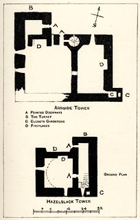 click to enlarge click to enlargeTY5044.jpg Tipped in opposite p.216 of The Old Manorial Halls of Cumberland and Westmorland, by Michael Waistell Taylor. item:- Armitt Library : A785.44 Image © see bottom of page |
|
|
|
||
| evidence:- | old print:- Taylor 1892 placename:- Arnside Tower |
|
| source data:- | Print, halftone photograph, Arnside Tower, Arnside, Westmorland, published for the
Cumberland and Westmorland Antiquarian and Archaeological Society, by Titus Wilson,
Kendal, Westmorland, and by Charles Thurnam and Sons, Carlisle, Cumberland, 1892.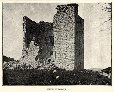 click to enlarge click to enlargeTY5045.jpg Tipped in opposite p.217 of The Old Manorial Halls of Cumberland and Westmorland, by Michael Waistell Taylor. item:- Armitt Library : A785.45 Image © see bottom of page |
|
|
|
||
| evidence:- | site plan:- Historical Monuments 1936 placename:- Arnside Tower |
|
| source data:- | Site plan, uncoloured lithograph, Arnside Tower, Arnside, Westmorland, scale about
1 to 290, published by Royal Commission on Historical Monuments England, London, 1936.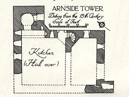 click to enlarge click to enlargeHMW010.jpg On p.14 of the Inventory of the Historical Monuments in Westmorland. printed, upper right "ARNSIDE TOWER" RCHME no. Wmd, Arnside 1 item:- Armitt Library : A745.10 Image © see bottom of page |
|
|
|
||
| evidence:- | database:- Listed Buildings 2010 placename:- Arnside Tower |
|
| source data:- | courtesy of English Heritage "ARNSIDE TOWER / / / ARNSIDE / SOUTH LAKELAND / CUMBRIA / II[star] / 76544 / SD4587876837" |
|
| source data:- | courtesy of English Heritage "Fortified Tower House. Probably C15. Burnt 1602, repaired probably mid C17, dismantled late C17. Massive limestone rubble walls with roughly dressed stone details. Staircase tower of rectangular plan and projecting garderobe. Formerly 5 storeys. Window openings to all sides, some blocked or extended: surviving openings have square heads. Parapet, projecting on rounded corbels, survives to North-west corner. Interior has remains of cross-wall incorporating newel stair, fireplaces with stone lintels and a niche on the first floor said to have been used as a piscina which suggests that the East corner may have been a chapel. Although ruinous at time of survey it appears to be a unique example in this area of a freestanding tower built without a hall block. See RCHM pp 14-15 for further description and plan." |
|
|
|
||
 BQS70.jpg (taken 5.6.2009) |
||
|
|
||
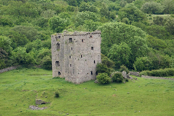
| hearsay:- |
Large, 48x33 feet, 5 storey pele tower, plus annexe. The hall was on the 3rd storey.
There is a vaulted oven in the basemanet. |
|
|
|
||
| notes:- |
14th century tower house |
|
| Perriam, D R &Robinson, J: 1998: Medieval Fortified Buildings of Cumbria: CWAAS::
ISBN 1 873124 23 6; plan and illustration |
||
|
|
||
Lakes Guides menu.