 Old Cumbria Gazetteer
 |
 |
|
| Braithwaite Fold, Windermere | ||
| Braithwaite Fold | ||
| locality:- | Bowness-on-Windermere | |
| civil parish:- | Windermere (formerly Westmorland) | |
| county:- | Cumbria | |
| locality type:- | buildings | |
| coordinates:- | SD40049567 | |
| 1Km square:- | SD4095 | |
| 10Km square:- | SD49 | |
|
|
||
| evidence:- | old map:- OS County Series (Wmd 32 15) placename:- Braithwaite Fold |
|
| source data:- | Maps, County Series maps of Great Britain, scales 6 and 25
inches to 1 mile, published by the Ordnance Survey, Southampton,
Hampshire, from about 1863 to 1948. |
|
|
|
||
| evidence:- | old map:- Jefferys 1770 (Wmd) placename:- Braythwaite Fould |
|
| source data:- | Map, 4 sheets, The County of Westmoreland, scale 1 inch to 1
mile, surveyed 1768, and engraved and published by Thomas
Jefferys, London, 1770.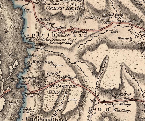 J5SD49NW.jpg "Braythwaite Fould" circle, labelled in italic lowercase text; settlement, farm, house, or hamlet? item:- National Library of Scotland : EME.s.47 Image © National Library of Scotland |
|
|
|
||
| evidence:- | old map:- Crosthwaite 1783-94 (Win/Ble) placename:- Brathwaite Fold |
|
| source data:- | Map, uncoloured engraving, An Accurate Map of the Grand Lake of
Windermere, scale about 2 inches to 1 mile, by Peter
Crosthwaite, Keswick, Cumberland, 1783, version published 1819.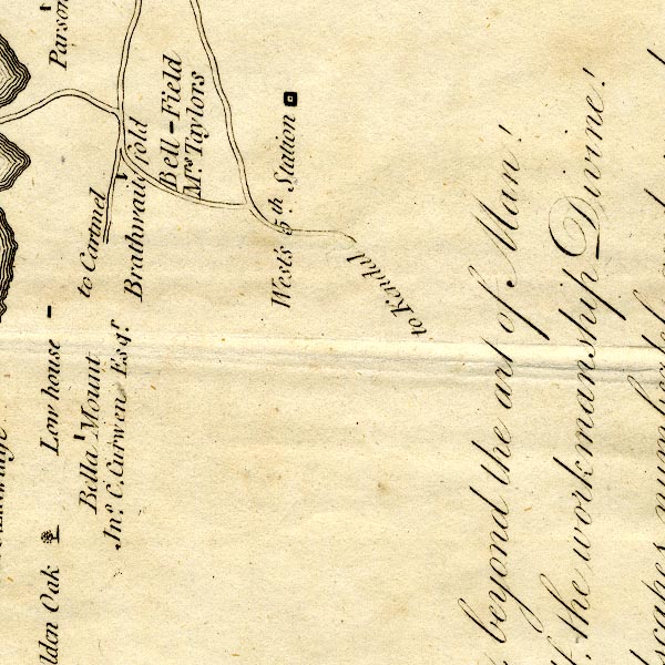 CT9SD49C.jpg "Brathwaite fold" block, building/s item:- Armitt Library : 2008.14.102 Image © see bottom of page |
|
|
|
||
| evidence:- | old map:- Clarke 1787 map (Windermere S) placename:- Brathwaite Fold |
|
| source data:- | Map, A Map of the Southern Part of the Lake Winandermere and its
Environs, scale about 6.5 ins to 1 mile, by James Clarke,
engraved by Samuel John Neele, 352 Strand, published by James
Clarke, Penrith, Cumberland and in London etc, 1787. CLBSD49C.jpg "Brathwaite / Fold" item:- private collection : 10.11 Image © see bottom of page |
|
|
|
||
| evidence:- | old map:- Cary 1789 (edn 1805) placename:- Brathwaite Fauld |
|
| source data:- | Map, uncoloured engraving, Westmoreland, scale about 2.5 miles
to 1 inch, by John Cary, London, 1789; edition 1805. CY24SD49.jpg "Brathwaite Fauld" block/s, labelled in italic lowercase; house, or hamlet item:- JandMN : 129 Image © see bottom of page |
|
|
|
||
| evidence:- | old map:- Prior 1874 map 1 placename:- Braithwaite Fold |
|
| source data:- | Map, uncoloured engraving or lithograph? Winander Mere, scale
about 2.5 miles to 1 inch, published by John Garnett,
Windermere, Westmorland, 1874.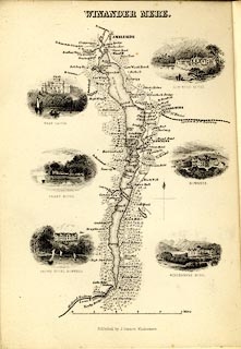 click to enlarge click to enlargePI03M1.jpg "Braithwaite Fold" block/s; building/s item:- private collection : 133.1 Image © see bottom of page |
|
|
|
||
| evidence:- | database:- Listed Buildings 2010 placename:- Braithwaite Fold item:- spinning gallery; gallery |
|
| source data:- | courtesy of English Heritage "BRAITHWAITE FOLD / / B 5284 / WINDERMERE TOWN / SOUTH LAKELAND / CUMBRIA / NG / 351718 / SD4005695670" |
|
|
|
||
 Lakes Guides menu.