 Old Cumbria Gazetteer
 |
 |
|
| Burnbank Fell, Loweswater | ||
| Burnbank Fell | ||
| civil parish:- | Loweswater (formerly Cumberland) | |
| county:- | Cumbria | |
| locality type:- | hill | |
| locality type:- | fell | |
| coordinates:- | NY11362128 (etc) | |
| 1Km square:- | NY1121 | |
| 10Km square:- | NY12 | |
| altitude:- | 1466 feet | |
| altitude:- | 447m | |
|
|
||
| evidence:- | old map:- OS County Series (Cmd 62 12) placename:- Burnbank Fell |
|
| source data:- | Maps, County Series maps of Great Britain, scales 6 and 25
inches to 1 mile, published by the Ordnance Survey, Southampton,
Hampshire, from about 1863 to 1948. |
|
|
|
||
| evidence:- | outline view:- Black 1856 placename:- Burn Bank |
|
| source data:- | Print, lithograph, Outline Views, Buttermere - Mountains as seen from the Knots near
the Hotel at Buttermere, and Mountains as seen at the Seat in Lanthwaite Wood, Scale
Hill, by J Flintoft, Keswick, Cumberland, engraved by R Mason, Edinburgh, Lothian,
about 1900.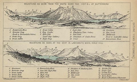 click to enlarge click to enlargeBC08E5.jpg "... 20 Burn Bank ..." item:- JandMN : 37.19 Image © see bottom of page |
|
|
|
||
| evidence:- | outline view:- Black 1841 (3rd edn 1846) placename:- Burn Bank |
|
| source data:- | Print, engraving, outline view, Mountains as seen from The Knots near the Victoria
at Buttermere, and Mountains as seen at the Seat in Lanthwaite Wood, Scale Hill, by
J Flintoft, Keswick, Cumberland, engraved by R Mason, Edinburgh, Lothian, about 1846.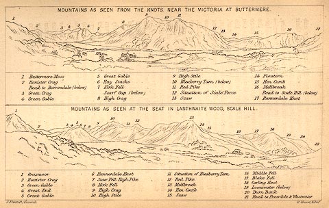 click to enlarge click to enlargeBC02E7.jpg "... 20 Burn Bank ..." item:- JandMN : 32.11 Image © see bottom of page |
|
|
|
||
 Lakes Guides menu.