 Old Cumbria Gazetteer
 |
 |
|
| Castlerigg Fell, St John's Castlerigg etc | ||
| Castlerigg Fell | ||
| civil parish:- | St John's Castlerigg and Wythburn (formerly Cumberland) | |
| county:- | Cumbria | |
| locality type:- | hill | |
| locality type:- | fell | |
| coordinates:- | NY28891945 (etc) | |
| 1Km square:- | NY2819 | |
| 10Km square:- | NY21 | |
|
|
||
| evidence:- | old map:- OS County Series (Cmd 64 15) placename:- Castlerigg Fell |
|
| source data:- | Maps, County Series maps of Great Britain, scales 6 and 25
inches to 1 mile, published by the Ordnance Survey, Southampton,
Hampshire, from about 1863 to 1948. |
|
|
|
||
| evidence:- | old map:- Ogilby 1675 (plate 96) |
|
| source data:- | Road strip map, hand coloured engraving, the Road from Kendal to
Cockermouth, and the Road from Egremond to Carlisle, scale about
1 inch to 1 mile, by John Ogilby, London, 1675.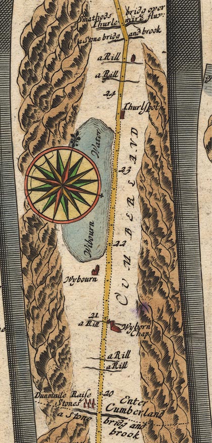 OG96m020.jpg In miles 20 to 27, Cumberland. Mountains on the left of the road for 7 miles. item:- JandMN : 22 Image © see bottom of page |
|
|
|
||
| evidence:- | old text:- Gents Mag item:- lightning; sheep |
|
| source data:- | Magazine, The Gentleman's Magazine or Monthly Intelligencer or
Historical Chronicle, published by Edward Cave under the
pseudonym Sylvanus Urban, and by other publishers, London,
monthly from 1731 to 1922. goto source goto sourceGentleman's Magazine 1806 p.576 "... Five sheep were killed on Castle-rig-fell, near Keswick. One of them had the wool stripped off one side, from the head to the tail. The electric matter had taken a circular direction, and turned up the soil as with a spade." |
|
|
|
||
| evidence:- | descriptive text:- Otley 1823 (5th edn 1834) item:- geology |
|
| source data:- | Guide book, A Concise Description of the English Lakes, the
mountains in their vicinity, and the roads by which they may be
visited, with remarks on the mineralogy and geology of the
district, by Jonathan Otley, published by the author, Keswick,
Cumberland now Cumbria, by J Richardson, London, and by Arthur
Foster, Kirkby Lonsdale, Cumbria, 1823; published 1823-49,
latterly as the Descriptive Guide to the English Lakes. goto source Page 156:- "... Garnets are found imbedded in some of the rocks on Castlerigg Fell and Great Gable. ..." "... An amygdaloid rock, containing nodules of calcareous spar, and sometimes of agate, opal or calcedony, is met with in several places; as ... Castlerigg Fell near Keswick ..." |
|
|
|
||
| evidence:- | old map:- Garnett 1850s-60s H placename:- Castlerigg |
|
| source data:- | Map of the English Lakes, in Cumberland, Westmorland and
Lancashire, scale about 3.5 miles to 1 inch, published by John
Garnett, Windermere, Westmorland, 1850s-60s.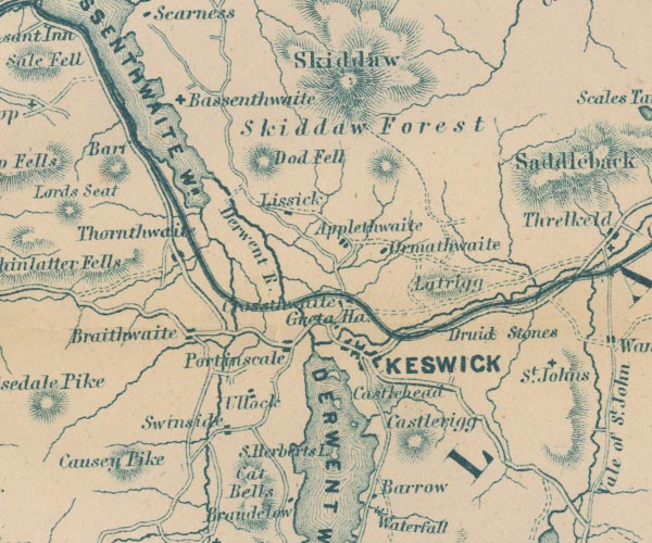 GAR2NY22.jpg "Castlerigg" hill hachuring item:- JandMN : 82.1 Image © see bottom of page |
|
|
|
||
| evidence:- | outline view:- Martineau 1855 placename:- Castlerigg |
|
| source data:- | Print, engraving, outline view, Mountains seen from the West Side of Thirlmere, drawn
by L Aspland, engraved by W Banks, Edinburgh, published by John Garnett, Windermere,
Westmorland, and by Whittaker and Co, London, 1855.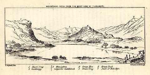 click to enlarge click to enlargeMNU110.jpg Plate opposite p.69 in A Complete Guide to the English Lakes, by Harriet Martineau. "MOUNTAINS SEEN FROM THE WEST SIDE OF THIRLMERE." "L Aspland Delt. / W Banks Sc Edinr." The view is captioned, numbers referring to mountains in the image:- "1 Raven Crag, 2 Castlerigg, 3 Blancathra vulgariter Saddleback, 4 Great How, 5 Green Crag, 6, Great Dod, 7 Part of Helvellyn." item:- Armitt Library : A1159.10 Image © see bottom of page |
|
|
|
||
Lakes Guides menu.