 Old Cumbria Gazetteer
 |
 |
|
| Clifton Hall, Clifton | ||
| Clifton Hall | ||
| Clifton Tower | ||
| locality:- | Clifton | |
| civil parish:- | Clifton (formerly Westmorland) | |
| county:- | Cumbria | |
| locality type:- | buildings | |
| coordinates:- | NY53072710 | |
| 1Km square:- | NY5327 | |
| 10Km square:- | NY52 | |
| SummaryText:- | Remaining tower of a 15th century manor. | |
|
|
||
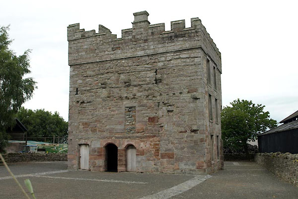 BUY54.jpg (taken 15.7.2011) 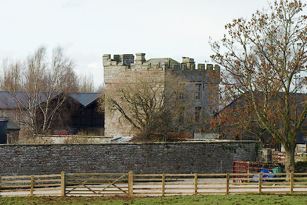 BQE96.jpg (taken 6.3.2009) |
||
|
|
||
| evidence:- | hearth tax returns:- Hearth Tax 1675 placename:- hall |
|
| source data:- | Records, hearth tax survey returns, Westmorland, 1674/75. "hall" in "Clifton" |
|
|
|
||
| evidence:- | old map:- Bowen and Kitchin 1760 placename:- Clifton Hall |
|
| source data:- | Map, hand coloured engraving, A New Map of the Counties of
Cumberland and Westmoreland Divided into their Respective Wards,
scale about 4 miles to 1 inch, by Emanuel Bowen and Thomas
Kitchin et al, published by T Bowles, Robert Sayer, and John
Bowles, London, 1760.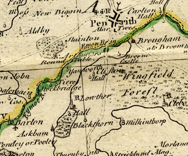 BO18NY42.jpg "[Clifton] Hall" circle and line item:- Armitt Library : 2008.14.10 Image © see bottom of page |
|
|
|
||
| evidence:- | old map:- Jefferys 1770 (Wmd) placename:- Hall |
|
| source data:- | Map, 4 sheets, The County of Westmoreland, scale 1 inch to 1
mile, surveyed 1768, and engraved and published by Thomas
Jefferys, London, 1770.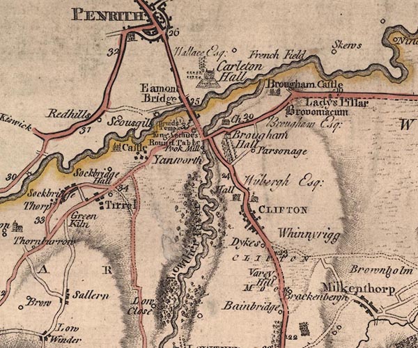 J5NY52NW.jpg "Hall / Wybergh Esq;" castle, at Clifton item:- National Library of Scotland : EME.s.47 Image © National Library of Scotland |
|
|
|
||
| evidence:- | old map:- Cary 1789 (edn 1805) |
|
| source data:- | Map, uncoloured engraving, Westmoreland, scale about 2.5 miles
to 1 inch, by John Cary, London, 1789; edition 1805.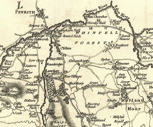 CY24NY52.jpg "Hall" house symbol; large house item:- JandMN : 129 Image © see bottom of page |
|
|
|
||
| evidence:- | old map:- Baker 1802 placename:- Clifton Hall |
|
| source data:- | Perspective road maps with sections in Lancashire, Westmorland
and Cumberland, by J Baker, London 1802.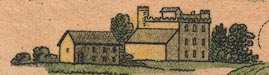 Bk03Vg07.jpg "Clifton Hall" item:- private collection : 3 Image © see bottom of page |
|
|
|
||
| evidence:- | descriptive text:- Ford 1839 (3rd edn 1843) |
|
| source data:- | Guide book, A Description of Scenery in the Lake District, by
Rev William Ford, published by Charles Thurnam, Carlisle, by W
Edwards, 12 Ave Maria Lane, Charles Tilt, Fleet Street, William
Smith, 113 Fleet Street, London, by Currie and Bowman,
Newcastle, by Bancks and Co, Manchester, by Oliver and Boyd,
Edinburgh, and by Sinclair, Dumfries, 1839. goto source goto sourcePage 134:- "further on, is Clifton: its old hall, now a farm-house, is a turreted building. ..." |
|
|
|
||
| evidence:- | old photograph:- Bell 1880s-1940s placename:- Clifton Hall |
|
| source data:- | Photograph, Clifton Hall, Clifton, Westmorland, by Herbert Bell, photographer, Ambleside,
Westmorland, 1896.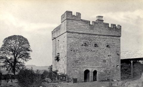 click to enlarge click to enlargeHB0093.jpg Vol.1 no.93 in an album, Examples of Early Domestic and Military Architecture in Westmorland, assembled 1910. ms at bottom:- "93. Clifton Hall. Clifton. W." item:- Armitt Library : 1958.3165.93 Image © see bottom of page |
|
|
|
||
| evidence:- | old print:- Taylor 1892 placename:- Clifton Hall item:- hayrick |
|
| source data:- | Print, Clifton Hall, Clifton, Westmorland, published for the Cumberland and Westmorland
Antiquarian and Archaeological Society, by Titus Wilson, Kendal, Westmorland, and
by Charles Thurnam and Sons, Carlisle, Cumberland, 1892. click to enlarge click to enlargeTY5009.jpg Tipped in opposite p.77 of The Old Manorial Halls of Cumberland and Westmorland, by Michael Waistell Taylor. item:- Armitt Library : A785.9 Image © see bottom of page |
|
|
|
||
| evidence:- | old print:- Taylor 1892 placename:- Clifton Hall |
|
| source data:- | Print, plans of Clifton Hall, Clifton, Westmorland, published for the Cumberland and
Westmorland Antiquarian and Archaeological Society, by Titus Wilson, Kendal, Westmorland,
and by Charles Thurnam and Sons, Carlisle, Cumberland, 1892.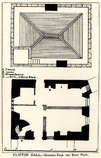 click to enlarge click to enlargeTY5010.jpg Tipped in opposite p.79 of The Old Manorial Halls of Cumberland and Westmorland, by Michael Waistell Taylor. item:- Armitt Library : A785.10 Image © see bottom of page |
|
|
|
||
| evidence:- | old text:- Harper 1907 |
|
| source data:- | Guidebook, The Manchester and Glasgow Road, by Charles G Harper,
published by Chapman and Hall Ltd, London, 1907. HP01p115.txt Page 115:- "..." "It is at Clifton, just south of Penrith, that the real Borderland begins. We are still thirty-five miles short of the actual border-line, but we have come now within the "sphere of influence" (as international politicians now phrase it) of the old moss-trooping, cattle-lifting, and plundering and burning rascals from the Scottish side, who ever and again came across the Solway in well-mounted bands that numbered perhaps twenty, or perhaps five hundred, and often swept the countryside clean of stock; returning as swiftly as they had come, and leaving burning homesteads behind them. Those times have left plentiful traces, still plain to see, in the old domestic architecture of mansion and farmstead. Castles we have here, as elsewhere, but this borderland is the country of the peel-tower. In ages when the south of England lived in security, and men no longer built homes that were half fortresses, these oft-raided northern counties still lived in constant and well-founded apprehensions, and every one who had anything to lose had his own stronghold, in the little peel-tower that was, according to circumstances, his entire home," HP01p116.txt Page 116:- "or a considerable part of it. Many of the peel-towers remain, as uninhabited ruins: others form the central portion of houses and mansions since enlarged. At Clifton stands such an one." "It is a fair type of the defences once absolutely necessary. You see the care taken to build strongly, with thick walls that no swiftly-moving band of raiders could have leisure to demolish; and you see, too, that it was equally impossible to burn. The ground floor was not only exceptionally solid, but it had no entrance from without, and was reached only by a trap-door in the floor above." "So soon as the farmer or the squireen of those days had taken alarm, he drove his stock into the barmkin, or enclosure, attached to his tower of refuge, and, summoning all his family and securing his valuables, ascended with them by a ladder to the first floor, and, withdrawing the ladder after him, awaited events. For defence he had a store of heavy stones on the leads above the second floor; or from the narrow-slitted windows could shift to shoot arrows, or fling hot water, boiling tar, or domestic sewage upon enemies who came near enough." "But the cattle were still in danger, and the men of the house were usually concerned to garrison the tower with the women and children, and to give fight, if the odds were not overwhelming, outside; and many a Westmoreland and Cumberland farmer has died in protecting his stock." |
|
|
|
||
| evidence:- | old print:- Curwen 1913 placename:- Clifton Hall |
|
| source data:- | Print, halftone photograph, Clifton Hall, Clifton, Westmorland, published for the
Cumberland and Westmorland Antiquarian and Archaeological Society by Titus Wilson,
Kendal, Westmorland, 1913.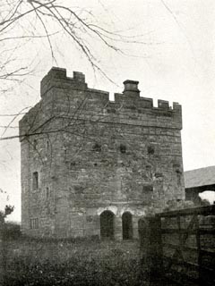 click to enlarge click to enlargeCW0174.jpg Tipped in opposite p.360 of The Castles and Fortified Towers of Cumberland, Westmorland, and Lancashire North of the Sands, by John F Curwen. printed at bottom:- "CLIFTON HALL." item:- Armitt Library : A782.74 Image © see bottom of page |
|
|
|
||
| evidence:- | descriptive text:- Burrow 1920s |
|
| source data:- | Road book, strip maps with parts in Westmorland, Cumberland etc,
irregular scales about 1.5 miles to 1 inch, by E J Burrow and
Co, Cheltenham, Gloucestershire, 1920s. "... At Clifton, ... is one of the peel towers which were considered an indispensable adjunct to any house of importance during the troublous times of Border raids. These peel towers were not parts of extensive castles but single towers to which the householder could withdraw his family for safety at the approach of danger. ..." |
|
|
|
||
| evidence:- | old map:- Burrow 1920s |
|
| source data:- | Road book, On the Road, Dunlop Pictorial Road Plans, volume V,
strip maps with parts in Westmorland, Cumberland etc, irregular
scale about 1.5 miles to 1 inch, by E J Burrow and Co,
Cheltenham, Gloucestershire, 1920s.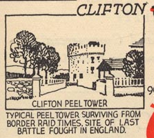 EJB3Vg19.jpg item:- private collection : 17 Image © see bottom of page |
|
|
|
||
| evidence:- | old print:- LMS 1920s |
|
| source data:- | Peel Tower at Clifton, drawn by R M Hutchings, published in the LMS Route Book No.3,
The Track of the Royal Scot, by the London, Midland and Scottish Railway, LMS, 1920s.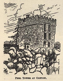 click to enlarge click to enlargeLS1E38.jpg item:- JandMN : 95.11 Image © see bottom of page |
|
|
|
||
| evidence:- | old print:- Bogg 1898 placename:- Clifton Peel Tower |
|
| source data:- | Print, engraving, Clifton Peel Tower, Clifton, Westmorland, by A Haselgrave, published
by Edmund Bogg, 3 Woodhouse Lane, and James Miles, Guildford Street, Leeds, Yorkshire,
1898.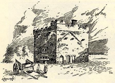 click to enlarge click to enlargeBGG135.jpg Included on p.130 of Lakeland and Ribblesdale, by Edmund Bogg. item:- JandMN : 231.35 Image © see bottom of page |
|
|
|
||
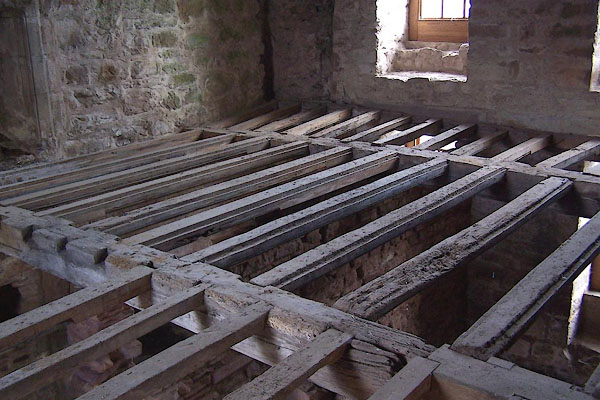 BLM02.jpg Floor beams and joists. (taken 23.12.2005) 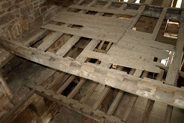 BUY56.jpg Floor beams and joists. (taken 15.7.2011) 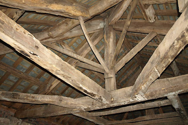 BUY55.jpg Roof beams, kingpost. (taken 15.7.2011) 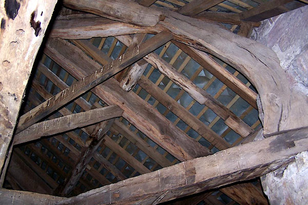 BLM03.jpg Roof beams. (taken 23.12.2005) 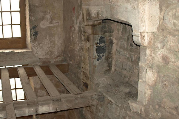 BUY57.jpg Fireplace. (taken 15.7.2011) 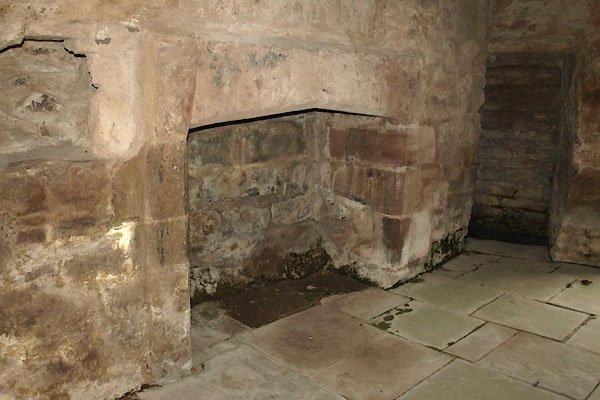 BUY58.jpg Fireplace. (taken 15.7.2011) 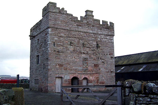 BLM01.jpg (taken 23.12.2005) |
||
|
|
||
| hearsay:- |
Pele of about 1500; other, earlier buildings gone. |
|
| Home of the Engayne Family, later the Wybergh Family. |
||
|
|
||
| notes:- |
tower and site of several halls |
|
| Perriam, D R &Robinson, J: 1998: Medieval Fortified Buildings of Cumbria: CWAAS::
ISBN 1 873124 23 6; plan and illustration |
||
|
|
||
| person:- | : English Heritage |
|
|
|
||
Lakes Guides menu.