 Old Cumbria Gazetteer
 |
 |
|
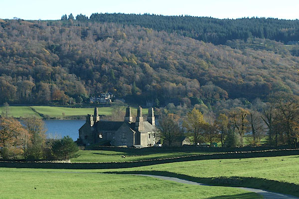
| Coniston Hall, Coniston | ||
| Coniston Hall | ||
| locality:- | Coniston | |
| civil parish:- | Coniston (formerly Lancashire) | |
| county:- | Cumbria | |
| locality type:- | buildings | |
| coordinates:- | SD30449634 | |
| 1Km square:- | SD3096 | |
| 10Km square:- | SD39 | |
|
|
||
 BTU21.jpg (taken 10.11.2010) 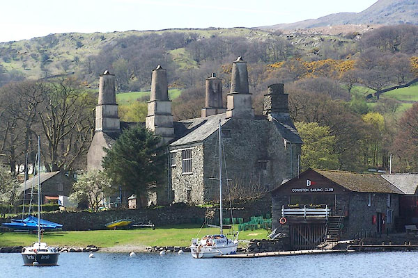 BLZ65.jpg (taken 28.4.2006) |
||
|
|
||
| evidence:- | old map:- OS County Series (Lan 4 8) placename:- Coniston Hall |
|
| source data:- | Maps, County Series maps of Great Britain, scales 6 and 25
inches to 1 mile, published by the Ordnance Survey, Southampton,
Hampshire, from about 1863 to 1948. |
|
|
|
||
| evidence:- | descriptive text:- West 1778 (11th edn 1821) |
|
| source data:- | Guide book, A Guide to the Lakes, by Thomas West, published by
William Pennington, Kendal, Cumbria once Westmorland, and in
London, 1778 to 1821. goto source goto sourcePage 51:- "... [from station, Coniston 2] On the western margin stands the lady of the lake, Coniston-hall, concealed in a grove of tall trees, and above it, the village of the same name. The hall has only changed masters twice since the conquest, and has belonged to the family of Fleming most of time." |
|
|
|
||
| evidence:- | old map:- Crosthwaite 1783-94 (Con) placename:- Coniston Park and Hall |
|
| source data:- | Map, uncoloured engraving, An Accurate Map of Coniston Lake,
scale about 3 inches to 1 mile, by Peter Crosthwaite, Keswick,
Cumberland, 1788, version published 1809.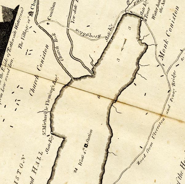 CTESD39D.jpg "CONISTON PARK and HALL / Sr. Michael le Fleming's Bart." area, and block for building/s item:- JandMN : 182.5 Image © see bottom of page |
|
|
|
||
| evidence:- | old map:- West 1784 map placename:- Coniston Hall |
|
| source data:- | Map, hand coloured engraving, A Map of the Lakes in Cumberland,
Westmorland and Lancashire, scale about 3.5 miles to 1 inch,
engraved by Paas, 53 Holborn, London, about 1784.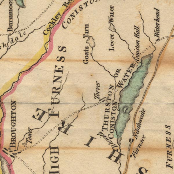 Ws02SD29.jpg item:- Armitt Library : A1221.1 Image © see bottom of page |
|
|
|
||
| evidence:- | old text:- Green 1810 placename:- Coniston Hall |
|
| source data:- | Set of prints, soft ground etchings, Sixty Studies from Nature,
by William Green, Ambleside, Westmorland, drawn 1808-10,
published 1810. goto source page 3:- "... about two miles from the head of the lake; Coniston Hall is here a good object, though probably half a mile distant, and will serve as a principal to the sprinkling of farm houses and cottages, which compose the village of Coniston. ... Coniston Hall is a picturesque old building; it is partly in ruins, and a considerable portion, not only of the ruined, but the habitable" goto sourcepage 4:- "parts, covered with ivy; trees have been suffered to remain near the hall, and they are in unison with it, being chiefly aged sycamores; n..." |
|
|
|
||
| evidence:- | old map:- Otley 1818 placename:- Hall |
|
| source data:- | Map, uncoloured engraving, The District of the Lakes,
Cumberland, Westmorland, and Lancashire, scale about 4 miles to
1 inch, by Jonathan Otley, 1818, engraved by J and G Menzies,
Edinburgh, Scotland, published by Jonathan Otley, Keswick,
Cumberland, et al, 1833.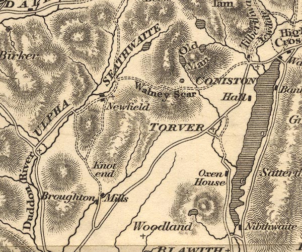 OT02SD29.jpg item:- JandMN : 48.1 Image © see bottom of page |
|
|
|
||
| evidence:- | descriptive text:- Ford 1839 (3rd edn 1843) placename:- Coniston Hall |
|
| source data:- | Guide book, A Description of Scenery in the Lake District, by
Rev William Ford, published by Charles Thurnam, Carlisle, by W
Edwards, 12 Ave Maria Lane, Charles Tilt, Fleet Street, William
Smith, 113 Fleet Street, London, by Currie and Bowman,
Newcastle, by Bancks and Co, Manchester, by Oliver and Boyd,
Edinburgh, and by Sinclair, Dumfries, 1839. goto source Page 9:- "..." "... Coniston Hall, the ancient seat of the Flemings of Rydal, is on the right hand on the edge of the lake, and although very much spoiled by alterations, is a pleasing object with the trees, the water, and the fells of Yewdale. ..." |
|
|
|
||
| evidence:- | old drawing:- Aspland 1840s-60s placename:- Coniston Old Hall |
|
| source data:- | Drawing, pencil, Coniston Hall, Coniston, Lancashire, by Theophilus Lindsey Aspland,
31 August 1869.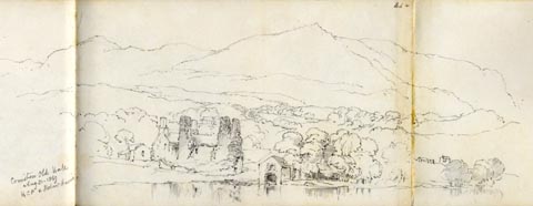 click to enlarge click to enlargeAS0652.jpg "Coniston Old Hall / Aug 31. 1869 / HCP & Robert Harr[is]" page number "44+" item:- Armitt Library : 2008.61.52 Image © see bottom of page |
|
|
|
||
| evidence:- | old map:- Garnett 1850s-60s H placename:- Coniston Hall |
|
| source data:- | Map of the English Lakes, in Cumberland, Westmorland and
Lancashire, scale about 3.5 miles to 1 inch, published by John
Garnett, Windermere, Westmorland, 1850s-60s.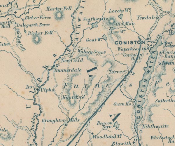 GAR2SD29.jpg "Coniston Hall" block, building item:- JandMN : 82.1 Image © see bottom of page |
|
|
|
||
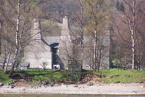
| evidence:- | database:- Listed Buildings 2010 placename:- Coniston Hall |
|
| source data:- | courtesy of English Heritage "CONISTON HALL / / / CONISTON / SOUTH LAKELAND / CUMBRIA / II[star] / 76807 / SD3048396364" |
|
| source data:- | courtesy of English Heritage "Large house, now part farmhouse, part used by sailing club, part ruined. Late C16, but south-west wing possibly earlier. Stone rubble with slate roof. T-plan with ruins of wing adjoining north-east angle. Entrance facade of 4 bays with gable end of ruined wing to left, the 4th bay projects under gable with re-entrant 2-storey porch under lean-to roof. Windows mostly have wooden chamfered-mullioned frames. Earth ramp with stone retaining walls to 2nd bay dates from C18 conversion to barn. Ground floor has 4-light window to 1st bay; casement to 3rd bay and 4th-bay casement with iron opening lights. 1st floor has 5- and 4-light mullioned windows with transoms flanking inserted barn entrance; 4th bay has 4-light transomed window. Entrance in re-entrant porch with 2-light window. Blocked 3-light attic window. Ruined wing has footings of walls; gable-end has ground floor fireplace with bressummer and 1st floor fireplace with 4-centred head; blocked entrances to 3 floors to right. In thickness of wall to left a garderobe with seat, now exposed. Right return has projecting lateral stack with round shaft on square base; windows with small-paned casements. Rear has gable-end and lateral stacks, as above. Ground floor 2-light windows; 1st floor has 2-light window to 1st, gabled, bay and 2-light window in deep recess to left of stack; end 2 bays have 4- and 5-light transomed windows. Left return has projecting stair turret in angle, with 2-light windows; gable-end stacks, that to ruined wing truncated. Interior: ground floor has stopped chamfered beams; 4-centred arch to fireplace; spiral stair has oak treads on stone; 1st floor has arch-braced collar trusses, one originally with partitions; deeply moulded architraves to panelling at upper end, late C16; 2 fireplaces with 4-centred heads. Farmhouse has plank and muntin partitions and panelled door possibly from screens. Property of The National Trust." |
|
|
|
||
| evidence:- | database:- Listed Buildings 2010 |
|
| source data:- | courtesy of English Heritage "PRIVY APPROXIMATELY 13 METRES TO SOUTH OF CONISTON HALL / / / CONISTON / SOUTH LAKELAND / CUMBRIA / II / 76808 / SD3047896341" |
|
| source data:- | courtesy of English Heritage "Privy. Possibly C19. Stone rubble with slate roof, now covered with ivy. Plank and batten door. Interior has plank seat with 2 holes, one with lid." |
|
|
|
||
 BLZ66.jpg (taken 28.4.2006) 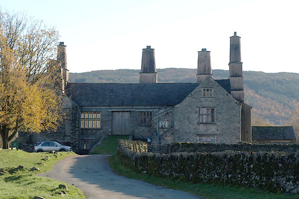 BTU28.jpg (taken 10.11.2010) |
||
|
|
||
| hearsay:- |
The Le Fleming Family lived here from 1250; they moved to Rydal Hall in the 18th century. |
|
|
|
||
| notes:- |
site of a tower 15th century hall |
|
| Perriam, D R &Robinson, J: 1998: Medieval Fortified Buildings of Cumbria: CWAAS::
ISBN 1 873124 23 6; plan and illustration |
||
|
|
||
Lakes Guides menu.