 Old Cumbria Gazetteer
 |
 |
|
| Derwent Isle, Derwent Water | ||
| Derwent Isle | ||
| Derwent Island | ||
| Hest Holm | ||
| Pocklington's Island | ||
| site name:- | Derwent Water | |
| civil parish:- | Keswick (formerly Cumberland) | |
| county:- | Cumbria | |
| locality type:- | island | |
| coordinates:- | NY26142239 (etc) | |
| 1Km square:- | NY2622 | |
| 10Km square:- | NY22 | |
|
|
||
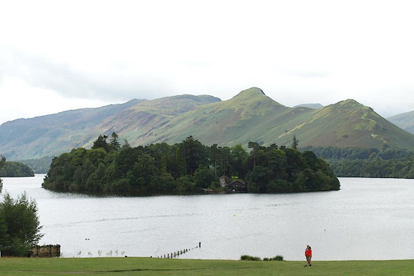 BPP94.jpg From Crow Park; Catbells behind. (taken 24.8.2008) 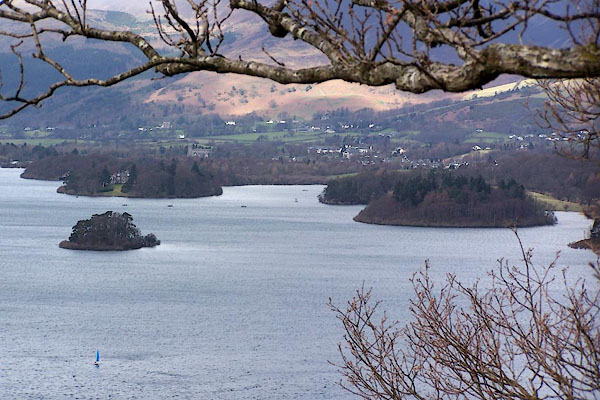 BLT86.jpg From Lowcrag Wood. (taken 3.4.2006) |
||
|
|
||
| evidence:- | old map:- OS County Series (Cmd 64 6) placename:- Derwent Isle |
|
| source data:- | Maps, County Series maps of Great Britain, scales 6 and 25
inches to 1 mile, published by the Ordnance Survey, Southampton,
Hampshire, from about 1863 to 1948. |
|
|
|
||
| evidence:- | old map:- Saxton 1579 placename:- Darwen Insul |
|
| source data:- | Map, hand coloured engraving, Westmorlandiae et Cumberlandiae Comitatus ie Westmorland
and Cumberland, scale about 5 miles to 1 inch, by Christopher Saxton, London, engraved
by Augustinus Ryther, 1576, published 1579-1645.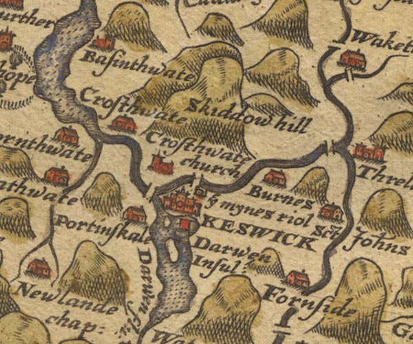 Sax9NY22.jpg "Darwen Insul" With a small building. item:- private collection : 2 Image © see bottom of page |
|
|
|
||
| evidence:- | old map:- Speed 1611 (Cmd) placename:- Darwen Iland |
|
| source data:- | Map, hand coloured engraving, Cumberland and the Ancient Citie
Carlile Described, scale about 4 miles to 1 inch, by John Speed,
1610, published by J Sudbury and George Humble, Popes Head
Alley, London, 1611-12.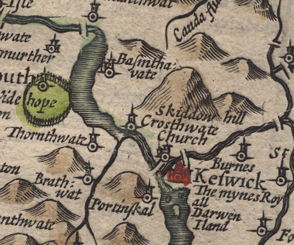 SP11NY22.jpg "Darwen Iland" island in Derwent Water item:- private collection : 16 Image © see bottom of page |
|
|
|
||
| evidence:- | poem:- Drayton 1612/1622 text placename:- Darwent Island item:- mines; copper mines; Company of Mines Royal; gold; silver |
|
| source data:- | Poem, Poly Olbion, by Michael Drayton, published by published by
John Marriott, John Grismand and Thomas Dewe, and others?
London, part 1 1612, part 2 1622. goto source goto sourcepage 165:- "... Darwent ... Doth quickly cast her selfe into an ample Lake, And with Thurls mighty Mere, betweene them two doe make An Island, which the name from Darwent doth derive, Within whose secret breast nice nature doth contrive, That mighty Copper Myne, which not without its Vaines, Of Gold and Silver found, it happily obtaines Of Royaltie the name, the richest of them all That Britan bringeth forth, which Royall she doth call." |
|
|
|
||
| evidence:- | old map:- Drayton 1612/1622 placename:- Darwen Island |
|
| source data:- | Map, hand coloured engraving, Cumberlande and Westmorlande, by
Michael Drayton, probably engraved by William Hole, scale about
4 or 5 miles to 1 inch, published by John Mariott, John
Grismand, and Thomas Dewe, London, 1622.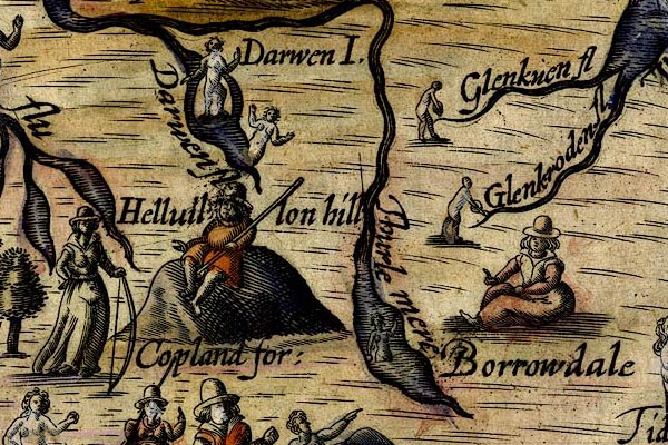 DRY514.jpg "Darwen I." Island, naiad by the island. item:- JandMN : 168 Image © see bottom of page |
|
|
|
||
| evidence:- | old map:- Jansson 1646 placename:- Darwen Iland |
|
| source data:- | Map, hand coloured engraving, Cumbria and Westmoria, ie
Cumberland and Westmorland, scale about 3.5 miles to 1 inch, by
John Jansson, Amsterdam, Netherlands, 1646.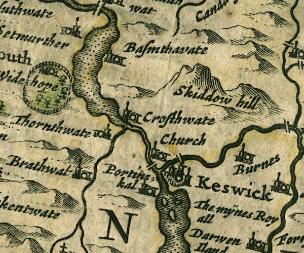 JAN3NY22.jpg "The mÿnes Royall / Darwen Iland" The label is alongside the lake, where the miners from Germany settled on the island. item:- JandMN : 88 Image © see bottom of page |
|
|
|
||
| evidence:- | old map:- Morden 1695 (Cmd) placename:- Darwen Iland |
|
| source data:- | Map, uncoloured engraving, Cumberland, scale about 4 miles to 1
inch, by Robert Morden, 1695, published by Abel Swale, the
Unicorn, St Paul's Churchyard, Awnsham, and John Churchill, the
Black Swan, Paternoster Row, London, 1695-1715.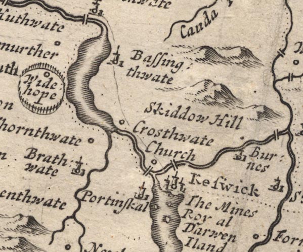 MD12NY22.jpg "The Mines Royal / Darwen Iland" Island; the miners from Germany settled on the island. item:- JandMN : 90 Image © see bottom of page |
|
|
|
||
| evidence:- | possibly descriptive text:- Simpson 1746 |
|
| source data:- | Atlas, three volumes of maps and descriptive text published as
'The Agreeable Historian, or the Compleat English Traveller
...', by Samuel Simpson, 1746. goto source "..." "... in which [Derwent Water] there are three Islands, one of them inhabited by German Miners; ..." |
|
|
|
||
| evidence:- | old map:- Gents Mag 1751 |
|
| source data:- | Map, uncoloured engraving, Map of the Black Lead Mines in
Cumberland, and area, scale about 2 miles to 1 inch, by George
Smith, published in the Gentleman's Magazine, 1751. GM1311.jpg island item:- JandMN : 114 Image © see bottom of page |
|
|
|
||
| evidence:- | old map:- Bowen and Kitchin 1760 |
|
| source data:- | Map, hand coloured engraving, A New Map of the Counties of
Cumberland and Westmoreland Divided into their Respective Wards,
scale about 4 miles to 1 inch, by Emanuel Bowen and Thomas
Kitchin et al, published by T Bowles, Robert Sayer, and John
Bowles, London, 1760.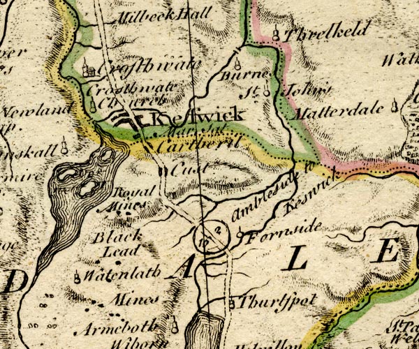 BO18NY21.jpg "Royal Mines" in Derwent Water, labelled on shore by the wrong island, Lord's Island; Derwent Isle was the base of the german miners. item:- Armitt Library : 2008.14.10 Image © see bottom of page |
|
|
|
||
| evidence:- | old map:- Donald 1774 (Cmd) |
|
| source data:- | Map, hand coloured engraving, 3x2 sheets, The County of Cumberland, scale about 1
inch to 1 mile, by Thomas Donald, engraved and published by Joseph Hodskinson, 29
Arundel Street, Strand, London, 1774. D4NY22SE.jpg island in Derwent Water item:- Carlisle Library : Map 2 Image © Carlisle Library |
|
|
|
||
| evidence:- | descriptive text:- West 1778 (11th edn 1821) placename:- Vicar's Isle placename:- Vicar's Island |
|
| source data:- | Guide book, A Guide to the Lakes, by Thomas West, published by
William Pennington, Kendal, Cumbria once Westmorland, and in
London, 1778 to 1821. goto source Page 90:- "[Derwent Water] ... Vicar's-isle rises in beautiful and circular form; ..." "..." goto sourcePage 111:- "... and a third [island] with a hut upon it, stript of its ornamental trees by the unfeeling hand of avarice [1]. ..." "[1] This third is Vicar's island, which has since been purchased by a gentleman, who has built a large mansion, and made some other improvements upon it." goto sourceAddendum; Mr Gray's Journal, 1769 Page 208:- "..." "[2] It is somewhat extraordinary that Mr. Gray omitted to mention the islands on Derwent-water, one of which, I think they call it Vicar's island, makes a principal object in the scene. See Smith's view of Derwent-water." |
|
|
|
||
| evidence:- | old map:- Crosthwaite 1783-94 (Der) placename:- Pocklington's Island |
|
| source data:- | Map, uncoloured engraving, An Accurate Map of the Matchless Lake
of Derwent, ie Derwent Water, scale about 3 inches to 1 mile, by
Peter Crosthwaite, Keswick, Cumberland, 1783, version published
1800. CT2NY22Q.jpg "Pocklington's Isld." In the map title:- "Pocklington's Island is the property of Lieut. Col Peachy" item:- Armitt Library : 1959.191.3 Image © see bottom of page |
|
|
|
||
| evidence:- | old map:- Crosthwaite 1783-94 placename:- Pocklington's Island |
|
| source data:- | Map, uncoloured engraving, Pocklington's Island, in Derwent
Water, by Joseph Pocklington, 1783, published by Peter
Crosthwaite, Keswick, Cumberland, 1783, version published 1800.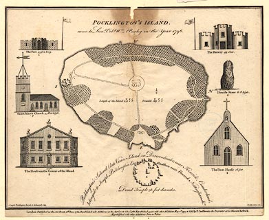 click to enlarge click to enlargeCT03.jpg item:- Armitt Library : 1959.191.6 Image © see bottom of page |
|
|
|
||
| evidence:- | probably old map:- West 1784 map |
|
| source data:- | Map, hand coloured engraving, A Map of the Lakes in Cumberland,
Westmorland and Lancashire, scale about 3.5 miles to 1 inch,
engraved by Paas, 53 Holborn, London, about 1784.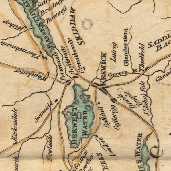 Ws02NY22.jpg item:- Armitt Library : A1221.1 Image © see bottom of page |
|
|
|
||
| evidence:- | old sketch map:- Gilpin 1786 placename:- Vicars Island |
|
| source data:- | Sketch map, Keswick Lake ie Derwent Water, Cumberland, by William Gilpin 1786 goto source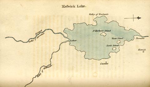 click to enlarge click to enlargeGLP312.jpg Plate vol 1 opposite p.179 in Observations on Picturesque Beauty published by T Cadell and W Davies, Strand, London, 1808. caption from the list of plates:- "This plan of Keswick-lake means only to express the general shape of it; and the relative situation of it's several parts." item:- Armitt Library : A918.12 Image © see bottom of page |
|
|
|
||
| evidence:- | old text:- Gilpin 1786 placename:- Vicar's Island |
|
| source data:- | Book, Observations, Relative Chiefly to Picturesque Beauty, Made
in the Year 1772, on Several Parts of England, Particularly the
Mountains, and Lakes of Cumberland Westmoreland, by Rev William
Gilpin, 1772-74; published 1786-1808. goto source vol.1 p.180 "The lake of Derwent, or Keswick-lake, as it is generally called, is contained within a circumference of about ten miles; presenting itself in a circular form, tho in fact it is rather oblong. It's area is interspersed with four or five islands; three of which only are of consequence, Lord's island, Vicar's island, and St. Herbert's island: but none of them is comparable to the island on Windermere, in point either of size, or beauty." goto sourcevol.1 p.184 "..." "To the formality of it's shores may be added the formality of it's islands. They are round, regular, and similar spots, as they appear from most points of view; formal in their situation, as well as in their shape; and of little advantage to the scene. ..." |
|
|
|
||
| evidence:- | old text:- Clarke 1787 placename:- Vicar's Island placename:- Pocklington' Island item:- fort; druidical temple |
|
| source data:- | Guide book, A Survey of the Lakes of Cumberland, Westmorland,
and Lancashire, written and published by James Clarke, Penrith,
Cumberland, and in London etc, 1787; published 1787-93. goto source Page 84:- "... Vicar's Island, now called, (from its proprietor) Pocklington's Island. This is one of the largest, and is beautifully ornamented by its spirited owner. On the western side he has built a fort, on which he has a battery, as before mentioned: on the South side of the fort is a druidical temple, exactly facing Keswick; and close to the shore is the appearance of a chapel, which consists of only one wall and a steeple: the steeple contains a room, not furnished with bells, but good roast-beef and claret; where the worthy Proprietor very facetiously said he might, he thought, always find more priests ready to attend, than at their own churches by the tinkling of bells. ..." |
|
|
|
||
| evidence:- | old map:- Clarke 1787 map (Der) placename:- Vicars Island |
|
| source data:- | Map, uncoloured engraving, Map of Derwentwater and its Environs,
scale about 13 ins to 1 mile, by James Clarke, engraved by S J
Neele, published by James Clarke, Penrith, Cumberland and in
London etc, 1787.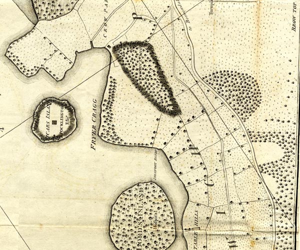 CL152622.jpg "VICARS ISLAND / POCKLINGTON Esqr." island, buildings item:- private collection : 169 Image © see bottom of page |
|
|
|
||
| evidence:- | old text:- Camden 1789 (Gough Additions) placename:- Vicar Isle |
|
| source data:- | Book, Britannia, or A Chorographical Description of the Flourishing Kingdoms of England,
Scotland, and Ireland, by William Camden, 1586, translated from the 1607 Latin edition
by Richard Gough, published London, 1789. goto source Page 182:- "..." ""... Vicar isle full of trees like a wilderness."" |
|
|
|
||
| evidence:- | old text:- Gents Mag |
|
| source data:- | Magazine, The Gentleman's Magazine or Monthly Intelligencer or
Historical Chronicle, published by Edward Cave under the
pseudonym Sylvanus Urban, and by other publishers, London,
monthly from 1731 to 1922. goto source Gentleman's Magazine 1805 p.1121 "... On the most considerable of this little archipelago [islands in Derwent Water] stands a tasteless mansion, the residence of a gentleman whose splendid regattas have acquired him an extensive celebrity in the county. ..." |
|
|
|
||
| evidence:- | old print:- Green 1810 (plate 31) |
|
| source data:- | Print, soft ground etching, Islands on Derwent Water from Castlerigg, Keswick, Cumberland,
by William Green, Ambleside, Westmorland, 1810.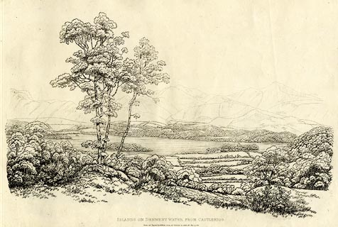 click to enlarge click to enlargeGN1231.jpg From near right to far - Derwent Isle, Lord's Island, St Herbert's Island? Plate 31 in Sixty Studies from Nature, 1810. printed at top right:- "31" printed at bottom:- "ISLANDS ON DERWENT WATER FROM CASTLERIGG. / Drawn and Engraved by William Green, and Published at Ambleside, June 24, 1810." watermark:- "J WHATMAN / 1813" item:- Armitt Library : A6641.31 Image © see bottom of page |
|
|
|
||
| evidence:- | old text:- Wordsworth 1810 placename:- Vicar's Island |
|
| source data:- | Guide book, A Description of the Scenery of the Lakes, later A
Guide through the District of The Lakes, by William Wordsworth,
1810-35. goto source page 62 "... At the bidding of an alien improver, the Hind's Cottage, upon Vicar's island, ... with its embowering sycamores and cattle-shed, disappeared from the corner where they stood; and right in the middle, and upon the precise point of the island's highest elevation, rose a tall square habitation, with four sides exposed, like an astronomer's observatory, or a warren-house reared upon an eminence for the detection of depredators, or, like the temple of OEolus, where all the winds pay him obeisance. Round this novel structure, but at a respectful distance, platoons of firs were stationed, as if to protect their commander when weather and time should somewhat have shattered his strength. Within the narrow limits of this island were typified also the state and strength of a kingdom, and its religion as it had been, and was, - for neither was the druidical circle" goto sourcepage 63 "uncreated, nor the church of the present essablishment (sic); nor the stately pier, emblem of commerce and navigation; nor the fort to deal out thunder upon the approaching invader. The taste of a succeeding proprietor rectified the mistakes as far as was practicable, and has ridded the spot of its puerilities. The church, after having been docked of its steeple, is applied both ostensibly and really, to the purpose for which the body of the pile was actually erected, namely a boat-house; the fort is demolished; and, without indignation on the part of the spirits of the ancient Druids who officiated at the circle upon the opposite hill, the mimic arrangement of stones, with its sanctum sanctorum, has been swept away." "The present instance has been singled out, extravagant as it is, because, unquestionably, this beautiful country has, in numerous other places, suffered from the same spirit, though not clothed exactly in the same form, nor active in an equal degree. ..." |
|
|
|
||
| evidence:- | old text:- Green 1814 placename:- Vicar's Island placename:- Pocklington's Island |
|
| source data:- | Set of prints, soft ground etchings, Sixty Small Prints, with
text, A Description of a Series of Sixty Small Prints, by
William Green, Ambleside, Westmorland, 1814. goto source page 17:- "... Vicar's Island (late Pocklington's Island), ..." |
|
|
|
||
| evidence:- | outline view:- Otley 1823 (8th edn 1849) placename:- Derwent Isle |
|
| source data:- | Engraving, outline view of mountains, Derwent Water from Crow Park, drawn by T Binns,
engraved by O Jewitt, opposite p.10 of A Descriptive Guide of the English Lakes, by
Jonathan Otley, 8th edition, 1849.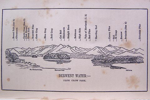 click to enlarge click to enlargeO80E06.jpg item:- Armitt Library : A1180.7 Image © see bottom of page |
|
|
|
||
| evidence:- | descriptive text:- Otley 1823 (5th edn 1834) placename:- Vicar's Isle placename:- Pocklington's Island item:- garden |
|
| source data:- | Guide book, A Concise Description of the English Lakes, the
mountains in their vicinity, and the roads by which they may be
visited, with remarks on the mineralogy and geology of the
district, by Jonathan Otley, published by the author, Keswick,
Cumberland now Cumbria, by J Richardson, London, and by Arthur
Foster, Kirkby Lonsdale, Cumbria, 1823; published 1823-49,
latterly as the Descriptive Guide to the English Lakes. goto source Page 17:- "The Vicar's Isle, belonging to General Peachy, contains about six acres, beautifully laid out in" goto sourcePage 18:- "pleasure grounds, interspersed with a variety of trees, and crowned with a house in the centre. For some years it was called Pocklington's Island, while it belonged to a gentleman of that name; and is sometimes by way of pre-eminence called Derwent Isle. ..." "..." |
|
| source data:- | Guide book, A Concise Description of the English Lakes, the
mountains in their vicinity, and the roads by which they may be
visited, with remarks on the mineralogy and geology of the
district, by Jonathan Otley, published by the author, Keswick,
Cumberland now Cumbria, by J Richardson, London, and by Arthur
Foster, Kirkby Lonsdale, Cumbria, 1823; published 1823-49,
latterly as the Descriptive Guide to the English Lakes. goto source Page 119:- "... Vicar's Isle, on which General Peachy has a house." goto sourcePage 120:- "... Coming in sight of the lake, Vicar's Isle is most happily placed, the house just appearing among a variety of forest trees with which the island seems wholly covered; but on inspection, it is found to be beautifully laid out in pleasure grounds, and kept in the neatest order. ..." |
|
|
|
||
| evidence:- | descriptive text:- Ford 1839 (3rd edn 1843) placename:- Vicar's Island |
|
| source data:- | Guide book, A Description of Scenery in the Lake District, by
Rev William Ford, published by Charles Thurnam, Carlisle, by W
Edwards, 12 Ave Maria Lane, Charles Tilt, Fleet Street, William
Smith, 113 Fleet Street, London, by Currie and Bowman,
Newcastle, by Bancks and Co, Manchester, by Oliver and Boyd,
Edinburgh, and by Sinclair, Dumfries, 1839. goto source Page 54:- "... The Vicar's Island, in olden times pertaining to Fountain's Abbey, now belonging to General Peachy, is beautifully laid out in pleasure-grounds, and crowned with a neat mansion, nearly hid amidst the variety of trees, having a view to the south only. ..." |
|
|
|
||
| evidence:- | old print:- |
|
| source data:- | Print, uncoloured engraving, Derwentwater with Derwent Isle, Cumberland, published
late 19th century?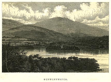 click to enlarge click to enlargePR0274.jpg Derwent Isle and its house in the midground. printed at bottom:- "DERWENTWATER." item:- Dove Cottage : 2008.107.274 Image © see bottom of page |
|
|
|
||
| evidence:- | outline view:- Black 1856 (23rd edn 1900) placename:- Derwent Isle |
|
| source data:- | Print, lithograph, Outline Views, Skiddaw and Derwent Water - Mountains as seen at
Lodore Hotel, and Mountains as seen at the Third Gate on Ascending Latrigg on the
Way to Skiddaw, by J Flintoft, Keswick, Cumberland, engraved by R Mason, Edinburgh,
Lothian, about 1900.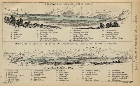 click to enlarge click to enlargeBC08E4.jpg "... Derwent Isle ..." item:- JandMN : 37.14 Image © see bottom of page |
|
|
|
||
| evidence:- | outline view:- Black 1841 (3rd edn 1846) placename:- Derwent Isle |
|
| source data:- | Print, engraving, outline view, Mountains as seen at Lowdore Inn, and Mountains as
seen at the Third Gate on Ascending Latrigg on the Way to Skiddaw, by J Flintoft,
Keswick, Cumberland, engraved by R Mason, Edinburgh, Lothian, about 1846.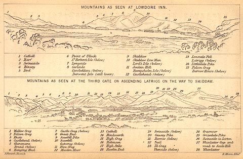 click to enlarge click to enlargeBC02E4.jpg "... Derwent Isle ..." item:- JandMN : 32.7 Image © see bottom of page |
|
|
|
||
| evidence:- | outline view:- Tattersall 1836 (version 1869) placename:- Vicar's Isle |
|
| source data:- | Print, hand coloured, Derwentwater and Bassenthwaite Lakes, from the road to Watendlath,
Cumberland, drawn by George Tattersall, 1836, engraved by W F Topham, published by
T J Allman, 463 Oxford Street, London, 1869.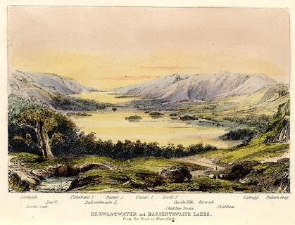 click to enlarge click to enlargeTAT212.jpg Included in The Lakes of England, by W F Topham. printed at bottom:- "DERWENTWATER and BASSENTHWAITE LAKES, / from the road to Watendlath." printed at bottom:- "Swinside. / Lord's Seat. / Barff. / St. Herbert's I. / Bassenthwaite L. / Ramps I. / Vicar's I. / Lord's I. / Skiddaw Dodd. / Castle Hill. / Keswick. / Skiddaw. / Latrigg. / Falcon Crag." item:- Armitt Library : A1067.12 Image © see bottom of page |
|
|
|
||
| evidence:- | outline view:- Tattersall 1836 placename:- Vicar's Isle |
|
| source data:- | Print, engraving, View from Skiddaw, looking South, Cumberland, Westmorland and Lancashire,
drawn by George Tattersall, engraved by W F Topham, published by Sherwood and Co,
Paternoster Row, London, about 1836.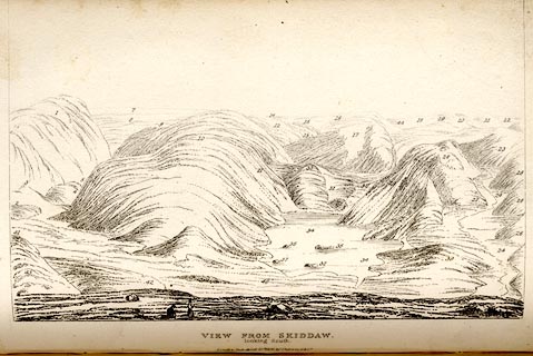 click to enlarge click to enlargeTAT137.jpg The print is captioned with mountain names and acts as an outline view. Tipped in opposite p.91 of The Lakes of England, by George Tattersall. printed at bottom:- "VIEW FROM SKIDDAW, / looking South. / [London Pubd. ...]" printed at p.91:- "... FOUR VIEWS FROM THE SUMMIT OF SKIDDAW. III. LOOKING SOUTH. / ... / 38. Vicar's Ilse, Derwentwater. / ..." item:- Armitt Library : A1204.38 Image © see bottom of page |
|
|
|
||
| evidence:- | outline view:- Tattersall 1836 placename:- Vicar's Isle |
|
| source data:- | Print, engraving, Derwentwater and Bassenthwaite Lakes, from the road to Watenflath,
Cumberland, drawn by George Tattersall, engraved by W F Topham, published by Sherwood
and Co, Paternoster Row, London, about 1836. click to enlarge click to enlargeTAT130.jpg The print is captioned with mountain names and acts as an outline view. Tipped in opposite p.77 of The Lakes of England, by George Tattersall. printed at bottom:- "DERWENTWATER and BASSENTHWAITE LAKES, / from the road to Watendlath." printed at bottom left to right:- "Swinside. / Lord's Seat. / Barff. / St. Herbert's I. / Bassenthwaite L. / Ramp's I. / Vicar's I. / Lord's I. / Skiddaw Dodd. / Castle Hill. / Keswick. / Skiddaw. / Latrigg. / Falcon Crag." item:- Armitt Library : A1204.31 Image © see bottom of page |
|
|
|
||
| evidence:- | outline view:- placename:- Vicar's Island |
|
| source data:- | Print, uncoloured engraving, Derwentwater and Bassenthwaite Lakes from the Road to
Watendlath, Cumberland, published by Sherwood and Co, London, 1836?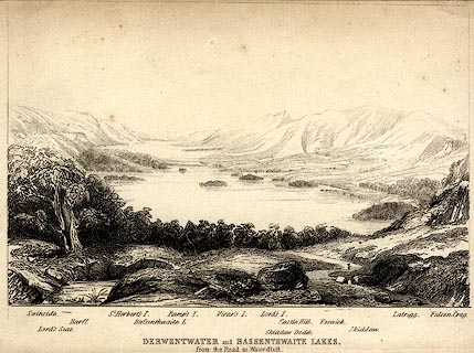 click to enlarge click to enlargePR0370.jpg The view is from just above Ashness Bridge. Objects in the view are identified by a caption at the bottom (unfortunately the print is pale, so some objects are unclear, and the caption seems to be a little misaligned) - Swinside, Lord's Seat, Barff, St. Herbert's I., Bassenthwaite L., Ramp's I., Vicar's I., Lord's I., Skiddaw Dodd, Castle Hill, Keswick, Skiddaw, Latrigg, Falcon Crag. printed at bottom:- "DERWENTWATER and BASSENTHWAITE LAKES. / from the Road to Watendlath." item:- Dove Cottage : 2008.107.370 Image © see bottom of page |
|
|
|
||
| evidence:- | old print:- |
|
| source data:- | Print, aquatint, Derwent Water including Derwent Isle, Cumberland, drawn by Becker,
published by R Crutterell, Bath, Somerset, 1802.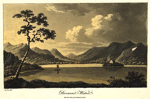 click to enlarge click to enlargePR0438.jpg Derwent Isle and its house in the midground. A companion print has the publisher as Cruttwell. printed at bottom left, centre:- "Becker del. / Derwent-Water. / Pub. Jan. 1 1802, by R. Crutterell, Bath." item:- private collection : 102 Image © see bottom of page |
|
|
|
||
| evidence:- | old print:- placename:- Pocklington's Island item:- boat; rowing boat; landing stage; house item:- Pocklington |
|
| source data:- | Print, uncoloured engraving, A View from the North of Pocklington's Island, ie Derwent
Island? Keswick, Cumberland, drawn by Joseph Pocklington, engraved by Samuel Middiman,
1787.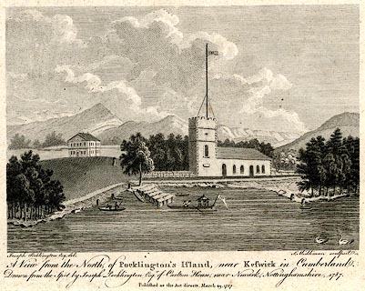 click to enlarge click to enlargePR0536.jpg Included in The History of the County of Cumberland, by William Hutchinson, published by Law and Son, Clarke, and Taylor, London, 1794. printed at bottom:- "Joseph Pocklington Esq. del. S. Middiman sculpsit. / A View from the North, of Pocklington's Island, near Keswick in Cumberland. / Drawn from the Spot by Joseph Pocklington Esqr. of Carlton House, near Newark, Nottinghamshire. 1786. / Published as the Act directs, March 29, 1787." item:- Dove Cottage : 2008.107.485 Image © see bottom of page |
|
|
|
||
| evidence:- | old print:- Lowther 1780s-90s placename:- Derwent Isle placename:- Pocklington's Island |
|
| source data:- | Print, engraving, Pocklington's Island, drawn by Joseph Pocklington, engraved by Samuel
Middiman, published 1786.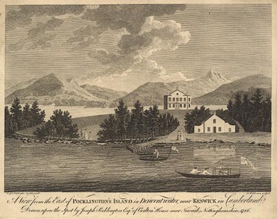 click to enlarge click to enlargeBMZ91.jpg item:- Dove Cottage : Lowther.55 Image © see bottom of page |
|
|
|
||
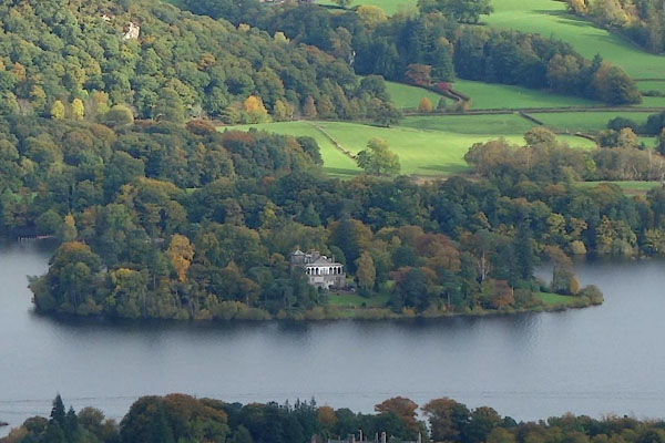 BZO07.jpg (taken 24.10.2013) |
||
|
|
||
| hearsay:- |
Joseph Pocklington bought the island, 1778 or 1781, and declared himself its governor;
he was called as King Pocky. Pocklington's fort, battery, chapel, druid's circle,
and boat house, are now all ruins; nothing to see. |
|
|
|
||
| hearsay:- |
The miners from Ausberg, Germany settled here and were involved in prospecting and
mining in the surrounding area in the 16th century. They operated as the Company of
Mines Royal. |
|
|
|
||
Lakes Guides menu.