 |
 |
|
|
|
|
|
|
|
Docker |
| county:- |
Cumbria |
| old county:- |
Westmorland |
| locality type:- |
parish |
| 1Km square:- |
SD5594 |
| 10Km square:- |
SD59 |
| references:- |
OS 1974 Admin Areas
|
|
|
| evidence:- |
hearth tax returns:- Hearth Tax 1670
placename:- Docker
|
| source data:- |
Records, hearth tax returns, exchequer duplicates, Westmorland,
1670.
"Docker"
|
|
|
| evidence:- |
old map:- Cary 1789 (edn 1805)
placename:- Docker
|
| source data:- |
Map, uncoloured engraving, Westmoreland, scale about 2.5 miles
to 1 inch, by John Cary, London, 1789; edition 1805.
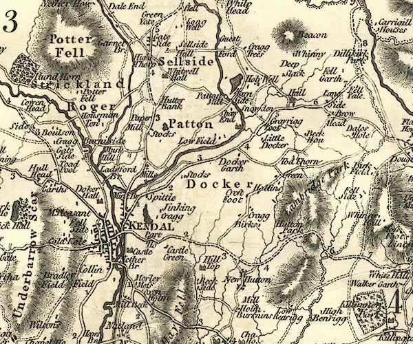
CY24SD59.jpg
"Docker"
area
item:- JandMN : 129
Image © see bottom of page
|
|
|
| evidence:- |
census:- Census 1971
|
|
Population: 55 (1971) |
|
|
| places:- |
 |
SD55649571 Appleby Road Bridge, Docker |
|
|
|
SD54939555 boundary stone, Docker/Scalthwaiterigg |
|
|
|
SD55989401 Coalbank Wood, Docker |
|
|
|
SD56549425 Croft Foot, Docker |
|
|
|
SD562955 Docker |
|
|
|
SD56559630 Docker Bridge, Docker |
|
|
|
SD57699404 Docker Fell, Docker |
|
|
|
SD56249540 Docker Garth, Docker |
|
|
|
SD56229555 Docker Hall, Docker |
|
|
|
SD55349484 Docker Parks, Docker |
|
|
|
SD55149456 Dockergarths Plantation, Docker |
|
|
|
SD56749446 Dubside, Docker gone? |
|
|
|
SD5695 Flodder Beck |
|
|
|
SD5695 forest, Docker |
|
|
|
SD56989456 Haygarth, Docker |
|
|
|
SD55529412 High Park, Docker |
|
|
|
SD57289503 Hollins, Docker |
|
|
|
SD5794 Kitchengill Beck |
|
|
|
SD5696 Lambrigg Beck |
|
|
|
SD55829432 Light Howe, Docker |
|
|
|
SD56729618 Little Docker, Docker |
|
|
|
SD5695 Lonning, Docker once? |
|
|
|
SD56219472 Low Barns, Docker |
|
|
|
SD56179608 milestone, Docker perhaps once |
|
|
|
SD56749618 Mill House, Docker |
|
|
|
SD5596 Mint, River |
|
|
|
SD56599396 Myers, Docker |
|
|
|
SD55229584 Oldfield Wood, Docker |
|
|
|
SD55979627 Oldfield, Docker |
|
|
|
SD5594 Park Beck (3) |
|
|
|
SD56209568 railway bridge, Docker |
|
|
|
SD56229566 railway milepost, Docker |
|
|
|
SD55899504 Slough, Docker |
|
|
|
SD5589 St Sunday's Beck |
|
|
|
SD56269540 Tenter End, Docker |
|
|
|
SD56209426 Wray Farm, Docker |
|
|
|
Lancaster and Carlisle Railway |
|
