 Old Cumbria Gazetteer
 |
 |
|
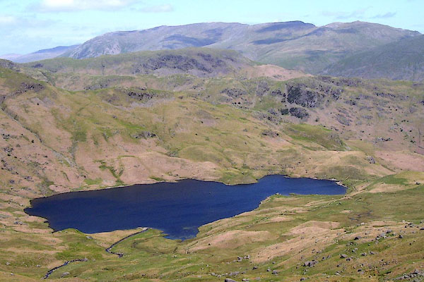
| Easedale Tarn, Easedale | ||
| runs into:- |  Sour Milk Gill (3) Sour Milk Gill (3) |
|
|
|
||
| Easedale Tarn | ||
| locality:- | Grasmere Common | |
| locality:- | Far Easedale | |
| locality:- | Easedale | |
| civil parish:- | Lakes (formerly Westmorland) | |
| county:- | Cumbria | |
| locality type:- | tarn | |
| coordinates:- | NY30730876 (etc) | |
| 1Km square:- | NY3008 | |
| 10Km square:- | NY30 | |
| altitude:- | 948 feet | |
| altitude:- | 289m | |
|
|
||
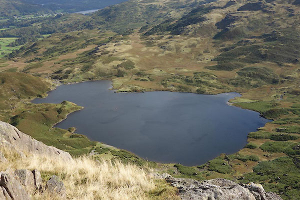 CBU26.jpg (taken 24.9.2014) 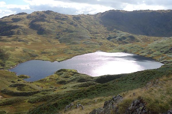 CBU27.jpg (taken 24.9.2014) |
||
|
|
||
| evidence:- | old map:- OS County Series (Wmd 18 15) placename:- Easedale Tarn |
|
| source data:- | Maps, County Series maps of Great Britain, scales 6 and 25
inches to 1 mile, published by the Ordnance Survey, Southampton,
Hampshire, from about 1863 to 1948. |
|
|
|
||
| evidence:- | old map:- Saxton 1579 |
|
| source data:- | Map, hand coloured engraving, Westmorlandiae et Cumberlandiae Comitatus ie Westmorland
and Cumberland, scale about 5 miles to 1 inch, by Christopher Saxton, London, engraved
by Augustinus Ryther, 1576, published 1579-1645. Sax9NY21.jpg item:- private collection : 2 Image © see bottom of page |
|
|
|
||
| evidence:- | old map:- Speed 1611 (Wmd) |
|
| source data:- | Map, hand coloured engraving, The Countie Westmorland and
Kendale the Cheif Towne, scale about 2.5 miles to 1 inch, by
John Speed, 1610, published by George Humble, Popes Head Alley,
London, 1611-12. SP14NY31.jpg outline, shaded item:- Armitt Library : 2008.14.5 Image © see bottom of page |
|
|
|
||
| evidence:- | old map:- Morden 1695 (Wmd) |
|
| source data:- | Map, hand coloured engraving, Westmorland, scale about 2.5 miles to 1 inch, by Robert
Morden, published by Abel Swale, the Unicorn, St Paul's Churchyard, Awnsham, and John
Churchill, the Black Swan, Paternoster Row, London, 1695.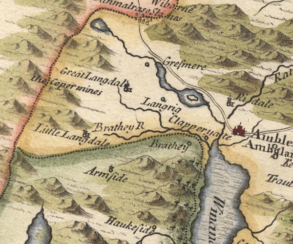 MD10NY30.jpg Outline with shore shading, tinted blue. item:- JandMN : 24 Image © see bottom of page |
|
|
|
||
| evidence:- | possibly old map:- Badeslade 1742 placename:- |
|
| source data:- | Map, uncoloured engraving, A Map of Westmorland North from
London, scale about 10 miles to 1 inch, with descriptive text,
by Thomas Badeslade, London, engraved and published by William
Henry Toms, Union Court, Holborn, London, 1742. click to enlarge click to enlargeBD12.jpg "" outline with form lines item:- Dove Cottage : 2007.38.62 Image © see bottom of page |
|
|
|
||
| evidence:- | old map:- Simpson 1746 map (Wmd) |
|
| source data:- | Map, uncoloured engraving, Westmorland, scale about 8 miles to 1
inch, printed by R Walker, Fleet Lane, London, 1746.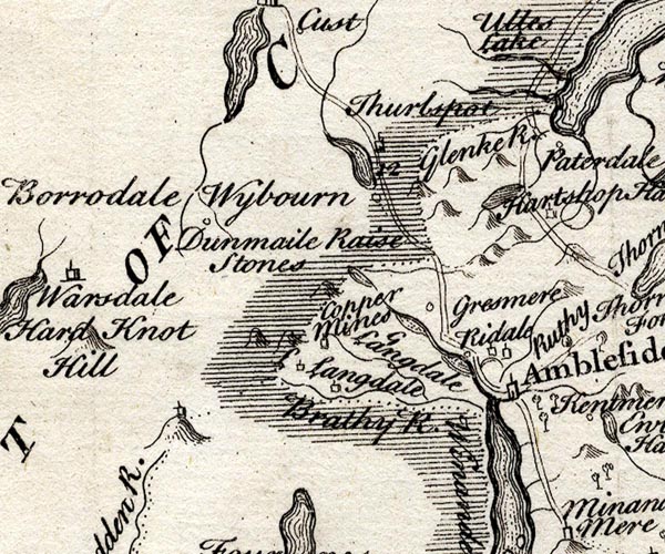 SMP2NYF.jpg Outline with form lines. item:- Dove Cottage : 2007.38.59 Image © see bottom of page |
|
|
|
||
| evidence:- | old map:- Bowen and Kitchin 1760 |
|
| source data:- | Map, hand coloured engraving, A New Map of the Counties of
Cumberland and Westmoreland Divided into their Respective Wards,
scale about 4 miles to 1 inch, by Emanuel Bowen and Thomas
Kitchin et al, published by T Bowles, Robert Sayer, and John
Bowles, London, 1760. BO18NY20.jpg outline with form lines item:- Armitt Library : 2008.14.10 Image © see bottom of page |
|
|
|
||
| evidence:- | old map:- Jefferys 1770 (Wmd) |
|
| source data:- | Map, 4 sheets, The County of Westmoreland, scale 1 inch to 1
mile, surveyed 1768, and engraved and published by Thomas
Jefferys, London, 1770. J5NY31SW.jpg outline with form lines; lake or tarn item:- National Library of Scotland : EME.s.47 Image © National Library of Scotland |
|
|
|
||
| evidence:- | old map:- West 1784 map |
|
| source data:- | Map, hand coloured engraving, A Map of the Lakes in Cumberland,
Westmorland and Lancashire, scale about 3.5 miles to 1 inch,
engraved by Paas, 53 Holborn, London, about 1784. Ws02NY20.jpg item:- Armitt Library : A1221.1 Image © see bottom of page |
|
|
|
||
| evidence:- | old map:- Cary 1789 (edn 1805) |
|
| source data:- | Map, uncoloured engraving, Westmoreland, scale about 2.5 miles
to 1 inch, by John Cary, London, 1789; edition 1805. CY24NY31.jpg outline with shore form lines; lake or tarn item:- JandMN : 129 Image © see bottom of page |
|
|
|
||
| evidence:- | old map:- Cooke 1802 |
|
| source data:- | Map, The Lakes, Westmorland and Cumberland, scale about 8.5
miles to 1 inch, engravedby Neele and Son, published by
Sherwood, Jones and Co, Paternoster Road, London, 1824. click to enlarge click to enlargeGRA1Lk.jpg outline with form lines; lake or tarn item:- Hampshire Museums : FA2000.62.5 Image © see bottom of page |
|
|
|
||
| evidence:- | old map:- Cooper 1808 |
|
| source data:- | Map, hand coloured engraving, Westmoreland ie Westmorland, scale
about 9 miles to 1 inch, by H Cooper, 1808, published by R
Phillips, Bridge Street, Blackfriars, London, 1808. click to enlarge click to enlargeCOP4.jpg outline, shaded; lake item:- Dove Cottage : 2007.38.53 Image © see bottom of page |
|
|
|
||
| evidence:- | old text:- Green 1814 placename:- Easedale Tarn |
|
| source data:- | Set of prints, soft ground etchings, Sixty Small Prints, with
text, A Description of a Series of Sixty Small Prints, by
William Green, Ambleside, Westmorland, 1814. goto source page 13:- "... Easedale Tarn, which will be found by following the frothy stream, is engulphed in precipitous mountains, with large rocks projecting from their sides." |
|
|
|
||
| evidence:- | old print:- Green 1815 placename:- Easedale Tarn |
|
| source data:- | Print, coloured aquatint, Easedale Tarn, Easedale, Westmorland, by William Green,
Ambleside, Westmorland, 1815.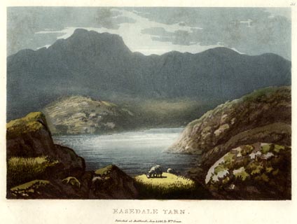 click to enlarge click to enlargeGN0529.jpg Plate 31 in Lake Scenery. printed at upper right:- "31" printed at bottom:- "EASEDALE TARN. / Published at Ambleside, June 1, 1815, by Wm. Green." item:- Armitt Library : A6646.29 Image © see bottom of page |
|
|
|
||
| evidence:- | old map:- Otley 1818 |
|
| source data:- | Map, uncoloured engraving, The District of the Lakes,
Cumberland, Westmorland, and Lancashire, scale about 4 miles to
1 inch, by Jonathan Otley, 1818, engraved by J and G Menzies,
Edinburgh, Scotland, published by Jonathan Otley, Keswick,
Cumberland, et al, 1833. OT02NY30.jpg item:- JandMN : 48.1 Image © see bottom of page |
|
|
|
||
| evidence:- | descriptive text:- Otley 1823 (5th edn 1834) placename:- Easdale Tarn |
|
| source data:- | Guide book, A Concise Description of the English Lakes, the
mountains in their vicinity, and the roads by which they may be
visited, with remarks on the mineralogy and geology of the
district, by Jonathan Otley, published by the author, Keswick,
Cumberland now Cumbria, by J Richardson, London, and by Arthur
Foster, Kirkby Lonsdale, Cumbria, 1823; published 1823-49,
latterly as the Descriptive Guide to the English Lakes. goto source Page 34:- "... Easdale Tarn, which is one of the largest mountain tarns, seated in the western branch of Grasmere vale among rocky precipices, of which Blakerigg, or Blea Crag, is the principal. Its stream - from its frothy whiteness called Sour-milk Gill - is a striking object from the road. ..." |
|
|
|
||
| evidence:- | possibly old map:- Perrot 1823 |
|
| source data:- | Map, hand coloured engraving, Cumberland and Westmoreland ie
Westmorland, scale about 38 miles to 1 inch, by Aristide Michel
Perrot, engraved by Migneret, 1823, published by Etienne Ledoux,
9 Rue Guenegaud, Paris, France, 1824-48. click to enlarge click to enlargePER2.jpg outline with form lines; lake item:- Dove Cottage : 2007.38.45 Image © see bottom of page |
|
|
|
||
| evidence:- | old drawing:- Aspland 1840s-60s placename:- Easedale Tarn |
|
| source data:- | Drawing, pencil, Easedale Tarn from Helm Crag, Westmorland, by Theophilus Lindsey
Aspland, 1857.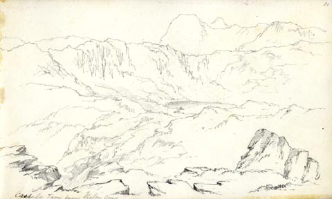 click to enlarge click to enlargeAS0514.jpg "Easdale Tarn from Helm Crag" page number "11" item:- Armitt Library : 1958.389.14 Image © see bottom of page |
|
|
|
||
| evidence:- | old map:- Garnett 1850s-60s H placename:- Easedale Tarn |
|
| source data:- | Map of the English Lakes, in Cumberland, Westmorland and
Lancashire, scale about 3.5 miles to 1 inch, published by John
Garnett, Windermere, Westmorland, 1850s-60s.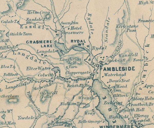 GAR2NY30.jpg "Easedale T." outline with shore form lines, lake or tarn item:- JandMN : 82.1 Image © see bottom of page |
|
|
|
||
| evidence:- | old text:- Martineau 1855 item:- sundial |
|
| source data:- | Guide book, A Complete Guide to the English Lakes, by Harriet
Martineau, published by John Garnett, Windermere, Westmorland,
and by Whittaker and Co, London, 1855; published 1855-76. goto source Page 51:- "... Up and on he goes, ... and at last, when he is heated and breathless, the dark cool recess opens in which lies Easedale Tarn. Perhaps there is an angler standing besides the great boulder on the brink. Perhaps there is a shepherd lying among the ferns. But more probably the stranger finds himself perfectly alone. There is perhaps nothing in natural scenery which conveys such an impression of stillness as tarns which lie under precipices: and here the rocks sweep down to the brink almost round the entire margin. For hours together the deep shadows move only like the gnomon of the sundial; and, when movement occurs, it is not such as disturbs the sense of repose;- the dimple made by a restless fish or fly, or the gentle flow of water in or out; or the wild drake and his brood, paddling so quietly as not to break up the mirror, or the reflection of some touch of sunlight, or passing shadow." goto sourcePage 52:- "If there is commotion from gusts or eddies of wind, the effect is even more remarkable. Little white clouds are driven against the rocks,- the spray is spilled in unexpected places; now the precipices are wholly veiled, and there is nothing but the ruffled water to be seen: and again, in an instant, the rocks are disclosed so fearfully that they seem to be crowding together to crush the intruder. If this seems to the inexperienced like extravagance, let him go alone to Easedale Tarn, or to Angle Tarn on Bowfell, on a gusty day, and see what he will find." |
|
|
|
||
| evidence:- | old print:- Payn 1867 placename:- Easedale Tarn |
|
| source data:- | Print, uncoloured engraving, Easedale Tarn, near Grasmere, Westmorland, by T L Aspland,
engraved by W T Green, published by J Garnett, Windermere, Westmorland, 1867.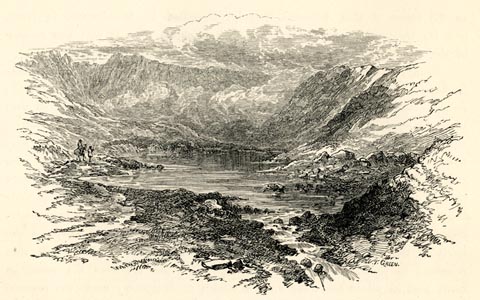 click to enlarge click to enlargePN0346.jpg On p.86 of The Lakes in Sunshine, text by James Payn. printed at lower right:- "W. T. GREEN." item:- Fell and Rock Climbing Club : 184.46 Image © see bottom of page |
|
|
|
||
| evidence:- | old photograph:- Bell 1880s-1940s |
|
| source data:- | Photograph, black and white, Easedale Tarn, Westmorland, by Herbert Bell, Ambleside,
Westmorland, 1890s.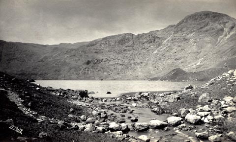 click to enlarge click to enlargeHB0516.jpg internegative at lower left:- "H. Bell" item:- Armitt Library : ALPS179 Image © see bottom of page |
|
|
|
||
| evidence:- | old print:- Goodwin 1887 (edn 1890) placename:- Easedale Tarn |
|
| source data:- | Print, etching? Easedale Tarn, Easedale, Westmorland, by Harry Goodwin, published
by Swan Sonnenschein and Co, Paternoster Square, London, 1890.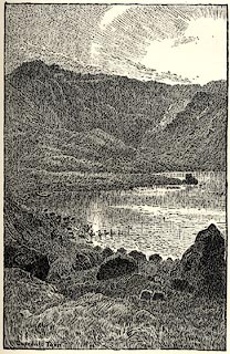 click to enlarge click to enlargePR1596.jpg Tipped in opposite p.128 of Through the Wordsworth Country, by William Knight. printed at lower left:- "Easedale Tarn" item:- JandMN : 382.26 Image © see bottom of page |
|
|
|
||
| evidence:- | perhaps old painting:- |
|
| source data:- | Painting, watercolour, Easedale near Grasmere, Westmorland, by Edward Arden, 1880s-90s.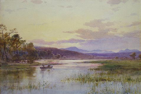 click to enlarge click to enlargePR1280.jpg Sunset scene of a lake; a rowing boat is guided between the reedbeds towards the open water by one man whilst a second man fishes. signed at bottom left:- "Edward Arden" annotated at reverse:- "Edward Arden Easedale near Grasmere" item:- Tullie House Museum : 1978.108.111 Image © Tullie House Museum |
|
|
|
||
| evidence:- | old drawing:- Brockbank 1870s placename:- Easedale Tarn |
|
| source data:- | Drawing, ink and ink wash, glacial moriane at foot of Easedale Tarn, Easedale, Grasmere,
Westmorland, 1870s, used by William Brockbank.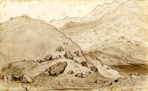 click to enlarge click to enlargePR1918.jpg "Easedale No 1." "Moraines / Easdale. / W. Brockbank F.G.S. / 13" "Conical Hill at foot of Easedale Tarn. Has a rockb[ase] but / is covered with moraine matter and evidently owes its / form to glacial action. Has many large perched blocks / upon it. / The foot of Easedale Tarn is closed in by / moraines & the whole valley is peculiarly rich in every / variety of glacial evidence. It widens out at its head / into a very wide basin, which has evidently held a / large glacier in former times." item:- Armitt Library : 1959.68.13 Image © see bottom of page |
|
|
|
||
| evidence:- | old drawing:- Brockbank 1870s placename:- Easedale Tarn |
|
| source data:- | Drawing, ink and ink wash, glacial moriane at foot of Easedale Tarn, Easedale, Grasmere,
Westmorland, 1870s, used by William Brockbank.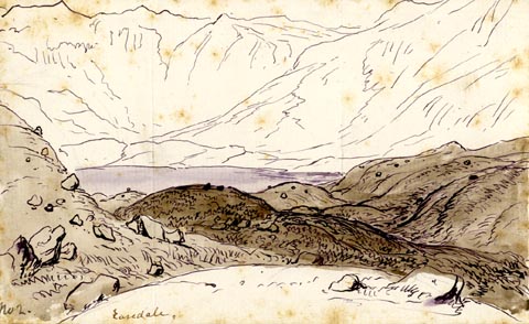 click to enlarge click to enlargePR1917.jpg "No 2. Easedale." "Moraine at foot of Easdale Tarn / W. Brockbank F.G.S. / 12" item:- Armitt Library : 1959.68.12 Image © see bottom of page |
|
|
|
||
 BNR33.jpg (taken 22.5.2007) 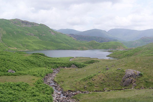 BSX42.jpg (taken 27.6.2010) |
||
|
|
||
Lakes Guides menu.