 Old Cumbria Gazetteer
 |
 |
|
| Skirwith Hall, Skirwith | ||
| Skirwith Hall | ||
| locality:- | Skirwith | |
| civil parish:- | Culgaith (formerly Cumberland) | |
| county:- | Cumbria | |
| locality type:- | buildings | |
| coordinates:- | NY61053259 | |
| 1Km square:- | NY6132 | |
| 10Km square:- | NY63 | |
|
|
||
| evidence:- | old map:- OS County Series (Cmd 50 16) placename:- Skirwith Hall |
|
| source data:- | Maps, County Series maps of Great Britain, scales 6 and 25
inches to 1 mile, published by the Ordnance Survey, Southampton,
Hampshire, from about 1863 to 1948. |
|
|
|
||
| evidence:- | old map:- Donald 1774 (Cmd) |
|
| source data:- | Map, hand coloured engraving, 3x2 sheets, The County of Cumberland, scale about 1
inch to 1 mile, by Thomas Donald, engraved and published by Joseph Hodskinson, 29
Arundel Street, Strand, London, 1774.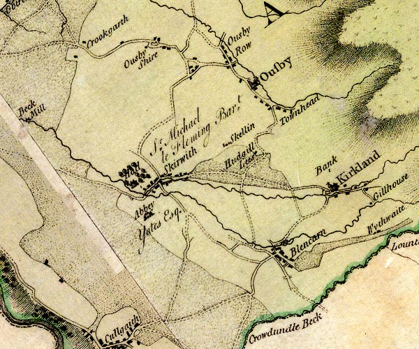 D4NY63SW.jpg "Hall / Sr. Michael le Fleming Bart." house at Skirwith item:- Carlisle Library : Map 2 Image © Carlisle Library |
|
|
|
||
| evidence:- | road book:- Cary 1798 (2nd edn 1802) placename:- Skirwith Hall |
|
| source data:- | Road book, itineraries, Cary's New Itinerary, by John Cary, 181
Strand, London, 2nd edn 1802. goto source goto source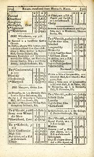 click to enlarge click to enlargeC38319.jpg page 319-320 "About 3 Miles on r. of Longwathby is Skirwith Hall, J. O. Yates, Esq." item:- JandMN : 228.1 Image © see bottom of page |
|
|
|
||
Lakes Guides menu.