 Old Cumbria Gazetteer
 |
 |
|
| Harrison Stickle, Lakes | ||
| Harrison Stickle | ||
| site name:- | Langdale Pikes | |
| civil parish:- | Lakes (formerly Westmorland) | |
| county:- | Cumbria | |
| locality type:- | hill | |
| locality type:- | rocks | |
| coordinates:- | NY28170736 (etc) | |
| 1Km square:- | NY2807 | |
| 10Km square:- | NY20 | |
|
|
||
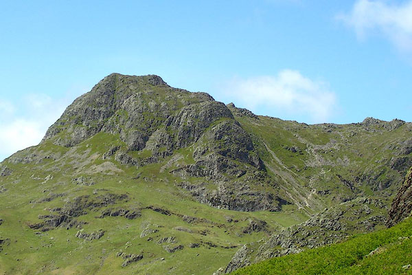
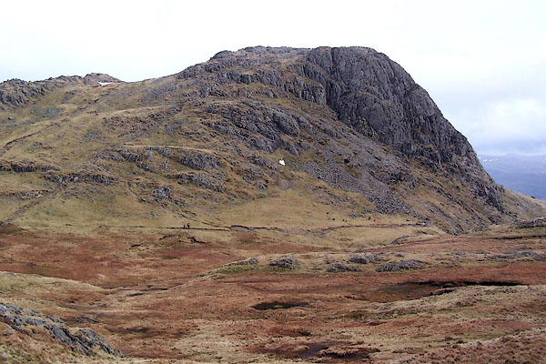 BSI95.jpg (taken 23.3.2010) 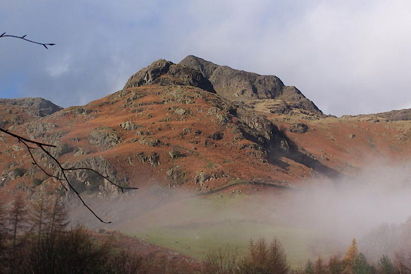 BLK80.jpg (taken 5.12.2005) |
||
|
|
||
| evidence:- | old map:- OS County Series (Wmd 25 2) placename:- Harrison Stickle |
|
| source data:- | Maps, County Series maps of Great Britain, scales 6 and 25
inches to 1 mile, published by the Ordnance Survey, Southampton,
Hampshire, from about 1863 to 1948. |
|
|
|
||
| evidence:- | outline view:- Otley 1823 (4th edn 1830) placename:- Harrison Stickle |
|
| source data:- | Print, engraving, outline view, Mountains of Coniston, Langdale, &c. as they appear
from the road between Troutbeck Bridge and Bowness, published by Jonathan Otley, Keswick,
Cumberland et al, 1830.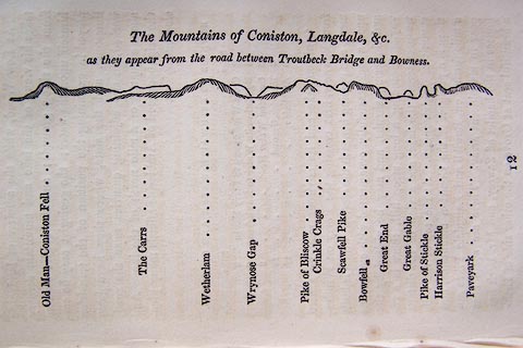 click to enlarge click to enlargeO75E04.jpg p.97 in A Concise Description of the English Lakes, by Jonathan Otley, 4th edition, 1830. "The Mountains of Coniston, Langdale, &c. / as they appear from the road between Troutbeck Bridge and Bowness." "Old Man - Coniston Fell / The Carrs / Wetherlam / Wrynose Gap / Pike of Bliscow / Crinkle Crags / Scawfell Pike / Bowfell / Great End / Great Gable / Pike of Stickle / Harrison Stickle / Paveyark" item:- Armitt Library : A1175.4 Image © see bottom of page |
|
|
|
||
| evidence:- | outline view:- Otley 1823 (8th edn 1849) placename:- Harrison Stickle |
|
| source data:- | Engraving, outline view of mountains, Windermere looking towards the West from the
Road between Troutbeck and Bowness, drawn by T Binns, engraved by O Jewitt, opposite
p.4 of A Descriptive Guide of the English Lakes, by Jonathan Otley, 8th edition, 1849.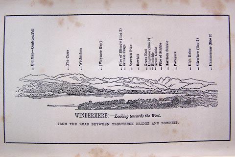 click to enlarge click to enlargeO80E03.jpg item:- Armitt Library : A1180.4 Image © see bottom of page |
|
|
|
||
| evidence:- | outline view:- Otley 1823 (8th edn 1849) placename:- Harrison Stickle |
|
| source data:- | Engraving, outline view of mountains, A Group of Mountains seen from Helvellyn, looking
towards the South West, drawn by T Binns, engraved by O Jewitt, opposite p.50 of A
Descriptive Guide of the English Lakes, by Jonathan Otley, 8th edition, 1849.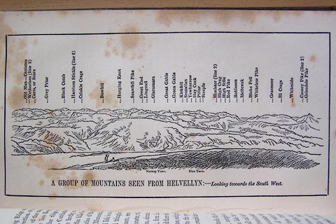 click to enlarge click to enlargeO80E17.jpg item:- Armitt Library : A1180.18 Image © see bottom of page |
|
|
|
||
| evidence:- | outline view:- Otley 1823 (5th edn 1834) |
|
| source data:- | Print, woodcut outline view, The Mountains of Coniston, Langdale, Etc, by Jonathan
Otley, Keswick, Cumberland, 1830.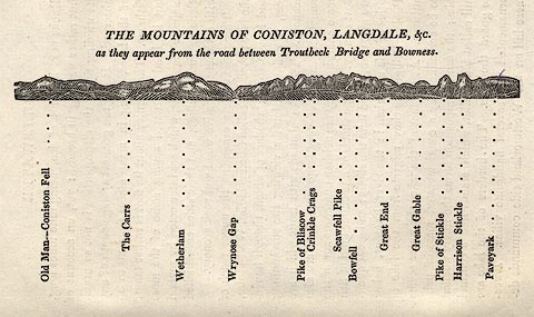 click to enlarge click to enlargeOT2E01.jpg Printed on p.7 of A Concise Description of the English Lakes, by Jonathan Otley, 5th edition, 1834. "THE MOUNTAINS OF CONISTON, LANGDALE, &c. as they appear from the road between Troutbeck Bridge and Bowness." Mountains in the view are listed:- "Old Man - Coniston Fell / The Carrs / Wetherlam / Wrynose Gap / Pike of Bliscow / Crinkle Crags / Scawfell Pike / Bowfell / Great End / Great Gable / Pike of Stickle / Harrison Stickle / Paveyark" item:- JandMN : 48.2 Image © see bottom of page |
|
|
|
||
| evidence:- | outline view:- Otley 1823 (5th edn 1834) |
|
| source data:- | Print, woodcut outline view, A Group of Mountains, seen from
Helvellyn, by Jonathan Otley, Keswick, Cumberland, 1830.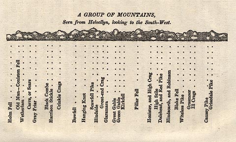 click to enlarge click to enlargeOT2E09.jpg Printed on p.63 of A Concise Description of the English Lakes, by Jonathan Otley, 5th edition, 1834. "A GROUP OF MOUNTAINS, Seen from Helvellyn, looking to the South-West." "Holm Fell / Old Man - Coniston Fell / Wetherlam / Carrs, or Scars / Gray Friar / Black Combe / Harrison Stickle / Crinkle Crags / Bowfell / Hanging Knot / Scawfell Pike / Hindside / Great-end Crag / Glaramara / Great Gable / Green Gable / Kirkfell / Pillar Fell / Honister, and High Crag / High Stile / Dalehead, and Red Pike / Hindscarth, and Robinson / Blake Fell / Witeless Pike / Grasmoor / Ill Crags / Causey Pike / Grisedale Pike" item:- JandMN : 48.10 Image © see bottom of page |
|
|
|
||
| evidence:- | descriptive text:- Otley 1823 (5th edn 1834) |
|
| source data:- | Guide book, A Concise Description of the English Lakes, the
mountains in their vicinity, and the roads by which they may be
visited, with remarks on the mineralogy and geology of the
district, by Jonathan Otley, published by the author, Keswick,
Cumberland now Cumbria, by J Richardson, London, and by Arthur
Foster, Kirkby Lonsdale, Cumbria, 1823; published 1823-49,
latterly as the Descriptive Guide to the English Lakes. goto source goto sourcePage 74:- "... Pike of Stickle, and Harrison Stickle, are by their peculiar form distinguished at a great distance. They afford some good views to the south east: but being encompassed on other sides by higher mountains, the prospect is somewhat limited. Harrison Stickle, the higher, is 2400 feet above the level of the sea: it is more easily ascended, and has the better prospect towards Rydal and Ambleside; ..." |
|
|
|
||
| evidence:- | outline view:- Martineau 1855 |
|
| source data:- | Print, engraving, outline view, Mountains on the West Side of Windermere, drawn by
L Aspland, engraved by W Banks, Edinburgh, published by John Garnett, Windermere,
Westmorland, and by Whittaker and Co, London, 1855.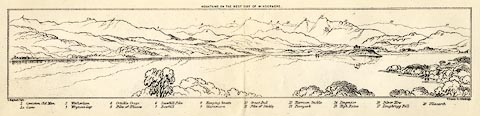 click to enlarge click to enlargeMNU102.jpg Folded in opposite p.7 in A Complete Guide to the English Lakes, by Harriet Martineau. "MOUNTAINS ON THE WEST SIDE OF WINDERMERE" "L Aspland Delt. / W Banks Sc Edinburgh." The view is captioned, numbers referring to mountains in the image:- "1 Coniston Old Man 1a Carrs 2 Wetherlam 3 Wrynose Gap 4 Crinkle Crags 5 Pike of Bliscow 6 Scawfell Pike 7 Bowfell 8 Hanging Knotts 9 Glaramara 10 Great End 11 Pike of Stickle 12 Harrison Stickle 13 Paveyark 14 Lingmoor 15 High Raise 16 Silver How 17 Loughrigg Fell 18 Ullscarth" item:- Armitt Library : A1159.2 Image © see bottom of page |
|
|
|
||
| evidence:- | outline view:- Martineau 1855 |
|
| source data:- | Print, engraving, outline view, Mountains seen a little beyond Rydal Mount, drawn
by L Aspland, engraved by W Banks, Edinburgh, published by John Garnett, Windermere,
Westmorland, and by Whittaker and Co, London, 1855.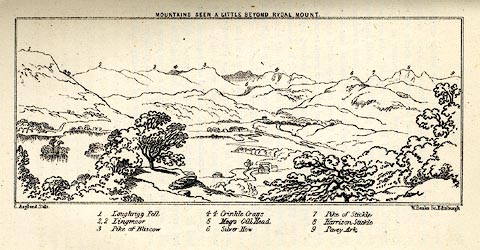 click to enlarge click to enlargeMNU109.jpg Opposite p.64 in A Complete Guide to the English Lakes, by Harriet Martineau. "MOUNTAINS SEEN A LITTLE BEYOND RYDAL MOUNT." "L Aspland Delt. / W Banks Sc Edinr." The view is captioned, numbers referring to mountains in the image:- "1 Loughrigg Fell, 2 Lingmoor, 3 Pike of Bliscow, 4 Crinkle Crags, 5 Meg's Gill Head, 6 Silver How, 7 Pike of Stickle, 8 Harrison Stickle, 9 Pavey Ark" item:- Armitt Library : A1159.9 Image © see bottom of page |
|
|
|
||
| evidence:- | old text:- Martineau 1855 item:- altitude, Harrison Stickle |
|
| source data:- | Guide book, A Complete Guide to the English Lakes, by Harriet
Martineau, published by John Garnett, Windermere, Westmorland,
and by Whittaker and Co, London, 1855; published 1855-76. goto source Page 149:- "..." "If the traveller means to ascend Harrison Stickle, (the higher of the Langdale Pikes,) it will be from this point [Milbeck?]. The summit of the Pike is 2,409 feet above the level of the sea. The height is not very great; but the view is interesting, from being unlike most others that can be obtained,- extending over the level country to the south and south-east, while commanded by the loftiest peaks of the district. ..." |
|
|
|
||
| evidence:- | old photograph:- Bell 1880s-1940s |
|
| source data:- | Photograph, black and white, Stickle Tarn and Harrison Stickle, Great Langdale, Westmorland,
by Herbert Bell, photographer, Ambleside, Westmorland, 1890s.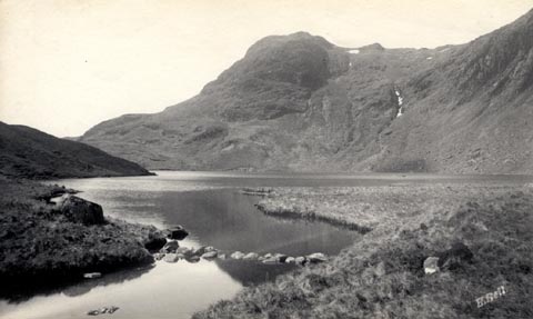 click to enlarge click to enlargeHB0642.jpg internegative at lower right:- "H. Bell" stamped on reverse:- "HERBERT BELL / Photographer / AMBLESIDE" item:- Armitt Library : ALPS305 Image © see bottom of page |
|
|
|
||
| evidence:- | outline view:- Black 1856 (23rd edn 1900) placename:- Harrison's Stickle |
|
| source data:- | Print, lithograph, Outline Views, Windermere - Mountains as seen from the North End
of Belle Isle, Windermere, and Mountains as seen from Biscay How, Bowness, by J Flintoft,
Keswick, Cumberland, engraved by R Mason, Edinburgh, Lothian, about 1900.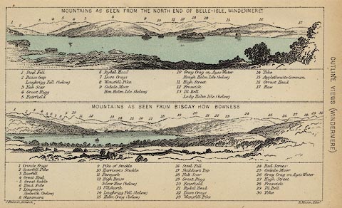 click to enlarge click to enlargeBC08E1.jpg "... 10 Harrison's Stickle ..." item:- JandMN : 37.4 Image © see bottom of page |
|
|
|
||
| evidence:- | outline view:- Black 1841 (3rd edn 1846) placename:- Harrison's Stickle |
|
| source data:- | Print, engraving, outline view, Mountains as seen from the North End of Belle Isle,
Windermere, and Mountains as seen from Bisket How, Bowness, by J Flintoft, Keswick,
Cumberland, engraved by R Mason, Edinburgh, about 1844.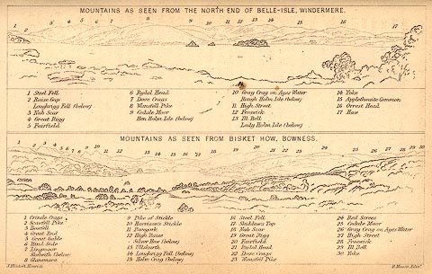 click to enlarge click to enlargeBC02E1.jpg "... 10 Harrison's Stickle ..." item:- JandMN : 32.3 Image © see bottom of page |
|
|
|
||
| evidence:- | outline view:- Tattersall 1836 placename:- Harrison Stickle |
|
| source data:- | Print, engraving, Great Langdale, Westmorland, drawn by George Tattersall, engraved
by W F Topham, published by Sherwood and Co, Paternoster Row, London, about 1836.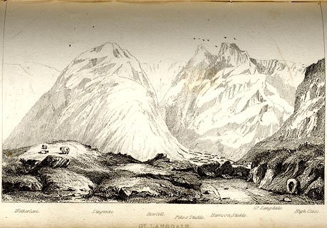 click to enlarge click to enlargeTAT112.jpg The print is captioned with mountain names and acts as an outline view. Tipped in opposite p.46 of The Lakes of England, by George Tattersall. printed at bottom:- "GT. LANGDALE." printed at bottom left to right:- "Wetherlam. / Lingmire. / Bowfell. / Pike o'Stickle. / Harrison Stickle. / Gt. Langdale. / High Close." item:- Armitt Library : A1204.13 Image © see bottom of page |
|
|
|
||
 BNR31.jpg (taken 22.5.2007) 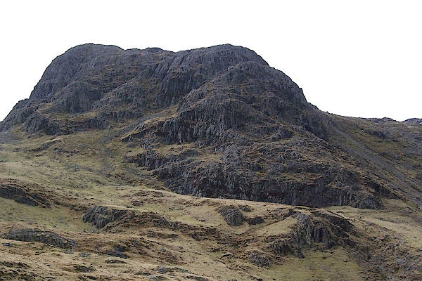 BSI96.jpg (taken 23.3.2010) |
||
|
|
||
Lakes Guides menu.