 Old Cumbria Gazetteer
 |
 |
|
| Helm Crag, Lakes | ||
| Helm Crag | ||
| civil parish:- | Lakes (formerly Westmorland) | |
| county:- | Cumbria | |
| locality type:- | hill | |
| coordinates:- | NY32520922 (etc) | |
| 1Km square:- | NY3209 | |
| 10Km square:- | NY30 | |
| altitude:- | 1299 feet | |
| altitude:- | 396m | |
|
|
||
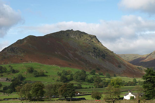 BRR43.jpg (taken 7.10.2009) 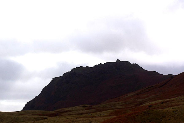 BLP97.jpg From the north. (taken 15.2.2006) |
||
|
|
||
| evidence:- | old map:- OS County Series (Wmd 18 16) placename:- Helm, The |
|
| source data:- | Maps, County Series maps of Great Britain, scales 6 and 25
inches to 1 mile, published by the Ordnance Survey, Southampton,
Hampshire, from about 1863 to 1948. |
|
|
|
||
| evidence:- | descriptive text:- West 1778 (11th edn 1821) |
|
| source data:- | Guide book, A Guide to the Lakes, by Thomas West, published by
William Pennington, Kendal, Cumbria once Westmorland, and in
London, 1778 to 1821. goto source goto sourceAddendum; Mr Gray's Journal, 1769 Page 210:- "..." "... Helm-crag, distinguished from its rugged neighbours, not so much by its height as by" goto sourcePage 211:- "the strange broken outline of its top, like some gigantic building demolished, and the stones that composed it flung across each other in wild confusion. ..." |
|
|
|
||
| evidence:- | old text:- Clarke 1787 placename:- Helm Cragg |
|
| source data:- | Guide book, A Survey of the Lakes of Cumberland, Westmorland,
and Lancashire, written and published by James Clarke, Penrith,
Cumberland, and in London etc, 1787; published 1787-93. goto source Page 120:- "..." "I shall here give an extract from Mr Gray's journal, (because I would wish to be thought impartial in every description.)" ""... Helm-Cragg; distinguished from its rugged neighbours, not so much by its height, as by the strange broken outlines of its top, like some gigantic building demolished, and the stones that composed it flung across in wild confusion. ..." |
|
|
|
||
| evidence:- | old print:- Farington 1789 |
|
| source data:- | Print, uncoloured engraving, Grasmere, Westmorland, drawn by Joseph Farington, engraved
by B T Pouncy, published by William Byrne, 79 Titchfield Street, London, 1785.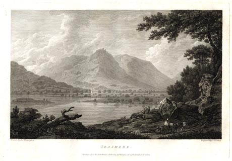 click to enlarge click to enlargeFA0305.jpg printed, bottom left, right, centre "Drawn by Josh. Farington / Engraved by B. T. Pouncy / GRASMERE. / Published as the Act directs, 1 Feb. 1785, by W. Byrne, No 79, Titchfield Str. London." item:- Armitt Library : A6668.5 Image © see bottom of page |
|
|
|
||
| evidence:- | old text:- Gents Mag |
|
| source data:- | Magazine, The Gentleman's Magazine or Monthly Intelligencer or
Historical Chronicle, published by Edward Cave under the
pseudonym Sylvanus Urban, and by other publishers, London,
monthly from 1731 to 1922. goto source Gentleman's Magazine 1792 p.882 "Aug. 18." "Mr. URBAN," "I AM lately returned from an excursion to the Lakes, and extract from my Ramble the following account of Helm Crag, a projecting mountain about five miles on the road between Ambleside and Keswick, and which has always been mentioned as a remarkable rock, though I believe it has never before been visited by tourists; a reason, Mr. Urban, that induces me to select it for the Gentleman's Magazine." "Yours, &c." "A RAMBLER." "July 29. We went up a narrow lane about half a mile from the church, which gave us a new view of Grassmere valley, with a perpetual water-fall, justly, from its force, called White-Churn Gill*; it seemed to rush from a crescent-heathed hill, and forms one of the most considerable brooks that supplies Grassmere." "The sun was hot. After a gentle ascent of about a mile we rested some minutes under a thick hawthorn, which we will call the foot of the crag. The projecting point of the first rise looked formidable, and not less so, to speak in plain English, from having a complete belly-full; however, when people are determined to overcome difficulties, time and circumstances are no obstructions." "We were covered from the wind, and it was so steep we were frequently obliged to stop when we met a narrow shelf; and, when we got to the first range of the hill, I was glad to throw myself down, panting for relief. The grass was slippery, which we guarded against by forcing our sticks as deep into the ground as we possibly could. And when we had gained the second height, I never remember meeting a more chearful relief than in finding we had got over that part of the hill which kept the wind from us; we were not only enlivened, but opened upon prospects which promised to repay our labour when we had surmounted it." "The pinnacle hanging over our right obliged us to take a sweep; and as we had the wind, and a near sight of the top, we found less trouble in this stage than in the others. We were exactly an hour from the hawthorn; which was not for its being a high hill, but the steepest in this part of the country, being seldom visited but by sheep, ravens, and foxes. Newton*, our guide, was never on it but once; and neither he nor any of the other guides remember its being visited by strangers." "But I must be alowed to rest myself a little before I say any thing of the prospects around us, and look with aweful pleasure at the sight." "We went upon the pinnacle, which had just room to hold two, from which I mark the views, but thought it prudent to have a less exalted rock in order to write them down." "The summit is covered with pieces of rock, that give it the appearance of a grand ruin occasioned by an earthquake, or a number of stones jumbled together after the mystical manner of the Druids. There is a deep fissure, two feet broad and twenty long, with a stone over one end of it, which gives it" "*A gill means a water-fall." "*Robert Newton, the guide, keeps a public-house in Grassmere, and may be safely recommended as a modest obliging man." |
|
|
|
||
| evidence:- | old text:- Gents Mag 1792 |
|
| source data:- | goto source Gentleman's Magazine 1792 p.883 "the look of a step over a mill stream. Although I am not versed in antiquities, I cannot help thinking this chasm resembles the kistvaens of the Druids, as described by the learned and indefatigable Grose, in his Preface, p.136. I wish some Antiquary would investigate this mountain. I think his fellow labourers would be obliged to him; and, at any rate, if he does not find sufficient to authenticate my surmise, he will have so delightful a command around him as may well re-pay him for his trouble, and, I trust, may induce him to think he has not taken his labour in vain. By dropping a pebble down a rent, you may hear it rebound a long time. One bending stone serves as a shelter for sheep, where we found a mushroom, the only one we saw in the North; and I even think this stone, from its bend, is part of a Cromlech of the Druids." "The circumference of the crag, including its mis-shapen points, may be a mile; and where there is any soil the grass is remarkably sweet. From this unfrequented point to the North-east we saw the whole of Windermere, Esthwaite water; and, by Grassmere lake being our point, they make a complete triangle, divided by rich pastures, &c. whilst the valley and its appendages, directly under us, seemed to contain every thing that can be beautiful in miniature." "We overlooked the Tarn*, whence White-Church Gill has its course, inclosed in the horse-shoe, whose sides are bespangled with smooth stones, occasioned by a thin sheet of water oozing over them, and an almost perpendicular sun." "We observed, over Helveylin and the grain†of Seat Sandal, a torrent of rain; whilst over Bowness, and to the South east, it was so partially collecting, the distance gave them the appearance of water-spouts. We imagined we had nothing to fear from any of them; it was clear over head, and in the quarter whence the wind blew. The guide had scarcley said so, ere we observed the clouds from Seat Sandal pushing against the wind, though they were considerably exhausted on those mountains. We were soon convinced of our ill-judging, and took shelter in the sheep-cove, which, by sitting, and bending, held us secure. This was too confined a situation; and, as the rain had somewhat ceased, the guide and I went about 150 yards down the hill. The rain increased, and wetted us to the skin; but we were amply re-paid by the most luminous sight I had ever beheld. I shall attempt to describe it." "The sun shone with such brilliancy through the slanting drops, they fell resembling a line of crystal as round as a finger, and they were intermixed with a spray as variegated as the rainbow. Newton, who has been all his life accustomed to mountains, allowed he never saw any thing like it before. Might it not be owing to the dark heath over the Tarn, and a partial shining of the sun over the crag?" "Too much rain had fallen to render the grass less slippery; we were obliged to traverse down the hill with the utmost caution, and, though not with so much difficulty as the acsent, with considerably more danger. When we opened the valley of Seat Sandal, we were surprised by a superb cataract, occasioned by the rain which fell whilst we were upon the summit. God forgive me! but I could not help wishing and expecting we should have a thunder storm." "Let the considerate mind contemplate the various sights that were presented to us in so short a time!" "A RAMBLER." "*A small piece of water." " †A grain, in the North, is meant for a valley." |
|
|
|
||
| evidence:- | old print:- Green 1814 (plate 21) item:- cattle |
|
| source data:- | Print, uncoloured soft ground etching, Grasmere from Town End, Grasmere, Westmorland,
by William Green, Ambleside, Westmorland, 1814.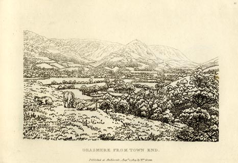 click to enlarge click to enlargeGN0921.jpg Plate 21 in Sixty Small Prints. printed at top right:- "21" printed at bottom:- "GRASMERE FROM TOWN END. / Published at Ambleside Augst. 1, 1814, by Wm. Green." item:- Armitt Library : A6656.21 Image © see bottom of page |
|
|
|
||
| evidence:- | old print:- Green 1814 (plate 21) item:- cattle |
|
| source data:- | Print, tinted soft ground etching, Grasmere from Town End, Grasmere, Westmorland,
by William Green, Ambleside, Westmorland, 1814.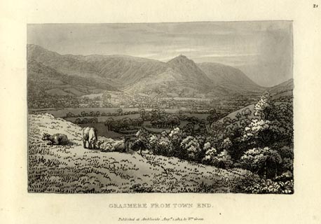 click to enlarge click to enlargeGN1021.jpg Plate 21 in Sixty Small Prints. printed at top right:- "21" printed at bottom:- "GRASMERE FROM TOWN END. / Published at Ambleside Augst. 1, 1814, by Wm. Green." item:- Armitt Library : A6653.21 Image © see bottom of page |
|
|
|
||
| evidence:- | old map:- Otley 1818 placename:- Helm |
|
| source data:- | Map, uncoloured engraving, The District of the Lakes,
Cumberland, Westmorland, and Lancashire, scale about 4 miles to
1 inch, by Jonathan Otley, 1818, engraved by J and G Menzies,
Edinburgh, Scotland, published by Jonathan Otley, Keswick,
Cumberland, et al, 1833. OT02NY30.jpg item:- JandMN : 48.1 Image © see bottom of page |
|
|
|
||
| evidence:- | old print:- Fielding and Walton 1821 (plate 21) placename:- Helm Crag |
|
| source data:- | Print, coloured aquatint, Grasmere Church and Helm Crag, Grasmere, Westmorland, drawn
by John Walton, published by R Ackermann, 101 Strand, London, 1821. click to enlarge click to enlargeFW0121.jpg St Oswald's Church. Tipped in opposite p.106 in A Picturesque Tour of the English Lakes. item:- Dove Cottage : 1993.R566.21 Image © see bottom of page |
|
|
|
||
| evidence:- | outline view:- Otley 1823 (8th edn 1849) placename:- Helm Crag |
|
| source data:- | Engraving, outline view of mountains, Grasmere from Red Bank Head, drawn by T Binns,
engraved by O Jewitt, opposite p.4 of A Descriptive Guide of the English Lakes, by
Jonathan Otley, 8th edition, 1849.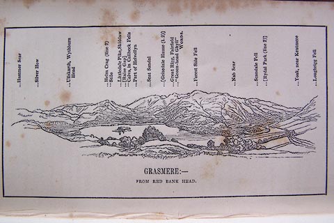 click to enlarge click to enlargeO80E04.jpg item:- Armitt Library : A1180.5 Image © see bottom of page |
|
|
|
||
| evidence:- | outline view:- Otley 1823 (5th edn 1834) |
|
| source data:- | Print, woodcut outline view, The Mountains of Grasmere and
Rydal, by Jonathan Otley, Keswick, Cumberland, 1830.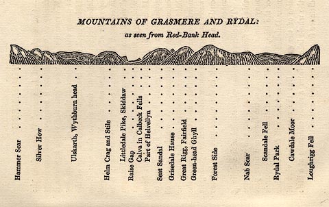 click to enlarge click to enlargeOT2E03.jpg Printed on p.15 of A Concise Description of the English Lakes, by Jonathan Otley, 5th edition, 1834. "MOUNTAINS OF GRASMERE AND RYDAL: as seen from Red-Bank Head." "Hammer Scar / Silver How / Ullskarth, Wythburn head / Helm Crag and Stile / Littledale Pike, Skiddaw / Raise Gap / Calva in Caldbeck Fells / Part of Helvellyn / Seat Sandal / Grisedale Hause / Great Rigg, Fairfield / Green-head Ghyll / Forest Side / Nab Scar / Scandale Fell / Rydal Park / Cawdale Moor / Loughrigg Fell" item:- JandMN : 48.4 Image © see bottom of page |
|
|
|
||
| evidence:- | descriptive text:- Otley 1823 (5th edn 1834) |
|
| source data:- | Guide book, A Concise Description of the English Lakes, the
mountains in their vicinity, and the roads by which they may be
visited, with remarks on the mineralogy and geology of the
district, by Jonathan Otley, published by the author, Keswick,
Cumberland now Cumbria, by J Richardson, London, and by Arthur
Foster, Kirkby Lonsdale, Cumbria, 1823; published 1823-49,
latterly as the Descriptive Guide to the English Lakes. goto source Page 109:- "... that admired vale. At the further end of which, between the branches of Easdale and Greenburn, stands Helm Crag, distinguished, not so much by its height, as by its summit of broken rocks, which Mr. Gray likens to 'some gigantic building demolished;' Mr. West to 'a mass of antediluvian ruins;' Mr. Green to the figures of a 'lion and a lamb;' and Mr. Wordsworth to an 'astrologer and old woman;' and the traveller who views it from Dunmail Raise, may think that a" goto sourcePage 110:- "mortar elevated for throwing shells into the valley, would be no unapt comparison. ..." |
|
|
|
||
| evidence:- | descriptive text:- Ford 1839 (3rd edn 1843) placename:- Helm Crag |
|
| source data:- | Guide book, A Description of Scenery in the Lake District, by
Rev William Ford, published by Charles Thurnam, Carlisle, by W
Edwards, 12 Ave Maria Lane, Charles Tilt, Fleet Street, William
Smith, 113 Fleet Street, London, by Currie and Bowman,
Newcastle, by Bancks and Co, Manchester, by Oliver and Boyd,
Edinburgh, and by Sinclair, Dumfries, 1839. goto source Page 164:- "... On the left, in passing up this valley [from Grasmere], the traveller will observe a lofty conical hill; it is called Helm Crag. The summit is composed of vast rocks, in whose forms fancy has discovered the resemblance of a lion and a lamb." |
|
|
|
||
| evidence:- | old drawing:- Aspland 1840s-60s |
|
| source data:- | Drawing, pencil, rocks on Helm Crag and Dunmail Raise, Westmorland, by Theophilus
Lindsey Aspland, 1857.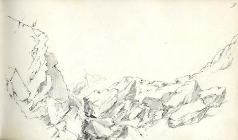 click to enlarge click to enlargeAS0511.jpg page number "9" item:- Armitt Library : 1958.389.11 Image © see bottom of page |
|
|
|
||
| evidence:- | old drawing:- Aspland 1840s-60s placename:- Helm Crag |
|
| source data:- | Drawing, pencil, Helm Crag, above Grasmere, Westmorland, by Theophilus Lindsey Aspland,
about 1849.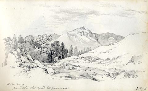 click to enlarge click to enlargeAS0129.jpg "Helm Crag / from the old road to Grasmere" item:- Armitt Library : 1958.487.29 Image © see bottom of page |
|
|
|
||
| evidence:- | old drawing:- Aspland 1840s-60s |
|
| source data:- | Drawing, pencil, three interpretation of the rocks atop Helm Crag, Westmorland, by
Theophilus Lindsey Aspland, about 1849.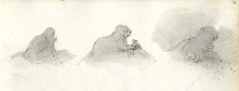 click to enlarge click to enlargeAS0130.jpg item:- Armitt Library : 1958.487.30 Image © see bottom of page |
|
|
|
||
| evidence:- | old map:- Garnett 1850s-60s H placename:- Helm Crag |
|
| source data:- | Map of the English Lakes, in Cumberland, Westmorland and
Lancashire, scale about 3.5 miles to 1 inch, published by John
Garnett, Windermere, Westmorland, 1850s-60s. GAR2NY30.jpg "Helm Crag" hill hachuring item:- JandMN : 82.1 Image © see bottom of page |
|
|
|
||
| evidence:- | old text:- Martineau 1855 item:- Lion and the Lamb |
|
| source data:- | Guide book, A Complete Guide to the English Lakes, by Harriet
Martineau, published by John Garnett, Windermere, Westmorland,
and by Whittaker and Co, London, 1855; published 1855-76. goto source Page 49:- "... The remarkable and beautiful hill behind the village is Helm Crag; and its rocky crest forms the group called the Lion and the Lamb. ..." |
|
|
|
||
| evidence:- | old photograph:- Bell 1880s-1940s |
|
| source data:- | Photograph, sepia, Helm Crag and the River Rothay, Grasmere, Westmorland, by Herbert
Bell, photographer, Ambleside, Westmorland, 1890s.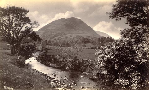 click to enlarge click to enlargeHB0571.jpg internegative at lower left:- "H. Bell" item:- Armitt Library : ALPS231 Image © see bottom of page |
|
|
|
||
| evidence:- | old map:- Burrow 1920s |
|
| source data:- | Road book, On the Road, Dunlop Pictorial Road Plans, volume V,
strip maps with parts in Westmorland, Cumberland etc, irregular
scale about 1.5 miles to 1 inch, by E J Burrow and Co,
Cheltenham, Gloucestershire, 1920s. EJB3Vg39.jpg item:- private collection : 17 Image © see bottom of page |
|
|
|
||
| evidence:- | old print:- Robertson 1911 placename:- Helm Crag |
|
| source data:- | Print, lithograph? Helm Crag, Grasmere, from a watercolour by Arthur Tucker, published
by Chatto and Windus, London, 1911.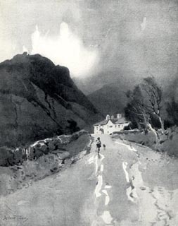 click to enlarge click to enlargeRSN139.jpg Tipped in opposite p.264 of Wordsworthshire by Eric Robertson. printed at bottom:- "HELM CRAG, GRASMERE" signed at painting lower left:- "Arthur Tucker" item:- JandMN : 197.43 Image © see bottom of page |
|
|
|
||
| evidence:- | old print:- |
|
| source data:- | Print, chromolithograph, Grasmere, Westmorland, published by T Nelson and Sons, London,
1900s?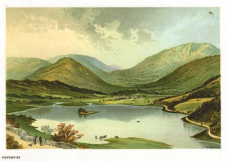 click to enlarge click to enlargePR0162.jpg From a set of prints, The Scenery of the English Lakes printed at lower right:- "T. NELSON &SONS" printed at bottom left:- "GRASMERE" item:- Dove Cottage : 2008.107.162 Image © see bottom of page |
|
|
|
||
| evidence:- | outline view:- Black 1856 (23rd edn 1900) placename:- Helm Crag |
|
| source data:- | Print, lithograph, Outline Views, Windermere - Mountains as seen from the North End
of Belle Isle, Windermere, and Mountains as seen from Biscay How, Bowness, by J Flintoft,
Keswick, Cumberland, engraved by R Mason, Edinburgh, Lothian, about 1900.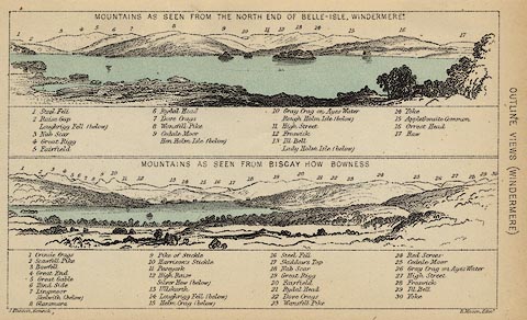 click to enlarge click to enlargeBC08E1.jpg "... 15 Helm Crag ..." item:- JandMN : 37.4 Image © see bottom of page |
|
|
|
||
| evidence:- | outline view:- Black 1856 (23rd edn 1900) placename:- Helm Crag |
|
| source data:- | Print, lithograph, Outline Views, Grasmere and Coniston - Mountains as seen from Redbank,
Grasmere, and Mountains as seen a little beyond Tent Lodge on the Road from Coniston
to Ulverstone, by J Flintoft, Keswick, Cumberland, engraved by R Mason, Edinburgh,
Lothian, about 1900.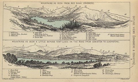 click to enlarge click to enlargeBC08E3.jpg "... Helm Crag ..." item:- JandMN : 37.12 Image © see bottom of page |
|
|
|
||
| evidence:- | old print:- Pyne 1853 |
|
| source data:- | Grasmere from Loughrigg Fell drawn by James Barker Pyne, 1848-1853, lithographed by
T Picken, 1859.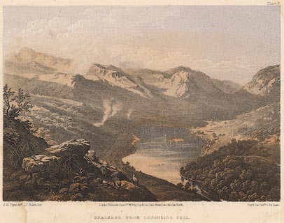 click to enlarge click to enlargePY08.jpg "Grasmere from Loughrigg Fell" item:- JandMN : 97.9 Image © see bottom of page |
|
|
|
||
| evidence:- | old map:- Hudson 1842 (4th edn 1853) |
|
| source data:- | Map, uncoloured engraving, Eight Miles round Grasmere, engraved
by W Banks, Edinburgh, published by John Hudson, Kendal,
Westmorland, 1853.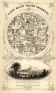 click to enlarge click to enlargeHUD1M1.jpg Map, uncoloured engraving, Eight Miles round Grasmere, engraved by W Banks, Edinburgh, published by John Hudson, Kendal, Westmorland, 1853. Circular map, with a vignette view of Grasmere lake and Helm Crag below. Tipped in opp p.58 in A Complete Guide to the Lakes, edited John Hudson. printed at top:- "EIGHT MILES ROUND GRASMERE." printed at bottom:- "W. Banks, sc. Edinr." item:- JandMN : 327.4 Image © see bottom of page |
|
|
|
||
| evidence:- | old print:- Harwood 1842 |
|
| source data:- | Print, uncoloured engraving, Grasmere, Westmorland, engraved and published by John
Harwood, 26 Fenchurch Street, London, 1845. click to enlarge click to enlargeHRW206.jpg printed at bottom left, right, centre:- "London, J. Harwood, 26, Fenchurch Street. / No.599. Aug. 6, 1845. / Grasmere." item:- JandMN : 166.6 Image © see bottom of page |
|
|
|
||
| evidence:- | outline view:- Black 1841 (3rd edn 1846) placename:- Helm Crag |
|
| source data:- | Print, engraving, outline view, Mountains as seen from the North End of Belle Isle,
Windermere, and Mountains as seen from Bisket How, Bowness, by J Flintoft, Keswick,
Cumberland, engraved by R Mason, Edinburgh, about 1844.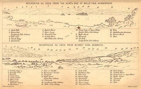 click to enlarge click to enlargeBC02E1.jpg "... 15 Helm Crag ..." item:- JandMN : 32.3 Image © see bottom of page |
|
|
|
||
| evidence:- | outline view:- Black 1841 (3rd edn 1846) placename:- Helm Crag |
|
| source data:- | Print, engraving, outline view, Mountains as seen from Red Bank, Grasmere, and Mountains
as seen a little beyond Tent-Lodge on the Road from Coniston to Ulverston, by J Flintoft,
Keswick, Cumberland, engraved by R Mason, Edinburgh, Lothian, about 1846.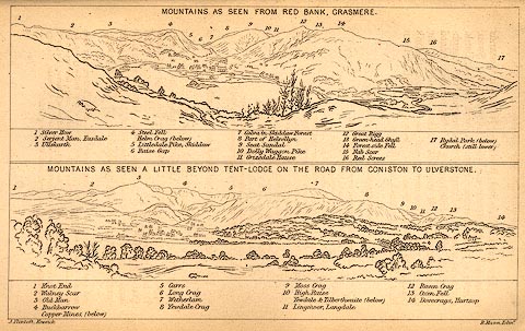 click to enlarge click to enlargeBC02E3.jpg "... Helm Crag ..." item:- JandMN : 32.5 Image © see bottom of page |
|
|
|
||
| evidence:- | outline view:- Tattersall 1836 (version 1869) placename:- Helm Crag |
|
| source data:- | Print, hand coloured, Grasmere, from Loughrigg Fell, Westmorland, drawn by George
Tattersall, 1836, engraved by W F Topham, published by T J Allman, 463 Oxford Street,
London, 1869.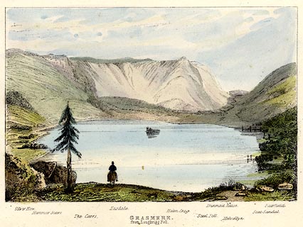 click to enlarge click to enlargeTAT205.jpg Included in The Lakes of England, by W F Topham. printed at bottom:- "GRASMERE, / from Loughrigg Fell." printed at bottom:- "Silver How. / Hammar Scarr. / The Carrs. / Easdale. / Helm Crag. / Steel Fell. / Dunmail Hause. / Helvellyn. / Seat Sandal. / Fairfield." item:- Armitt Library : A1067.5 Image © see bottom of page |
|
|
|
||
| evidence:- | old print:- Rose 1832-35 |
|
| source data:- | Print, engraving, Grasmere Lake and Village, by George Pickering, engraved by C Mottram,1833.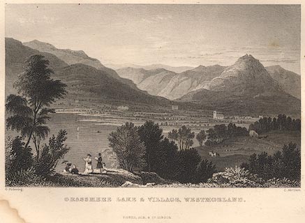 click to enlarge click to enlargeR156.jpg item:- JandMN : 66.12 Image © see bottom of page |
|
|
|
||
| evidence:- | old print:- Farington 1789 (plate 5) placename:- Helme Crag |
|
| source data:- | Print, engraving, Grasmere, Lakes, Cumbria, painted by Joseph Farington, engraved
by B T Pouncy, published by W Byrne, 69 Titchfield Street, London, 1785.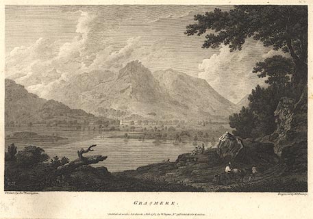 click to enlarge click to enlargeBMZ04.jpg Grasmere lake, Grasmere and St Oswald's Church, and Helm Crag etc, in the background. Plate 5 from Views of the Lakes, &c, in Cumberland and Westmorland, published 1789. item:- Dove Cottage : Lowther.4 Image © see bottom of page |
|
|
|
||
| evidence:- | old print:- Green 1809 placename:- Helme Crag |
|
| source data:- | Print, soft ground etching, Grasmere, Westmorland, by William Green, published by
William Green, Ambleside, Westmorland, and Longman, Hurst, Rees and Orme, Paternoster
Row, London, 1809.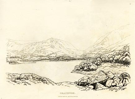 click to enlarge click to enlargeGN0351.jpg Plate 51 in Seventy Eight Studies from Nature. printed in introductory pages to set of prints:- "Number 51. This view of the lake and vale of Grasmere is from the side of Loughrigg Fell, below the road to Langdale Chapel from Ambleside. ... Helme Crag, a mountain of good figure from some parts of the valley, is seen above the church; ..." printed at bottom:- "GRASMERE. / Published Ambleside, Augst. 1st. 1809, by W. Green." item:- Armitt Library : A6637.51 Image © see bottom of page |
|
|
|
||
Lakes Guides menu.