 Old Cumbria Gazetteer
 |
 |
|
| Hewthwaite Hall, Setmurthy | ||
| Hewthwaite Hall | ||
| civil parish:- | Setmurthy (formerly Cumberland) | |
| county:- | Cumbria | |
| locality type:- | buildings | |
| coordinates:- | NY15233283 | |
| 1Km square:- | NY1532 | |
| 10Km square:- | NY13 | |
|
|
||
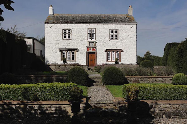 CEH92.jpg (taken 2015) courtesy of Ed Hughes 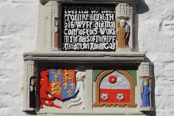 CEH93.jpg Date stone, coat of arms, etc above the door:- "[IOHN SWYNBUN / ESQUIRE &ELSABTH / HIS WYFE DID MAI / COSTE IOF THIS WORK / IN THE DAIS OF THER LYF / ANO DOM 1581 ANO REG 23]" (taken 2015) courtesy of Ed Hughes |
||
|
|
||
| evidence:- | old map:- OS County Series (Cmd 46 13) placename:- Hewthwaite Hall |
|
| source data:- | Maps, County Series maps of Great Britain, scales 6 and 25
inches to 1 mile, published by the Ordnance Survey, Southampton,
Hampshire, from about 1863 to 1948. |
|
|
|
||
| evidence:- | old map:- Saxton 1579 placename:- Huthwate |
|
| source data:- | Map, hand coloured engraving, Westmorlandiae et Cumberlandiae Comitatus ie Westmorland
and Cumberland, scale about 5 miles to 1 inch, by Christopher Saxton, London, engraved
by Augustinus Ryther, 1576, published 1579-1645.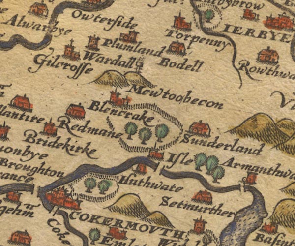 Sax9NY13.jpg Tower, symbol for a house, hall, tower, etc. "Huthwate" item:- private collection : 2 Image © see bottom of page |
|
|
|
||
| evidence:- | old map:- Mercator 1595 (edn?) placename:- Huthwate |
|
| source data:- | Map, hand coloured engraving, Northumbria, Cumberlandia, et
Dunelmensis Episcopatus, ie Northumberland, Cumberland and
Durham etc, scale about 6.5 miles to 1 inch, by Gerard Mercator,
Duisberg, Germany, about 1595.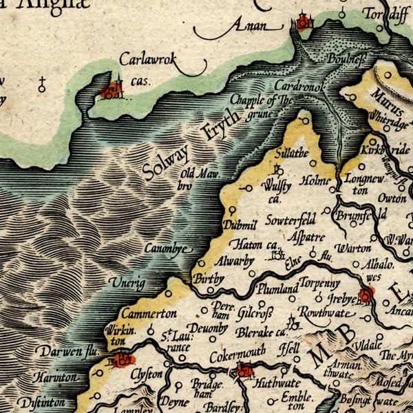 MER8CumB.jpg "Huthwate" circle item:- JandMN : 169 Image © see bottom of page |
|
|
|
||
| evidence:- | old map:- Speed 1611 (Cmd) placename:- Huthwate |
|
| source data:- | Map, hand coloured engraving, Cumberland and the Ancient Citie
Carlile Described, scale about 4 miles to 1 inch, by John Speed,
1610, published by J Sudbury and George Humble, Popes Head
Alley, London, 1611-12.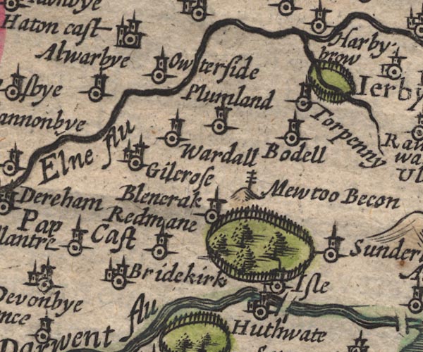 SP11NY13.jpg "Huthwate" circle, tower item:- private collection : 16 Image © see bottom of page |
|
|
|
||
| evidence:- | possibly table of distances:- Simons 1635 placename:- Huthwate |
|
| source data:- | Table of distances, uncoloured engraving, Cumberland, with a
thumbnail map, scale about 41 miles to 1 inch, by Mathew Simons,
published in A Direction for the English Traviller, 1635.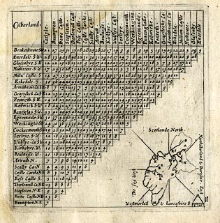 click to enlarge click to enlargeSIM4.jpg "Huthwate S.W." and tabulated distances item:- private collection : 50.11 Image © see bottom of page |
|
|
|
||
| evidence:- | old map:- Jansson 1646 placename:- Huthwate |
|
| source data:- | Map, hand coloured engraving, Cumbria and Westmoria, ie
Cumberland and Westmorland, scale about 3.5 miles to 1 inch, by
John Jansson, Amsterdam, Netherlands, 1646.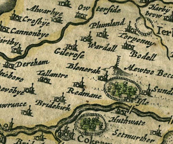 JAN3NY13.jpg "Huthwate" Buildings and tower. item:- JandMN : 88 Image © see bottom of page |
|
|
|
||
| evidence:- | old map:- Morden 1695 (Cmd) placename:- Huthwaite |
|
| source data:- | Map, uncoloured engraving, Cumberland, scale about 4 miles to 1
inch, by Robert Morden, 1695, published by Abel Swale, the
Unicorn, St Paul's Churchyard, Awnsham, and John Churchill, the
Black Swan, Paternoster Row, London, 1695-1715.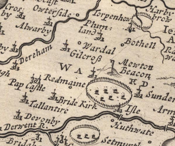 MD12NY13.jpg "Huthwaite" Circle. item:- JandMN : 90 Image © see bottom of page |
|
|
|
||
| evidence:- | old map:- Bowen and Kitchin 1760 placename:- Huthwate |
|
| source data:- | Map, hand coloured engraving, A New Map of the Counties of
Cumberland and Westmoreland Divided into their Respective Wards,
scale about 4 miles to 1 inch, by Emanuel Bowen and Thomas
Kitchin et al, published by T Bowles, Robert Sayer, and John
Bowles, London, 1760.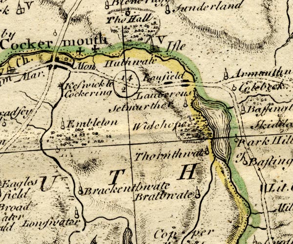 BO18NY12.jpg "Huthwate" no symbol item:- Armitt Library : 2008.14.10 Image © see bottom of page |
|
|
|
||
| evidence:- | old map:- Donald 1774 (Cmd) placename:- Heauthwaite Hall |
|
| source data:- | Map, hand coloured engraving, 3x2 sheets, The County of Cumberland, scale about 1
inch to 1 mile, by Thomas Donald, engraved and published by Joseph Hodskinson, 29
Arundel Street, Strand, London, 1774.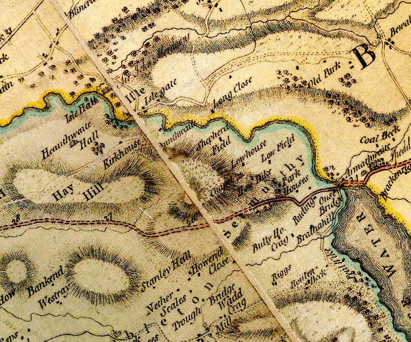 D4NY13SE.jpg "Heauthwaite Hall" house item:- Carlisle Library : Map 2 Image © Carlisle Library |
|
|
|
||
| evidence:- | road book:- Cary 1798 (2nd edn 1802) placename:- Hauthwaite Hall |
|
| source data:- | Road book, itineraries, Cary's New Itinerary, by John Cary, 181
Strand, London, 2nd edn 1802. goto source goto source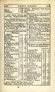 click to enlarge click to enlargeC38557.jpg page 557-558 "Between Ouse Bridge and Cockermouth, on r. is Hauthwaite Hall, Joshua Lucock, Esq." item:- JandMN : 228.2 Image © see bottom of page |
|
|
|
||
| evidence:- | old print:- Taylor 1892 placename:- Huthwaite Hall item:- door; coat of arms; date stone (1581) |
|
| source data:- | Print, halftone photograph, Doorway, Huthwaite Hall - Hewthwaite Hall, Setmurthy,
Cumberland, published for the Cumberland and Westmorland Antiquarian and Archaeological
Society, by Titus Wilson, Kendal, Westmorland, and by Charles Thurnam and Sons, Carlisle,
Cumberland, 1892.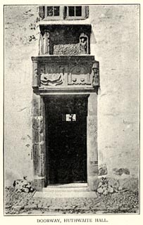 click to enlarge click to enlargeTY5075.jpg Inscription '[John Swynburn / Esquire &Elizabeth / his Wyfe did make / cost of this work / in the dais of ther Lyfe / Ano Dmi 1581 Ano Rae 23]'. Blazons of the two shields given by Taylor - quarterly 1. and 4. three fleur de lys 1 and 2 2. and 3. three lions passant regardant - inverted, three cinquefoils 1 and 2 Tipped in opposite p.331 of The Old Manorial Halls of Cumberland and Westmorland, by Michael Waistell Taylor. item:- Armitt Library : A785.75 Image © see bottom of page |
|
|
|
||
| evidence:- | old print:- Taylor 1892 placename:- Huthwaite Hall item:- window |
|
| source data:- | Print, halftone photograph, Staircase Window, Huthwaite Hall - Hewthwaite Hall, Setmurthy,
Cumberland, published for the Cumberland and Westmorland Antiquarian and Archaeological
Society, by Titus Wilson, Kendal, Westmorland, and by Charles Thurnam and Sons, Carlisle,
Cumberland, 1892.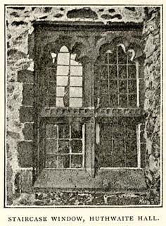 click to enlarge click to enlargeTY5076.jpg On p.333 of The Old Manorial Halls of Cumberland and Westmorland, by Michael Waistell Taylor. item:- Armitt Library : A785.76 Image © see bottom of page |
|
|
|
||
| evidence:- | database:- Listed Buildings 2010 placename:- Hewthwaite Hall item:- coat of arms; date stone (1581) |
|
| source data:- | courtesy of English Heritage "HEWTHWAITE HALL / / / SETMURTHY / ALLERDALE / CUMBRIA / II[star] / 72735 / NY1523832836" |
|
|
|
||
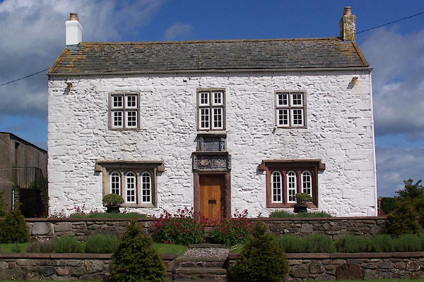 BNR56.jpg (taken 25.5.2007) 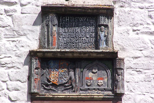 BNR57.jpg Date stone, coat of arms, etc above the door. (taken 25.5.2007) |
||
|
|
||
| hearsay:- |
Incribed on a date stone:- |
|
| "[Iohn Swynburn esquire &elsabth his wyfe did make coste of this Work in the dais of
ther lyfe Ano Do~ 1581 Ano Reg 23]" |
||
| Another authority gives it as:- |
||
| "[John Swynburn esquire and Elisabeth his wyfe / Did mak coste of this work in the
dais of ther lyf / Ano Dom 1581 Ano Reg 23]" |
||
| 1581 is the 23rd year of Elizabeth I, who came to the throne in 1558. Notice the dragon
supporter with royal coat of arms. The coat of arms on the right of the date stone
is inverted, and bears three cinquefoils. |
||
|
|
||
| notes:- |
hall and site of supposed tower |
|
| Perriam, D R &Robinson, J: 1998: Medieval Fortified Buildings of Cumbria: CWAAS::
ISBN 1 873124 23 6; plan |
||
|
|
||
Lakes Guides menu.