 Old Cumbria Gazetteer
 |
 |
|
| Howgill Castle, Milburn | ||
| out of sight | ||
| Howgill Castle | ||
| civil parish:- | Milburn (formerly Westmorland) | |
| county:- | Cumbria | |
| locality type:- | buildings | |
| coordinates:- | NY66572930 | |
| 1Km square:- | NY6629 | |
| 10Km square:- | NY62 | |
|
|
||
| evidence:- | old map:- OS County Series (Wmd 5 10) placename:- Howgill Castle |
|
| source data:- | Maps, County Series maps of Great Britain, scales 6 and 25
inches to 1 mile, published by the Ordnance Survey, Southampton,
Hampshire, from about 1863 to 1948. "Howgill Castle" |
|
|
|
||
| evidence:- | old map:- Saxton 1579 placename:- Howgill Castle |
|
| source data:- | Map, hand coloured engraving, Westmorlandiae et Cumberlandiae Comitatus ie Westmorland
and Cumberland, scale about 5 miles to 1 inch, by Christopher Saxton, London, engraved
by Augustinus Ryther, 1576, published 1579-1645.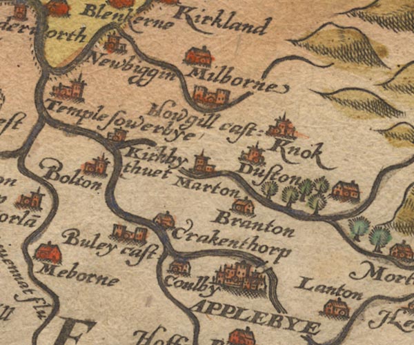 Sax9NY62.jpg Building with two towers, symbol for a castle. "Howgill cast:" item:- private collection : 2 Image © see bottom of page |
|
|
|
||
| evidence:- | old map:- Mercator 1595 (edn?) placename:- Howgill Castle |
|
| source data:- | Map, hand coloured engraving, Westmorlandia, Lancastria, Cestria
etc, ie Westmorland, Lancashire, Cheshire etc, scale about 10.5
miles to 1 inch, by Gerard Mercator, Duisberg, Germany, 1595,
edition 1613-16. MER5WmdA.jpg "Howgill ca." circle, building/s, tower, tinted red item:- Armitt Library : 2008.14.3 Image © see bottom of page |
|
|
|
||
| evidence:- | old map:- Speed 1611 (Wmd) placename:- Howgill Castle |
|
| source data:- | Map, hand coloured engraving, The Countie Westmorland and
Kendale the Cheif Towne, scale about 2.5 miles to 1 inch, by
John Speed, 1610, published by George Humble, Popes Head Alley,
London, 1611-12.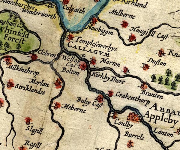 SP14NY62.jpg "Howgill Cast" circle, towers item:- Armitt Library : 2008.14.5 Image © see bottom of page |
|
|
|
||
| evidence:- | old map:- Jansson 1646 placename:- Howgill Castle |
|
| source data:- | Map, hand coloured engraving, Cumbria and Westmoria, ie
Cumberland and Westmorland, scale about 3.5 miles to 1 inch, by
John Jansson, Amsterdam, Netherlands, 1646.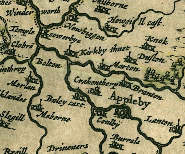 JAN3NY62.jpg "Howgill cast." Buildings and tower with flag. item:- JandMN : 88 Image © see bottom of page |
|
|
|
||
| evidence:- | hearth tax returns:- Hearth Tax 1675 placename:- Howgill Castle |
|
| source data:- | Records, hearth tax survey returns, Westmorland, 1674/75. "Howgill Castle" in "Millburne" |
|
|
|
||
| evidence:- | old map:- Seller 1694 (Wmd) placename:- Howgill Castle |
|
| source data:- | Map, hand coloured engraving, Westmorland, scale about 8 miles
to 1 inch, by John Seller, 1694. click to enlarge click to enlargeSEL7.jpg "Howgill Cast" circle; castle item:- Dove Cottage : 2007.38.87 Image © see bottom of page |
|
|
|
||
| evidence:- | old map:- Morden 1695 (Cmd) placename:- Howgill Castle |
|
| source data:- | Map, uncoloured engraving, Cumberland, scale about 4 miles to 1
inch, by Robert Morden, 1695, published by Abel Swale, the
Unicorn, St Paul's Churchyard, Awnsham, and John Churchill, the
Black Swan, Paternoster Row, London, 1695-1715.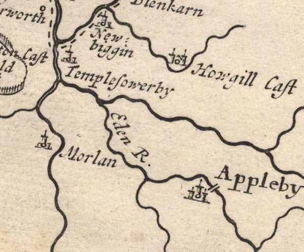 MD12NY62.jpg "Howgill Cast" Circle, building with two towers. item:- JandMN : 90 Image © see bottom of page |
|
|
|
||
| evidence:- | old map:- Morden 1695 (Wmd) placename:- Howgill Castle |
|
| source data:- | Map, hand coloured engraving, Westmorland, scale about 2.5 miles to 1 inch, by Robert
Morden, published by Abel Swale, the Unicorn, St Paul's Churchyard, Awnsham, and John
Churchill, the Black Swan, Paternoster Row, London, 1695. MD10NY62.jpg "Howgill Castle" Circle, tower. item:- JandMN : 24 Image © see bottom of page |
|
|
|
||
| evidence:- | old map:- Badeslade 1742 placename:- Howgin Castle |
|
| source data:- | Map, uncoloured engraving, A Map of Westmorland North from
London, scale about 10 miles to 1 inch, with descriptive text,
by Thomas Badeslade, London, engraved and published by William
Henry Toms, Union Court, Holborn, London, 1742. click to enlarge click to enlargeBD12.jpg "Howgin C." circle, italic lowercase text; village, hamlet or locality item:- Dove Cottage : 2007.38.62 Image © see bottom of page |
|
|
|
||
| evidence:- | old map:- Simpson 1746 map (Wmd) placename:- Howgin Castle |
|
| source data:- | Map, uncoloured engraving, Westmorland, scale about 8 miles to 1
inch, printed by R Walker, Fleet Lane, London, 1746. SMP2NYR.jpg "Howgin C." Building. item:- Dove Cottage : 2007.38.59 Image © see bottom of page |
|
|
|
||
| evidence:- | old map:- Bowen and Kitchin 1760 placename:- Howgil Castle |
|
| source data:- | Map, hand coloured engraving, A New Map of the Counties of
Cumberland and Westmoreland Divided into their Respective Wards,
scale about 4 miles to 1 inch, by Emanuel Bowen and Thomas
Kitchin et al, published by T Bowles, Robert Sayer, and John
Bowles, London, 1760. BO18NY62.jpg "Howgil Cas." circle and ?line item:- Armitt Library : 2008.14.10 Image © see bottom of page |
|
|
|
||
| evidence:- | old map:- Jefferys 1770 (Wmd) placename:- Hougil Castle |
|
| source data:- | Map, 4 sheets, The County of Westmoreland, scale 1 inch to 1
mile, surveyed 1768, and engraved and published by Thomas
Jefferys, London, 1770.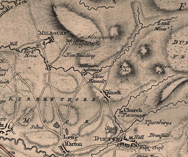 J5NY62NE.jpg "Hougil Castle / Gen. Honeywood" castle and avenue of trees item:- National Library of Scotland : EME.s.47 Image © National Library of Scotland |
|
|
|
||
| evidence:- | old text:- Camden 1789 (Gough Additions) placename:- Howgill Castle |
|
| source data:- | Book, Britannia, or A Chorographical Description of the Flourishing Kingdoms of England,
Scotland, and Ireland, by William Camden, 1586, translated from the 1607 Latin edition
by Richard Gough, published London, 1789. Camden 1789  goto source goto sourcePage 159:- "..." "Howgill castle is the mansion of Milburne manor. Some of its walls are ten feet and an half thick, and under it are great arched vaults. ..." |
|
|
|
||
| evidence:- | old map:- Cary 1789 (edn 1805) placename:- Hough Castle |
|
| source data:- | Map, uncoloured engraving, Westmoreland, scale about 2.5 miles
to 1 inch, by John Cary, London, 1789; edition 1805.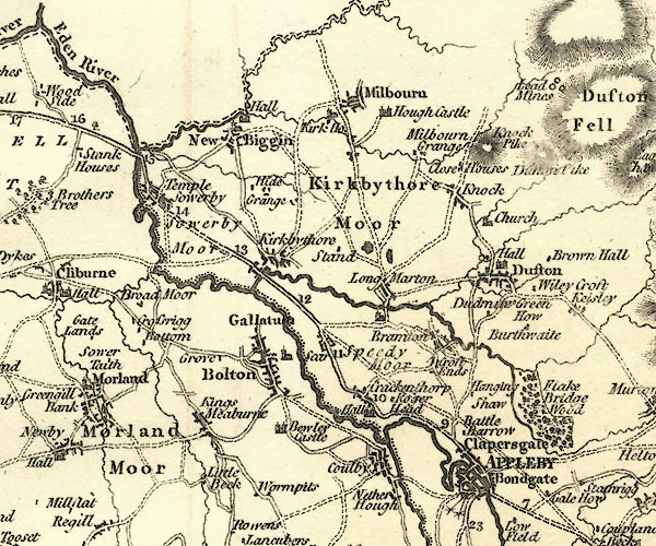 CY24NY62.jpg "Hough Castle" house symbol; castle item:- JandMN : 129 Image © see bottom of page |
|
|
|
||
| evidence:- | old photograph:- Bell 1880s-1940s placename:- Howgill Castle |
|
| source data:- | Photograph, Howgill Castle, Milburn, Westmorland, by Herbert Bell, photographer, Ambleside,
Westmorland, 1897.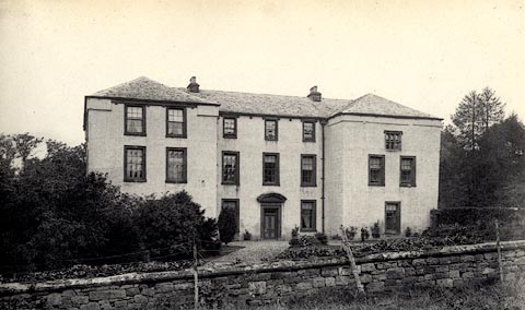 click to enlarge click to enlargeHB0043.jpg Vol.1 no.43 in an album, Examples of Early Domestic and Military Architecture in Westmorland, assembled 1910. ms at bottom:- "43. Howgill Castle. Kirkby Thore. E." item:- Armitt Library : 1958.3165.43 Image © see bottom of page |
|
|
|
||
| evidence:- | old photograph:- Bell 1880s-1940s placename:- Howgill Castle item:- gate piers |
|
| source data:- | Photograph, Howgill Castle, Gateway, Milburn, Westmorland, by Herbert Bell, photographer,
Ambleside, Westmorland, 1897.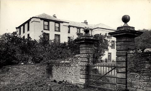 click to enlarge click to enlargeHB0044.jpg Vol.1 no.44 in an album, Examples of Early Domestic and Military Architecture in Westmorland, assembled 1910. ms at bottom:- "44. Howgill Castle. Kirkby Thore. E." item:- Armitt Library : 1958.3165.44 Image © see bottom of page |
|
|
|
||
| evidence:- | old photograph:- Bell 1880s-1940s placename:- Howgill Castle item:- fireplace; chair; fireback |
|
| source data:- | Photograph, Howgill Castle, Stone Chimneypiece, Milburn, Westmorland, by Herbert Bell,
photographer, Ambleside, Westmorland, 1897.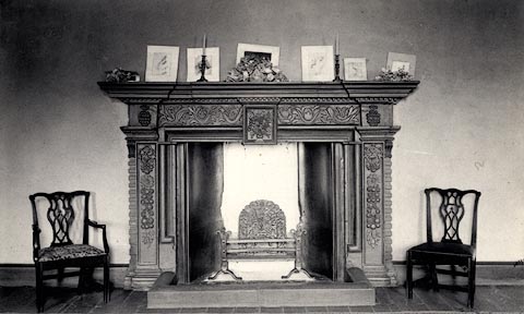 click to enlarge click to enlargeHB0045.jpg Vol.1 no.45 in an album, Examples of Early Domestic and Military Architecture in Westmorland, assembled 1910. ms at bottom:- "45. Howgill Castle, Stone Chimney-piece. Kirkby Thore. E." item:- Armitt Library : 1958.3165.45 Image © see bottom of page |
|
|
|
||
| evidence:- | old print:- Taylor 1892 placename:- Howgill Castle |
|
| source data:- | Print, plan of Howgill Castle, Milburn, Westmorland, published for the Cumberland
and Westmorland Antiquarian and Archaeological Society, by Titus Wilson, Kendal, Westmorland,
and by Charles Thurnam and Sons, Carlisle, Cumberland, 1892.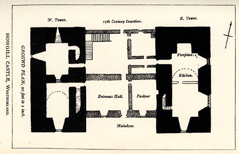 click to enlarge click to enlargeTY5023.jpg Tipped in opposite p.142 of The Old Manorial Halls of Cumberland and Westmorland, by Michael Waistell Taylor. item:- Armitt Library : A785.23 Image © see bottom of page |
|
|
|
||
| evidence:- | old print:- Curwen 1913 placename:- Howgill Castle item:- Carnarvon arch; arch; trefoil arch |
|
| source data:- | Print, halftone photograph, Howgill Castle, stepped trefoil arches, Milburn, Westmorland,
published for the Cumberland and Westmorland Antiquarian and Archaeological Society
by Titus Wilson, Kendal, Westmorland, 1913.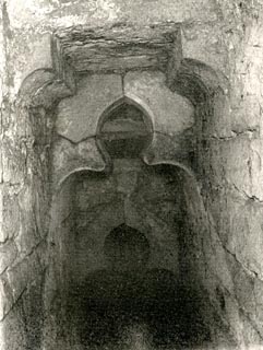 click to enlarge click to enlargeCW0153.jpg Tipped in opposite p.281 of The Castles and Fortified Towers of Cumberland, Westmorland, and Lancashire North of the Sands, by John F Curwen. printed at lower centre:- "HOWGILL CASTLE. / Showing stepped trefoil Arches in the thickness of / the North Wall." item:- Armitt Library : A782.53 Image © see bottom of page |
|
|
|
||
| evidence:- | site plan:- Curwen 1913 placename:- Howgill Castle |
|
| source data:- | Site plan, lithograph, Howgill Castle, Milburn, Westmorland, scale about 1 to 260,
published for the Cumberland and Westmorland Antiquarian and Archaeological Society
by Titus Wilson, Kendal, Westmorland, 1913.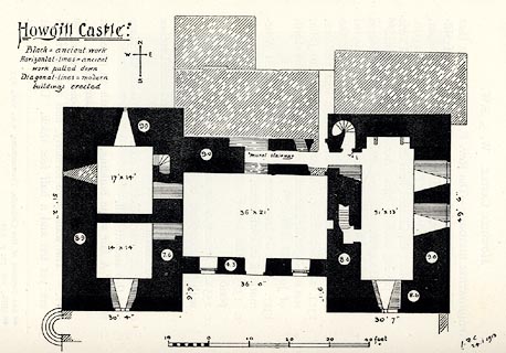 click to enlarge click to enlargeCW0154.jpg On p.282 of The Castles and Fortified Towers of Cumberland, Westmorland, and Lancashire North of the Sands, by John F Curwen. printed at upper left:- "Howgill Castle" printed at lower right:- "J. F. C. / 24.i.1913" item:- Armitt Library : A782.54 Image © see bottom of page |
|
|
|
||
| evidence:- | site plan:- Historical Monuments 1936 placename:- Howgill Castle |
|
| source data:- | Site plan, uncoloured lithograph, Howgill Castle, Milburn, Westmorland, scale about
1 to 380, published by Royal Commission on Historical Monuments England, London, 1936.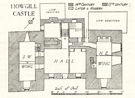 click to enlarge click to enlargeHMW106.jpg On p.174 of the Inventory of the Historical Monuments in Westmorland. printed, upper left "HOWGILL / CASTLE" RCHME no. Wmd, Milburn 3 item:- Armitt Library : A745.107 Image © see bottom of page |
|
|
|
||
| evidence:- | database:- Listed Buildings 2010 placename:- Howgill Castle |
|
| source data:- | courtesy of English Heritage "HOWGILL CASTLE / / / MILBURN / EDEN / CUMBRIA / I / 73207 / NY6651329310" |
|
| source data:- | courtesy of English Heritage "Hall with cross-wings, probably dating from C14 with later additions and alterations. Walls faced with sandstone blocks with additions to rear of coursed, squared rubble; front and south side pebble-dashed. Graduated slate roofs, hipped to front of wings, with outshut to hall at rear; mid stone chimneys. Rear gable to north wing incorporates moulded embrasures of original projecting parapet. 2 storeys with attics, 5 bays (2.3.2.). Front wall to hall rebuilt and rest of front remodelled c1733 (date on rainwater head). Symmetrical except for retention of C16 mullioned and transomed attic window in north wing, all others being sashes with glazing bars in architraves (one only to wings' ground floors). Central plank door in architrave with segmental pediment. Other mullioned windows (some blocked) to north side and rear. South side of rear addition has two C17 carved stone panels with cherubs and swags, set high up in wall (similar carving to ornate fireplace in 1st floor hall). Internally, ground floor of each wing is barrel-vaulted. Original walls are c10 1/2 ft thick and incorporate garderobes, stairs, and mural passages, one of which (to 1st floor at rear of hall, accessible via a trap-door) has shouldered arches with inner trefoil heads." |
|
|
|
||
| evidence:- | database:- Listed Buildings 2010 |
|
| source data:- | courtesy of English Heritage "BARNS, BYRES, WAGON SHEDS &SAW MILL TO NORTH EAST OF HOWGILL CASTLE / / / MILBURN / EDEN / CUMBRIA / II / 73209 / NY6657329305" |
|
| source data:- | courtesy of English Heritage "Agricultural outbuildings arranged around a courtyard; probably late C19. Squared, snecked rubble or coursed rubble under hipped, welsh slate roofs. Externally, south range was originally symmetrical; higher section has 3 wagon doors on each side of larger arch to courtyard entrance, all with segmental heads. Single wagon door and tack-room to lower buildings adjoining either end. Barns and byres are entered from courtyard; north range was steam threshing barn with sawmill (c1880) adjoining externally on west side, powered by undershot waterwheel which remains in use." |
|
|
|
||
| evidence:- | database:- Listed Buildings 2010 |
|
| source data:- | courtesy of English Heritage "GATE PIERS TO SOUTH EAST OF HOWGILL CASTLE / / / MILBURN / EDEN / CUMBRIA / II / 73208 / NY6653229270" |
|
| source data:- | courtesy of English Heritage "Gate piers, probably mid C19. Rusticated; square in plan c15 ft high with heavily-moulded cornice surmounted by ball finial. Wrought-iron gates dated 1980. Included for group value." |
|
|
|
||
| notes:- |
14t century tower, and site of a hall |
|
| Perriam, D R &Robinson, J: 1998: Medieval Fortified Buildings of Cumbria: CWAAS::
ISBN 1 873124 23 6; plan and illustration |
||
|
|
||
| personal | ||
| person:- | soldier : Honeywood, Colonel |
|
| place:- | home | |
| Col Honeyword was from Essex. He suffered 25 wounds at the Battle of Dettingen, 1743. |
||
| He was captured by the Jacobites at the Battle of Clifton, 1745. |
||
| ... and represented Appleby in Parliament after that time. |
||
| period:- | 18th century, early? | |
| period:- | 1740s? | |
|
|
||
Lakes Guides menu.