 Old Cumbria Gazetteer
 |
 |
|
| Kershopefoot Station, Kershopefoot | ||
| Kershopefoot Station | ||
| site name:- | Border Union Railway | |
| civil parish:- | Nicholforest (formerly Cumberland) | |
| county:- | Cumbria | |
| locality type:- | railway station | |
| coordinates:- | NY47518288 | |
| 1Km square:- | NY4782 | |
| 10Km square:- | NY48 | |
| SummaryText:- | Opened 1862; closed 1969. | |
|
|
||
| evidence:- | old map:- OS County Series (Cmd 3 2) placename:- Kershope Station item:- railway signal; railway milepost; railway bridge |
|
| source data:- | Maps, County Series maps of Great Britain, scales 6 and 25
inches to 1 mile, published by the Ordnance Survey, Southampton,
Hampshire, from about 1863 to 1948.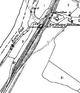 click to enlarge click to enlargeCSRY0034.jpg "Kershope Station / Lime Depot / M.P. Edinburgh [77] / Signal Post" |
|
|
|
||
 Lakes Guides menu.